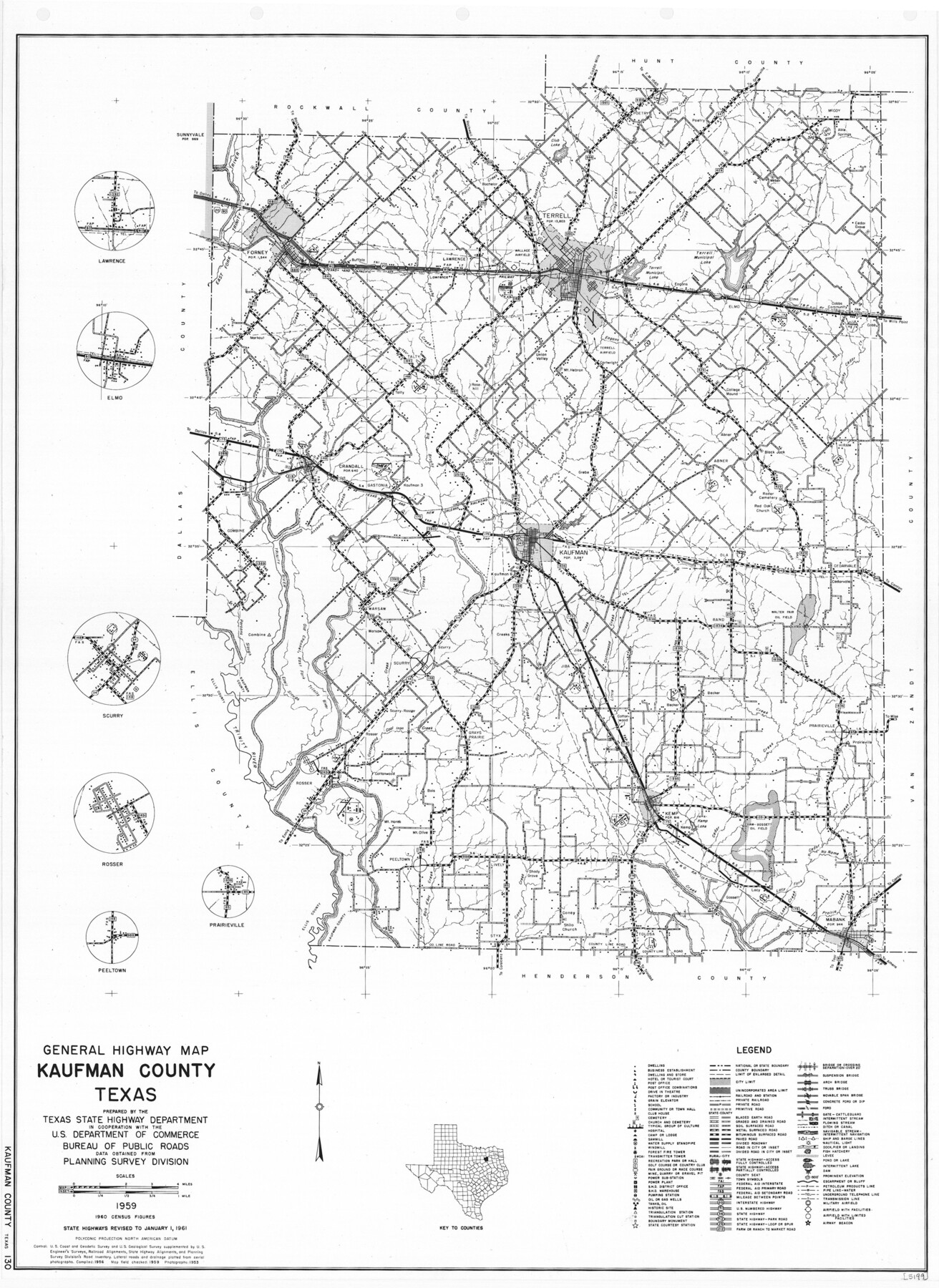
General Highway Map, Kaufman County, Texas
-
Map/Doc
79548
-
Collection
Texas State Library and Archives
-
Object Dates
1961 (Creation Date)
-
People and Organizations
Texas State Highway Department (Publisher)
-
Counties
Kaufman
-
Subjects
County
-
Height x Width
24.9 x 18.1 inches
63.3 x 46.0 cm
-
Comments
Prints available courtesy of the Texas State Library and Archives.
More info can be found here: TSLAC Map 05199
Part of: Texas State Library and Archives
General Highway Map, La Salle County, Texas

Print $20.00
General Highway Map, La Salle County, Texas
1961
Size 18.2 x 25.0 inches
Map/Doc 79564
Carte Reduite des Costes de la Louisiane et de la Floride

Print $20.00
Carte Reduite des Costes de la Louisiane et de la Floride
1764
Size 23.3 x 35.1 inches
Map/Doc 79295
General Highway Map, Haskell County, Texas

Print $20.00
General Highway Map, Haskell County, Texas
1940
Size 18.5 x 24.8 inches
Map/Doc 79122
General Highway Map, Collingsworth County, Texas

Print $20.00
General Highway Map, Collingsworth County, Texas
1961
Size 18.1 x 24.6 inches
Map/Doc 79415
General Highway Map, Callahan County, Texas

Print $20.00
General Highway Map, Callahan County, Texas
1940
Size 25.3 x 18.4 inches
Map/Doc 79037
Central America Including Texas, California, and the Northern States Mexico

Print $20.00
Central America Including Texas, California, and the Northern States Mexico
1842
Size 13.8 x 16.7 inches
Map/Doc 76273
General Highway Map, Collin County, Texas

Print $20.00
General Highway Map, Collin County, Texas
1961
Size 18.2 x 24.6 inches
Map/Doc 79413
General Highway Map, Bailey County, Texas

Print $20.00
General Highway Map, Bailey County, Texas
1961
Size 25.0 x 18.2 inches
Map/Doc 79359
General Highway Map, Matagorda County, Texas

Print $20.00
General Highway Map, Matagorda County, Texas
1939
Size 24.7 x 18.3 inches
Map/Doc 79187
General Highway Map, Fort Bend County, Texas

Print $20.00
General Highway Map, Fort Bend County, Texas
1939
Size 18.6 x 25.2 inches
Map/Doc 79093
General Highway Map, Llano County, Texas

Print $20.00
General Highway Map, Llano County, Texas
1961
Size 18.2 x 24.6 inches
Map/Doc 79576
General Highway Map, Hardeman County, Texas

Print $20.00
General Highway Map, Hardeman County, Texas
1961
Size 24.6 x 18.1 inches
Map/Doc 79498
You may also like
Gulf Intracoastal Waterway - Aransas Bay to Corpus Christi Bay - Modified Route Main Channel

Print $20.00
- Digital $50.00
Gulf Intracoastal Waterway - Aransas Bay to Corpus Christi Bay - Modified Route Main Channel
1960
Size 30.9 x 42.8 inches
Map/Doc 61900
Johnson County Working Sketch 18

Print $20.00
- Digital $50.00
Johnson County Working Sketch 18
1985
Size 18.3 x 26.0 inches
Map/Doc 66631
General Highway Map, Hidalgo County, Texas

Print $20.00
General Highway Map, Hidalgo County, Texas
1940
Size 18.4 x 25.0 inches
Map/Doc 79128
Map of Nacogdoches County

Print $20.00
- Digital $50.00
Map of Nacogdoches County
1881
Size 24.1 x 21.2 inches
Map/Doc 4603
Wilson County Sketch File 13

Print $4.00
- Digital $50.00
Wilson County Sketch File 13
1873
Size 10.2 x 8.0 inches
Map/Doc 40429
Index sheet to accompany map of survey for connecting the inland waters along margin of the Gulf of Mexico from Donaldsonville in Louisiana to the Rio Grande River in Texas

Print $20.00
- Digital $50.00
Index sheet to accompany map of survey for connecting the inland waters along margin of the Gulf of Mexico from Donaldsonville in Louisiana to the Rio Grande River in Texas
Size 18.2 x 27.5 inches
Map/Doc 72691
Jack County Sketch File 19

Print $4.00
- Digital $50.00
Jack County Sketch File 19
1878
Size 10.4 x 8.3 inches
Map/Doc 27559
Dallam County Sketch File 10

Print $20.00
- Digital $50.00
Dallam County Sketch File 10
1925
Size 7.2 x 8.6 inches
Map/Doc 20367
Stonewall County Sketch File AA1

Print $26.00
- Digital $50.00
Stonewall County Sketch File AA1
1916
Size 14.3 x 8.6 inches
Map/Doc 37288
"Iron Mountain Route" to all parts of Texas - I. & G. N., T. & P., Iron Mountain - "The Way to Texas"

Print $20.00
- Digital $50.00
"Iron Mountain Route" to all parts of Texas - I. & G. N., T. & P., Iron Mountain - "The Way to Texas"
1909
Size 21.8 x 24.0 inches
Map/Doc 95793
El Paso County State Real Property Sketch 4

Print $20.00
- Digital $50.00
El Paso County State Real Property Sketch 4
2012
Size 29.9 x 35.9 inches
Map/Doc 93701
Flight Mission No. DCL-7C, Frame 77, Kenedy County

Print $20.00
- Digital $50.00
Flight Mission No. DCL-7C, Frame 77, Kenedy County
1943
Size 15.3 x 15.2 inches
Map/Doc 86063