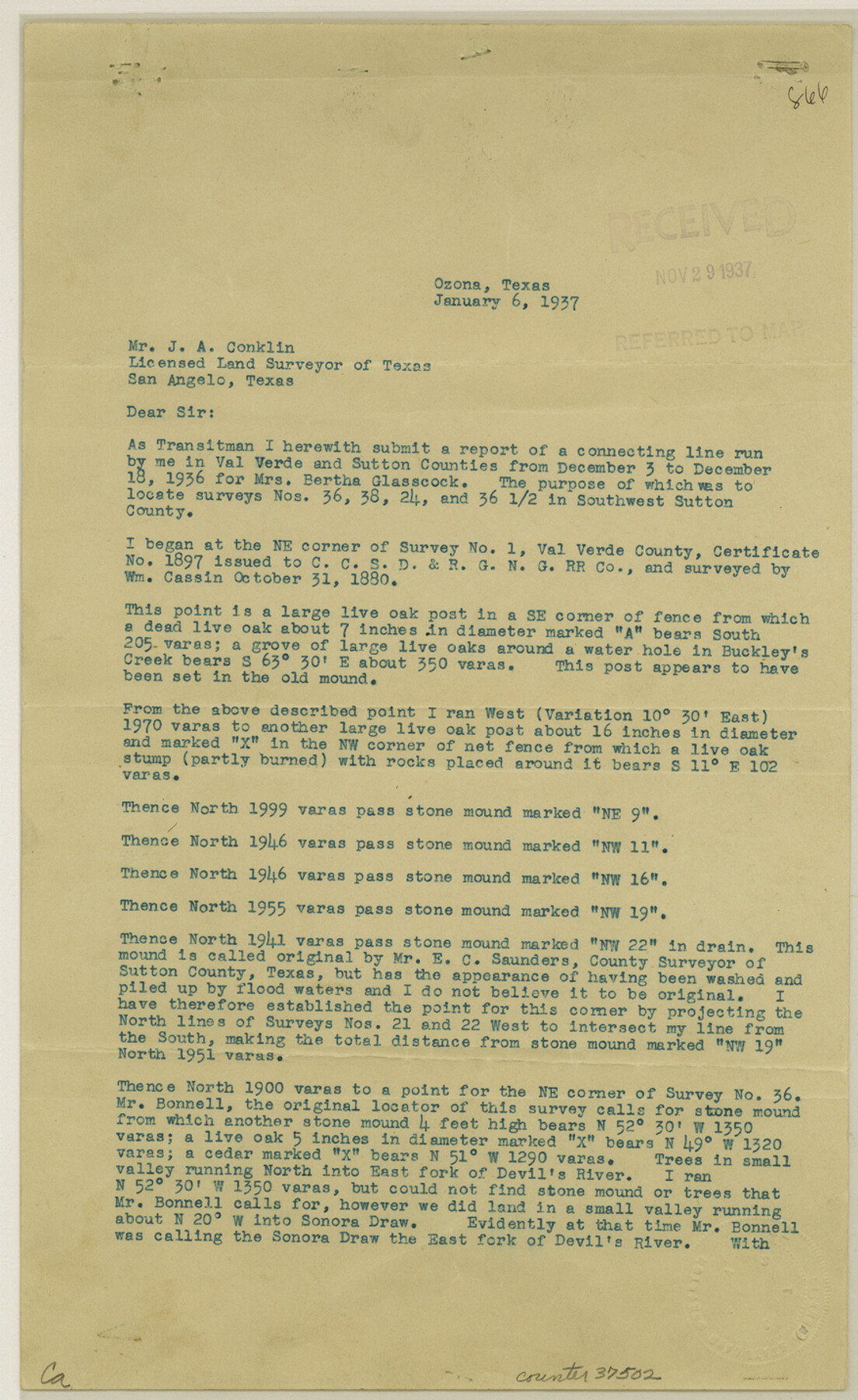
Sutton County Sketch File JAC (1)
[Survey report of area in southwest part of county]
-
Map/Doc
37502
-
Collection
General Map Collection
-
Object Dates
1/6/1937 (Creation Date)
11/26/1937 (File Date)
1/6/1937 (Correspondence Date)
12/18/1936 (Survey Date)
10/31/1880 (Survey Date)
-
People and Organizations
J.A. Conklin (Surveyor/Engineer)
William Cassin (Surveyor/Engineer)
Edgar C. Saunders (Surveyor/Engineer)
Bonnell (Surveyor/Engineer)
John McNichol (Surveyor/Engineer)
W.T. Hope (Surveyor/Engineer)
W.P. Conklin (Chainman/Field Personnel)
V.J. Glasscock (Surveyor/Engineer)
Charlie Taliaferro (Chainman/Field Personnel)
-
Counties
Sutton Val Verde
-
Subjects
Surveying Sketch File
-
Height x Width
14.3 x 8.8 inches
36.3 x 22.4 cm
-
Medium
paper, print
-
Features
Buckley's Creek
East Fork of Devil's River
Sonora Draw
Part of: General Map Collection
Rusk County Sketch File 16

Print $4.00
Rusk County Sketch File 16
1849
Size 13.0 x 8.4 inches
Map/Doc 35518
Pecos County Sketch File 46

Print $26.00
- Digital $50.00
Pecos County Sketch File 46
1921
Size 11.4 x 8.9 inches
Map/Doc 33746
Reagan County Sketch File 2

Print $2.00
- Digital $50.00
Reagan County Sketch File 2
Size 10.8 x 6.6 inches
Map/Doc 34979
Val Verde County Rolled Sketch 76

Print $20.00
- Digital $50.00
Val Verde County Rolled Sketch 76
1976
Size 38.6 x 26.6 inches
Map/Doc 8139
Kent County Working Sketch 11

Print $20.00
- Digital $50.00
Kent County Working Sketch 11
Size 24.3 x 37.4 inches
Map/Doc 70018
Van Zandt County Working Sketch 14

Print $20.00
- Digital $50.00
Van Zandt County Working Sketch 14
1982
Size 13.2 x 11.5 inches
Map/Doc 72264
Kent County Working Sketch 16

Print $20.00
- Digital $50.00
Kent County Working Sketch 16
1972
Size 32.4 x 31.5 inches
Map/Doc 70023
Dimmit County Rolled Sketch 3

Print $20.00
- Digital $50.00
Dimmit County Rolled Sketch 3
Size 31.9 x 36.2 inches
Map/Doc 76142
Uvalde County Working Sketch 38

Print $20.00
- Digital $50.00
Uvalde County Working Sketch 38
1970
Size 33.3 x 30.8 inches
Map/Doc 72108
Midland County Working Sketch 14

Print $40.00
- Digital $50.00
Midland County Working Sketch 14
1953
Size 65.0 x 31.0 inches
Map/Doc 70994
Reeves County Sketch File 1

Print $10.00
- Digital $50.00
Reeves County Sketch File 1
Size 9.0 x 15.8 inches
Map/Doc 35176
El Paso County Rolled Sketch VD

Print $40.00
- Digital $50.00
El Paso County Rolled Sketch VD
1915
Size 18.4 x 67.4 inches
Map/Doc 8862
You may also like
Brazoria County Working Sketch 2

Print $20.00
- Digital $50.00
Brazoria County Working Sketch 2
1907
Size 20.9 x 20.8 inches
Map/Doc 67487
Jefferson County Rolled Sketch 5

Print $20.00
- Digital $50.00
Jefferson County Rolled Sketch 5
1913
Size 47.0 x 40.7 inches
Map/Doc 9270
DeWitt County Working Sketch 11

Print $20.00
- Digital $50.00
DeWitt County Working Sketch 11
1980
Size 15.9 x 12.8 inches
Map/Doc 68601
Farm Owned by Dr. J. T. Krueger

Print $20.00
- Digital $50.00
Farm Owned by Dr. J. T. Krueger
Size 16.9 x 32.8 inches
Map/Doc 92344
McMullen County Working Sketch 43

Print $20.00
- Digital $50.00
McMullen County Working Sketch 43
1980
Size 35.2 x 28.1 inches
Map/Doc 70744
Kimble County Rolled Sketch 33

Print $20.00
- Digital $50.00
Kimble County Rolled Sketch 33
1973
Size 26.7 x 20.1 inches
Map/Doc 6523
Brewster County Rolled Sketch 73

Print $20.00
- Digital $50.00
Brewster County Rolled Sketch 73
1938
Size 19.7 x 23.3 inches
Map/Doc 5239
Flight Mission No. BQR-5K, Frame 72, Brazoria County

Print $20.00
- Digital $50.00
Flight Mission No. BQR-5K, Frame 72, Brazoria County
1952
Size 18.9 x 22.4 inches
Map/Doc 84017
Tom Green County Sketch File 83

Print $20.00
- Digital $50.00
Tom Green County Sketch File 83
1889
Size 20.5 x 22.2 inches
Map/Doc 12455
Cherokee County Sketch File 9

Print $8.00
- Digital $50.00
Cherokee County Sketch File 9
1853
Size 5.6 x 4.2 inches
Map/Doc 18132
Refugio County, Texas

Print $20.00
- Digital $50.00
Refugio County, Texas
1879
Size 19.9 x 29.0 inches
Map/Doc 600
Foard County Sketch File 36

Print $20.00
- Digital $50.00
Foard County Sketch File 36
Size 15.4 x 28.0 inches
Map/Doc 11498