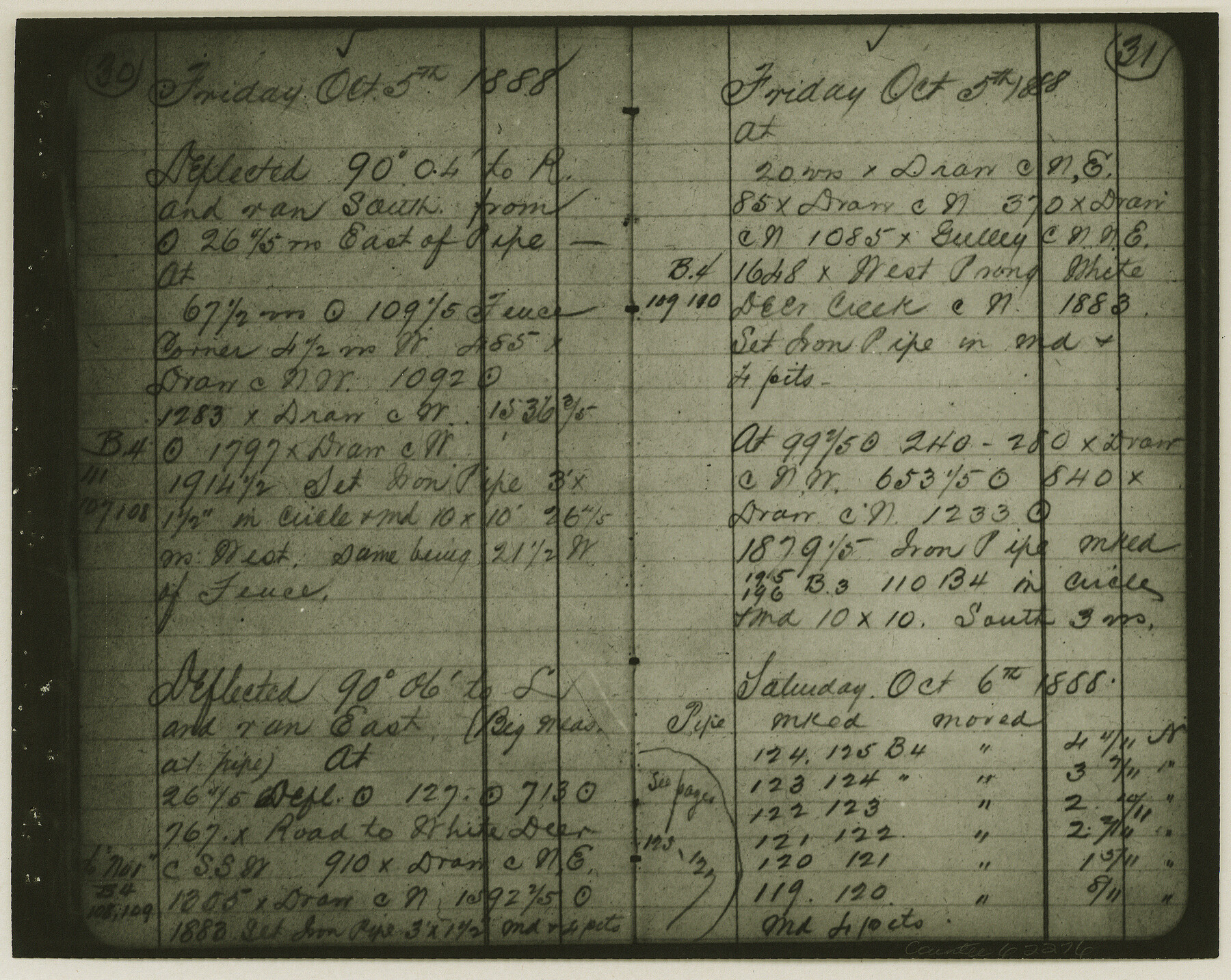
Copy of Surveyor's Field Book, Morris Browning - In Blocks 7, 5 & 4, I&GNRRCo., Hutchinson and Carson Counties, Texas
K-7-70
-
Map/Doc
62276
-
Collection
General Map Collection
-
Object Dates
1888/10/22 (Creation Date)
-
People and Organizations
Morris Browning (Surveyor/Engineer)
-
Counties
Hutchinson Carson
-
Height x Width
7.0 x 8.8 inches
17.8 x 22.4 cm
-
Comments
Copy of Surveyor's field book presented to the General Land Office by Morris Browning on February 3, 1941.
Surveyed from September 14, 1888 to October 22, 1888.
Part of: General Map Collection
Map of Dickens County

Print $20.00
- Digital $50.00
Map of Dickens County
1899
Size 41.1 x 37.7 inches
Map/Doc 4933
Ector County Sketch File 12

Print $12.00
- Digital $50.00
Ector County Sketch File 12
1956
Size 11.4 x 9.0 inches
Map/Doc 21645
Bandera County Sketch File 8

Print $6.00
- Digital $50.00
Bandera County Sketch File 8
1878
Size 13.0 x 11.8 inches
Map/Doc 14007
Greer County Sketch File 2

Print $20.00
- Digital $50.00
Greer County Sketch File 2
1883
Size 25.4 x 19.9 inches
Map/Doc 11582
Map of Hill County

Print $20.00
- Digital $50.00
Map of Hill County
1862
Size 22.1 x 24.7 inches
Map/Doc 3671
Map of the River Sabine from Logan's Ferry to 32nd degree of north latitude

Print $2.00
- Digital $50.00
Map of the River Sabine from Logan's Ferry to 32nd degree of north latitude
1841
Size 8.6 x 10.5 inches
Map/Doc 65388
Menard County Rolled Sketch 14

Print $20.00
- Digital $50.00
Menard County Rolled Sketch 14
Size 39.8 x 34.1 inches
Map/Doc 6760
Castro County

Print $20.00
- Digital $50.00
Castro County
1891
Size 25.4 x 23.1 inches
Map/Doc 66750
Brewster County Rolled Sketch 60

Print $40.00
- Digital $50.00
Brewster County Rolled Sketch 60
1942
Size 42.9 x 48.0 inches
Map/Doc 16960
Collin County Boundary File 3

Print $12.00
- Digital $50.00
Collin County Boundary File 3
Size 10.9 x 7.0 inches
Map/Doc 51685
Crockett County Sketch File 95

Print $24.00
- Digital $50.00
Crockett County Sketch File 95
Size 11.2 x 8.9 inches
Map/Doc 19952
Montague County Sketch File 2

Print $24.00
- Digital $50.00
Montague County Sketch File 2
1856
Size 12.0 x 8.5 inches
Map/Doc 31711
You may also like
Map of Williamson County

Print $20.00
- Digital $50.00
Map of Williamson County
1856
Size 21.8 x 27.6 inches
Map/Doc 4149
Pecos County Working Sketch 51

Print $20.00
- Digital $50.00
Pecos County Working Sketch 51
1948
Size 22.5 x 21.9 inches
Map/Doc 71523
Gaines County Boundary File 1

Print $90.00
- Digital $50.00
Gaines County Boundary File 1
Size 14.4 x 9.0 inches
Map/Doc 53626
Mason County Boundary File 5a

Print $40.00
- Digital $50.00
Mason County Boundary File 5a
Size 18.0 x 32.6 inches
Map/Doc 56872
Coryell County Working Sketch 14

Print $20.00
- Digital $50.00
Coryell County Working Sketch 14
1950
Size 19.4 x 17.5 inches
Map/Doc 68221
General Highway Map, Briscoe County, Texas

Print $20.00
General Highway Map, Briscoe County, Texas
1961
Size 18.3 x 24.8 inches
Map/Doc 79387
Hudspeth County Rolled Sketch 78

Print $20.00
- Digital $50.00
Hudspeth County Rolled Sketch 78
2010
Size 18.4 x 24.5 inches
Map/Doc 93290
Nueces County Working Sketch 12

Print $20.00
- Digital $50.00
Nueces County Working Sketch 12
2011
Size 22.0 x 42.3 inches
Map/Doc 90047
Wilbarger County Sketch File 28

Print $20.00
- Digital $50.00
Wilbarger County Sketch File 28
2016
Size 23.9 x 36.2 inches
Map/Doc 95324

Flight Mission No. CUG-1P, Frame 163, Kleberg County

Print $20.00
- Digital $50.00
Flight Mission No. CUG-1P, Frame 163, Kleberg County
1956
Size 18.6 x 22.2 inches
Map/Doc 86170
Township No. 5 South, Range No. 13 West, Indian Meridian, Oklahoma

Print $4.00
- Digital $50.00
Township No. 5 South, Range No. 13 West, Indian Meridian, Oklahoma
1928
Size 17.9 x 23.0 inches
Map/Doc 75142