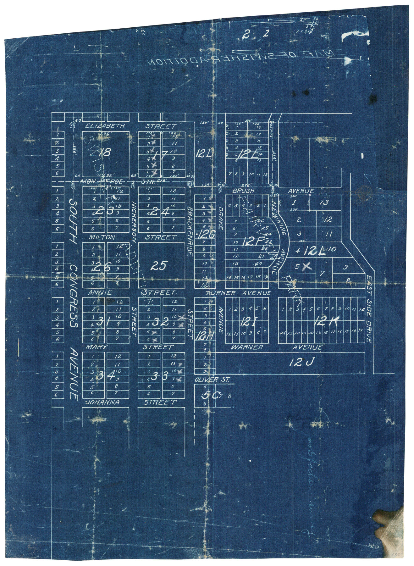
Map of Swisher Addition
-
Map/Doc
646
-
Collection
Maddox Collection
-
Object Dates
[1910 ca.] (Creation Date)
-
Counties
Travis
-
Subjects
City
-
Height x Width
18.0 x 13.3 inches
45.7 x 33.8 cm
-
Comments
Conservation funded in 2005 by Friends of the Texas General Land Office.
Part of: Maddox Collection
Midland County, Texas

Print $20.00
- Digital $50.00
Midland County, Texas
1888
Size 22.4 x 17.5 inches
Map/Doc 653
[Surveying Sketch of M. Farley, R. Word, S. S. Hervey, et al in Kleberg County, Texas]
![10783, [Surveying Sketch of M. Farley, R. Word, S. S. Hervey, et al in Kleberg County, Texas], Maddox Collection](https://historictexasmaps.com/wmedia_w700/maps/10783.tif.jpg)
Print $20.00
- Digital $50.00
[Surveying Sketch of M. Farley, R. Word, S. S. Hervey, et al in Kleberg County, Texas]
Size 23.2 x 40.6 inches
Map/Doc 10783
Austin and Surrounding Properties
.tif.jpg)
Print $20.00
- Digital $50.00
Austin and Surrounding Properties
1891
Size 42.9 x 32.1 inches
Map/Doc 421
Palo Pinto County, Texas

Print $20.00
- Digital $50.00
Palo Pinto County, Texas
1879
Size 17.8 x 19.0 inches
Map/Doc 529
"La Gloria Ranch", Duval Co. Texas

Print $20.00
- Digital $50.00
"La Gloria Ranch", Duval Co. Texas
Size 12.0 x 15.1 inches
Map/Doc 431
Block No. 45 of the H. & T. C. R.R. Co. and Block No. 4T of the T. & N. O. R.R. Co. in Hansford and Ochiltree Cos. as resurveyed by J.L. Long, State Surveyor

Print $20.00
- Digital $50.00
Block No. 45 of the H. & T. C. R.R. Co. and Block No. 4T of the T. & N. O. R.R. Co. in Hansford and Ochiltree Cos. as resurveyed by J.L. Long, State Surveyor
1888
Size 34.1 x 28.1 inches
Map/Doc 75820
Western portion of the Ward Ranch, Cottle, Foard & Hardeman Counties, Swearingen, Texas sold to Luther T. Clark

Print $20.00
- Digital $50.00
Western portion of the Ward Ranch, Cottle, Foard & Hardeman Counties, Swearingen, Texas sold to Luther T. Clark
1916
Size 30.4 x 30.7 inches
Map/Doc 4460
Map of Bastrop County, Texas

Print $20.00
- Digital $50.00
Map of Bastrop County, Texas
1879
Size 25.2 x 23.3 inches
Map/Doc 693
Gonzales County, Texas

Print $20.00
- Digital $50.00
Gonzales County, Texas
1880
Size 27.3 x 24.7 inches
Map/Doc 447
Map Showing Position of Surveys Represented Hereon

Print $40.00
- Digital $50.00
Map Showing Position of Surveys Represented Hereon
Size 39.6 x 57.9 inches
Map/Doc 75810
[Sketch of surveys in Hutchinson County]
![75817, [Sketch of surveys in Hutchinson County], Maddox Collection](https://historictexasmaps.com/wmedia_w700/maps/75817.tif.jpg)
Print $20.00
- Digital $50.00
[Sketch of surveys in Hutchinson County]
1912
Size 25.0 x 26.8 inches
Map/Doc 75817
Dimmit County, Texas

Print $20.00
- Digital $50.00
Dimmit County, Texas
1879
Size 22.5 x 29.0 inches
Map/Doc 710
You may also like
From Citizens of Montgomery County to Redefine the Boundary Between Harris and Montgomery Counties, May 8, 1838

Print $20.00
From Citizens of Montgomery County to Redefine the Boundary Between Harris and Montgomery Counties, May 8, 1838
2020
Size 15.4 x 21.7 inches
Map/Doc 96382

Scurry County Sketch Mineral Application No. 42315

Print $20.00
- Digital $50.00
Scurry County Sketch Mineral Application No. 42315
1950
Size 24.2 x 16.4 inches
Map/Doc 92926
Lipscomb County Boundary File 10

Print $18.00
- Digital $50.00
Lipscomb County Boundary File 10
Size 11.2 x 8.6 inches
Map/Doc 56338
Origin of Imports and Destination of Exports at Galveston, Tex., during 1921

Print $20.00
- Digital $50.00
Origin of Imports and Destination of Exports at Galveston, Tex., during 1921
1921
Size 13.1 x 24.6 inches
Map/Doc 97169
Yoakum County Sketch File 10a

Print $44.00
- Digital $50.00
Yoakum County Sketch File 10a
1928
Size 48.5 x 33.7 inches
Map/Doc 10437
Nueces County NRC Article 33.136 Location Key Sheet

Print $20.00
- Digital $50.00
Nueces County NRC Article 33.136 Location Key Sheet
1975
Size 27.0 x 23.0 inches
Map/Doc 88586

Reagan County Working Sketch 7

Print $20.00
- Digital $50.00
Reagan County Working Sketch 7
1939
Size 29.6 x 30.5 inches
Map/Doc 71847
El Paso County Sketch File 22

Print $22.00
- Digital $50.00
El Paso County Sketch File 22
1888
Size 14.2 x 9.0 inches
Map/Doc 22031
Shackelford County

Print $20.00
- Digital $50.00
Shackelford County
1920
Size 44.6 x 37.1 inches
Map/Doc 16813
Brewster County Rolled Sketch OS

Print $20.00
- Digital $50.00
Brewster County Rolled Sketch OS
Size 17.6 x 21.7 inches
Map/Doc 5323