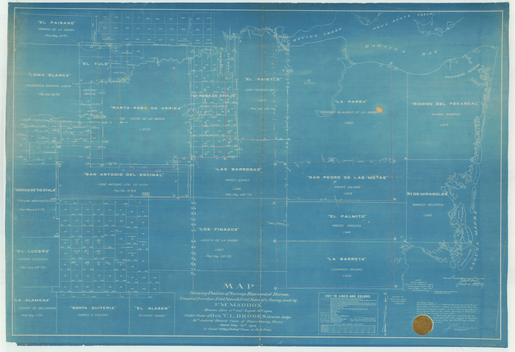
Map Showing Position of Surveys Represented Hereon
-
Map/Doc
75810
-
Collection
Maddox Collection
-
Object Dates
1904/11/3 (File Date)
-
Counties
Kenedy Brooks Kleberg
-
Height x Width
39.6 x 57.9 inches
100.6 x 147.1 cm
Part of: Maddox Collection
Survey for H.A. Wroe

Print $20.00
- Digital $50.00
Survey for H.A. Wroe
Size 19.6 x 10.4 inches
Map/Doc 601
Sketch of Dickens Co.

Print $20.00
- Digital $50.00
Sketch of Dickens Co.
1884
Size 17.6 x 14.5 inches
Map/Doc 75766
Winkler County, Texas

Print $20.00
- Digital $50.00
Winkler County, Texas
1889
Size 24.6 x 19.0 inches
Map/Doc 658
Sketch of Kent Co.

Print $20.00
- Digital $50.00
Sketch of Kent Co.
1884
Size 15.1 x 16.5 inches
Map/Doc 439
Saline Ranch in Mason, Kimble and Menard Counties

Print $20.00
- Digital $50.00
Saline Ranch in Mason, Kimble and Menard Counties
1916
Size 28.3 x 27.2 inches
Map/Doc 75806
[McK. & Williams No. 601 and surrounding surveys, Travis County]
![10782, [McK. & Williams No. 601 and surrounding surveys, Travis County], Maddox Collection](https://historictexasmaps.com/wmedia_w700/maps/10782.tif.jpg)
Print $20.00
- Digital $50.00
[McK. & Williams No. 601 and surrounding surveys, Travis County]
Size 18.3 x 12.3 inches
Map/Doc 10782
[Northern Portion of] Cottle County
![4436, [Northern Portion of] Cottle County, Maddox Collection](https://historictexasmaps.com/wmedia_w700/maps/4436.tif.jpg)
Print $20.00
- Digital $50.00
[Northern Portion of] Cottle County
1908
Size 28.4 x 29.5 inches
Map/Doc 4436

Working Sketch in Dimmit Co.

Print $20.00
- Digital $50.00
Working Sketch in Dimmit Co.
1883
Size 14.9 x 14.6 inches
Map/Doc 436
San Augustine County, Texas

Print $20.00
- Digital $50.00
San Augustine County, Texas
1879
Size 22.7 x 17.5 inches
Map/Doc 752

Map of Comal County, Texas

Print $20.00
- Digital $50.00
Map of Comal County, Texas
1879
Size 23.4 x 28.6 inches
Map/Doc 701
You may also like
Hansford County, Texas

Print $20.00
- Digital $50.00
Hansford County, Texas
1880
Size 19.9 x 18.9 inches
Map/Doc 528
Liberty County Sketch File 36a

Print $4.00
- Digital $50.00
Liberty County Sketch File 36a
Size 8.6 x 5.6 inches
Map/Doc 29974
West Houston: Hwy. 6 from Spencer Rd. in the North to South of Sugar Land. From Wilcrest Dr. in the East to and including Katy.

West Houston: Hwy. 6 from Spencer Rd. in the North to South of Sugar Land. From Wilcrest Dr. in the East to and including Katy.
Size 35.4 x 22.8 inches
Map/Doc 94335
Texas Gulf Coast Map from the Sabine River to the Rio Grande as subdivided for mineral development

Print $40.00
- Digital $50.00
Texas Gulf Coast Map from the Sabine River to the Rio Grande as subdivided for mineral development
1948
Size 48.9 x 38.0 inches
Map/Doc 2910
Wood County Working Sketch 20

Print $40.00
- Digital $50.00
Wood County Working Sketch 20
1985
Size 42.6 x 48.6 inches
Map/Doc 62020
Flight Mission No. DQN-2K, Frame 94, Calhoun County

Print $20.00
- Digital $50.00
Flight Mission No. DQN-2K, Frame 94, Calhoun County
1953
Size 16.6 x 16.2 inches
Map/Doc 84284
Montgomery County Working Sketch 21

Print $20.00
- Digital $50.00
Montgomery County Working Sketch 21
1936
Size 16.4 x 37.0 inches
Map/Doc 71128
Harris County Rolled Sketch 92

Print $20.00
- Digital $50.00
Harris County Rolled Sketch 92
1980
Size 40.1 x 28.1 inches
Map/Doc 6132
Deaf Smith County Sketch File E

Print $20.00
- Digital $50.00
Deaf Smith County Sketch File E
Size 22.3 x 12.9 inches
Map/Doc 11308
Map of the World on Mercator's Projection, flags of all nations and cities of the United States

Print $40.00
- Digital $50.00
Map of the World on Mercator's Projection, flags of all nations and cities of the United States
1874
Size 40.4 x 55.6 inches
Map/Doc 93914
Nacogdoches County Boundary File 1b

Print $20.00
- Digital $50.00
Nacogdoches County Boundary File 1b
Size 21.2 x 4.9 inches
Map/Doc 57580
San Patricio County Rolled Sketch 47

Print $20.00
- Digital $50.00
San Patricio County Rolled Sketch 47
1939
Size 27.6 x 29.6 inches
Map/Doc 7731