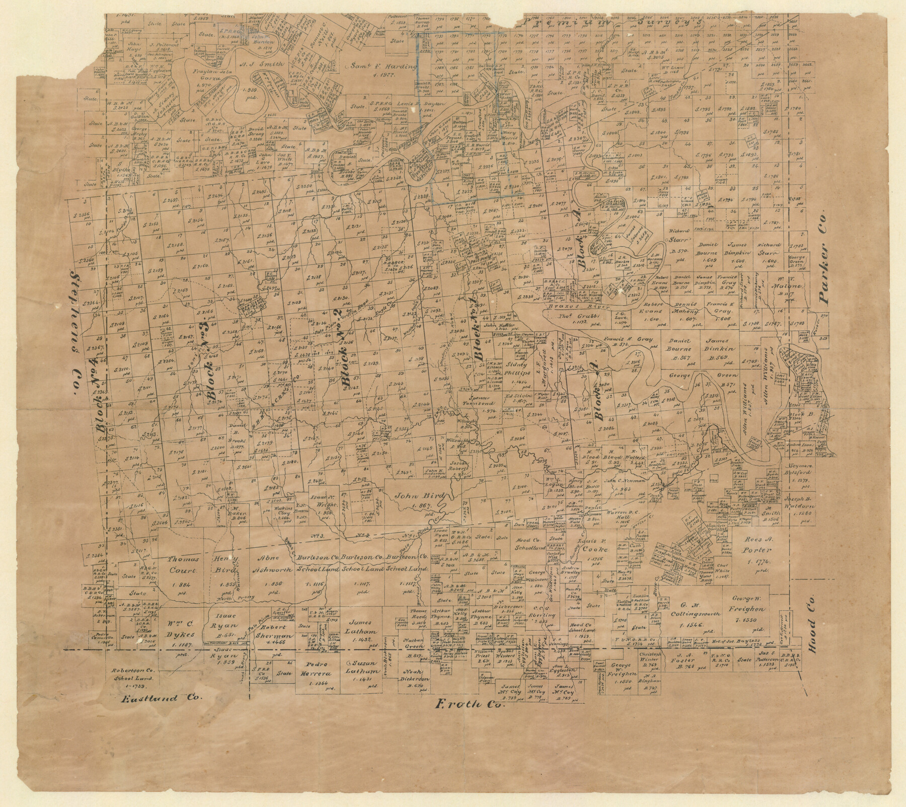
Palo Pinto County, Texas
-
Map/Doc
529
-
Collection
Maddox Collection
-
Object Dates
1879 (Creation Date)
-
Counties
Palo Pinto
-
Subjects
County
-
Height x Width
17.8 x 19.0 inches
45.2 x 48.3 cm
-
Medium
paper, etching/engraving/lithograph
-
Comments
Conservation funded in 2012 by Friends of the Texas General Land Office.
-
Features
Stephensville [sic] Road
South Prong of Palo Pinto Creek
North Prong of Palo Pinto Creek
Walnut Creek
Boles Creek
Bartons Creek
Buck Creek
Sunday Creek
Worser Creek
Ioni Creek
Lake Creek
Cedar Bluff Creek
Rock Creek
Brazos River
West Fork of Eagle Creek
Eagle Creek
Griffin Road
Palo Pinto Road
Palo Pinto and Griffin Road
Caddo Creek
Turkey Creek
Keechi Creek
Part of: Maddox Collection
Plat of Surveys in Hidalgo Co.

Print $20.00
- Digital $50.00
Plat of Surveys in Hidalgo Co.
Size 18.3 x 9.2 inches
Map/Doc 75548
Map of Tyler County, Texas

Print $20.00
- Digital $50.00
Map of Tyler County, Texas
1879
Size 28.6 x 22.8 inches
Map/Doc 720
Map of Orange County, Texas

Print $20.00
- Digital $50.00
Map of Orange County, Texas
1880
Size 15.6 x 19.1 inches
Map/Doc 746
Map of Franklin County, Texas

Print $20.00
- Digital $50.00
Map of Franklin County, Texas
1879
Size 23.4 x 11.3 inches
Map/Doc 728
Dimmit County, Texas

Print $20.00
- Digital $50.00
Dimmit County, Texas
1879
Size 22.5 x 29.0 inches
Map/Doc 710
[Sketch of Surveys in Brooks County, Texas]
![10775, [Sketch of Surveys in Brooks County, Texas], Maddox Collection](https://historictexasmaps.com/wmedia_w700/maps/10775.tif.jpg)
Print $20.00
- Digital $50.00
[Sketch of Surveys in Brooks County, Texas]
Size 12.1 x 12.4 inches
Map/Doc 10775
Sketch of Crosby Co.

Print $20.00
- Digital $50.00
Sketch of Crosby Co.
1884
Size 14.8 x 12.5 inches
Map/Doc 506
[Highway Map of the State of Texas]
![5039, [Highway Map of the State of Texas], Maddox Collection](https://historictexasmaps.com/wmedia_w700/maps/5039-1.tif.jpg)
Print $20.00
- Digital $50.00
[Highway Map of the State of Texas]
1923
Size 44.7 x 46.7 inches
Map/Doc 5039
Map of survey 189, T. C. R.R. Co. in Travis County, Texas

Print $20.00
- Digital $50.00
Map of survey 189, T. C. R.R. Co. in Travis County, Texas
1915
Size 18.6 x 15.2 inches
Map/Doc 78479
Jasper County

Print $20.00
- Digital $50.00
Jasper County
1882
Size 17.6 x 14.0 inches
Map/Doc 75779

[Sketch of Surveys Near Port Aransas and Aransas Pass, Aransas County, Texas]
![676, [Sketch of Surveys Near Port Aransas and Aransas Pass, Aransas County, Texas], Maddox Collection](https://historictexasmaps.com/wmedia_w700/maps/676.tif.jpg)
Print $20.00
- Digital $50.00
[Sketch of Surveys Near Port Aransas and Aransas Pass, Aransas County, Texas]
Size 22.8 x 18.5 inches
Map/Doc 676
You may also like
Flight Mission No. DQN-2K, Frame 140, Calhoun County

Print $20.00
- Digital $50.00
Flight Mission No. DQN-2K, Frame 140, Calhoun County
1953
Size 17.2 x 15.9 inches
Map/Doc 84309
Flight Mission No. DQN-4K, Frame 8, Calhoun County

Print $20.00
- Digital $50.00
Flight Mission No. DQN-4K, Frame 8, Calhoun County
1953
Size 18.8 x 22.5 inches
Map/Doc 84373
Val Verde County Rolled Sketch 1

Print $40.00
- Digital $50.00
Val Verde County Rolled Sketch 1
1885
Size 69.8 x 39.1 inches
Map/Doc 10068

[Letter from T. F. Pinckney to W. D. Twichell accompanying sketch showing Blocks 14, 341, and G5]
![93110, [Letter from T. F. Pinckney to W. D. Twichell accompanying sketch showing Blocks 14, 341, and G5], Twichell Survey Records](https://historictexasmaps.com/wmedia_w700/maps/93110-1.tif.jpg)
Print $2.00
- Digital $50.00
[Letter from T. F. Pinckney to W. D. Twichell accompanying sketch showing Blocks 14, 341, and G5]
1911
Size 8.0 x 9.5 inches
Map/Doc 93110
Fractional Township No. 6 South Range No. 5 West of the Indian Meridian, Indian Territory

Print $20.00
- Digital $50.00
Fractional Township No. 6 South Range No. 5 West of the Indian Meridian, Indian Territory
1898
Size 19.3 x 24.3 inches
Map/Doc 75190
Cooke County Sketch File 10

Print $4.00
- Digital $50.00
Cooke County Sketch File 10
1855
Size 13.0 x 8.4 inches
Map/Doc 19242
Map of Upton County

Print $20.00
- Digital $50.00
Map of Upton County
1899
Size 47.3 x 41.1 inches
Map/Doc 16909
Parker County Sketch File 15A

Print $20.00
- Digital $50.00
Parker County Sketch File 15A
1875
Size 28.5 x 13.6 inches
Map/Doc 12144
Presidio County Working Sketch 37

Print $20.00
- Digital $50.00
Presidio County Working Sketch 37
1948
Size 26.9 x 43.3 inches
Map/Doc 71714
Midland County Sketch File 3

Print $20.00
- Digital $50.00
Midland County Sketch File 3
1886
Size 18.3 x 25.2 inches
Map/Doc 12081
The Republic County of Washington. January 15, 1842

Print $20.00
The Republic County of Washington. January 15, 1842
2020
Size 11.8 x 21.7 inches
Map/Doc 96306