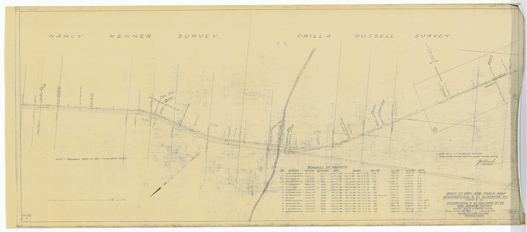
Right of Way and Track Map International & Gt Northern Ry. operated by the International & Gt. Northern Ry. Co., San Antonio Division
Station 11667+73 to Station 11877+80
Z-2-181
-
Map/Doc
64587
-
Collection
General Map Collection
-
Object Dates
1921/1/20 (Revision Date)
1917/6/19 (Creation Date)
-
People and Organizations
J. C. Resch (Surveyor/Engineer)
-
Counties
Comal
-
Subjects
Railroads
-
Height x Width
25.6 x 58.1 inches
65.0 x 147.6 cm
-
Medium
blueprint/diazo
-
Scale
1" = 400 feet
-
Comments
See counter nos. 64586 and 64588 through 64589 and 64787 through 64789 for other sheets of the map.
-
Features
I&GN
MK&T
Goodwin
Geronimo Creek
Part of: General Map Collection
Menard County Working Sketch 27

Print $20.00
- Digital $50.00
Menard County Working Sketch 27
1962
Size 38.2 x 43.8 inches
Map/Doc 70974
Travis County State Real Property Sketch 4

Print $20.00
- Digital $50.00
Travis County State Real Property Sketch 4
1987
Size 25.7 x 30.7 inches
Map/Doc 61695
FT. W. & R. G. Ry. Right of Way Map, Winchell to Brady, McCulloch County, Texas

Print $20.00
- Digital $50.00
FT. W. & R. G. Ry. Right of Way Map, Winchell to Brady, McCulloch County, Texas
1918
Size 36.9 x 32.0 inches
Map/Doc 61416
Trinity County Working Sketch 16

Print $20.00
- Digital $50.00
Trinity County Working Sketch 16
Size 31.7 x 41.2 inches
Map/Doc 69465
Wise County Sketch File 51

Print $2.00
- Digital $50.00
Wise County Sketch File 51
Size 8.5 x 3.9 inches
Map/Doc 40618
Hardin County Sketch File 19

Print $6.00
- Digital $50.00
Hardin County Sketch File 19
Size 13.0 x 10.9 inches
Map/Doc 25135
Milam County Working Sketch 9

Print $20.00
- Digital $50.00
Milam County Working Sketch 9
1976
Size 27.2 x 22.7 inches
Map/Doc 71024
Wichita Falls, Wichita County, Texas

Print $20.00
- Digital $50.00
Wichita Falls, Wichita County, Texas
Size 32.0 x 22.6 inches
Map/Doc 96791
[Surveys in the Bexar District along the Cibolo Creek]
![98, [Surveys in the Bexar District along the Cibolo Creek], General Map Collection](https://historictexasmaps.com/wmedia_w700/maps/98.tif.jpg)
Print $2.00
- Digital $50.00
[Surveys in the Bexar District along the Cibolo Creek]
1847
Size 13.0 x 7.4 inches
Map/Doc 98
Orange County Rolled Sketch 24

Print $245.00
- Digital $50.00
Orange County Rolled Sketch 24
1950
Size 10.5 x 15.4 inches
Map/Doc 47946
Zapata County Working Sketch 1

Print $20.00
- Digital $50.00
Zapata County Working Sketch 1
Size 26.2 x 25.7 inches
Map/Doc 62052
Coke County Working Sketch 27

Print $20.00
- Digital $50.00
Coke County Working Sketch 27
1962
Size 17.4 x 27.7 inches
Map/Doc 68064
You may also like
Guadalupe County

Print $20.00
- Digital $50.00
Guadalupe County
1977
Size 35.9 x 46.4 inches
Map/Doc 73165
Right of Way and Track Map, the Missouri, Kansas and Texas Ry. of Texas - Henrietta Division

Print $20.00
- Digital $50.00
Right of Way and Track Map, the Missouri, Kansas and Texas Ry. of Texas - Henrietta Division
1918
Size 11.8 x 26.8 inches
Map/Doc 64755
Flight Mission No. BRA-7M, Frame 141, Jefferson County

Print $20.00
- Digital $50.00
Flight Mission No. BRA-7M, Frame 141, Jefferson County
1953
Size 18.6 x 22.4 inches
Map/Doc 85535
Flight Mission No. DQO-8K, Frame 84, Galveston County

Print $20.00
- Digital $50.00
Flight Mission No. DQO-8K, Frame 84, Galveston County
1952
Size 18.6 x 22.5 inches
Map/Doc 85186
Texas Railroad Map

Print $20.00
- Digital $50.00
Texas Railroad Map
1981
Size 34.8 x 35.6 inches
Map/Doc 2101
Flight Mission No. BRE-2P, Frame 34, Nueces County

Print $20.00
- Digital $50.00
Flight Mission No. BRE-2P, Frame 34, Nueces County
1956
Size 18.7 x 22.6 inches
Map/Doc 86736
Brazoria County Working Sketch 47

Print $40.00
- Digital $50.00
Brazoria County Working Sketch 47
1988
Size 35.3 x 59.9 inches
Map/Doc 67532
Angelina County Working Sketch 30

Print $20.00
- Digital $50.00
Angelina County Working Sketch 30
1955
Size 26.2 x 27.7 inches
Map/Doc 67112
Webb County Sketch File 55

Print $20.00
- Digital $50.00
Webb County Sketch File 55
1940
Size 20.6 x 12.6 inches
Map/Doc 12650
Pressler's Map of the State of Texas

Print $40.00
Pressler's Map of the State of Texas
1858
Size 48.0 x 52.5 inches
Map/Doc 76232
Map of Hamilton County

Print $20.00
- Digital $50.00
Map of Hamilton County
1872
Size 14.9 x 21.9 inches
Map/Doc 4556
Karnes County Boundary File 2

Print $12.00
- Digital $50.00
Karnes County Boundary File 2
Size 14.1 x 8.7 inches
Map/Doc 55686