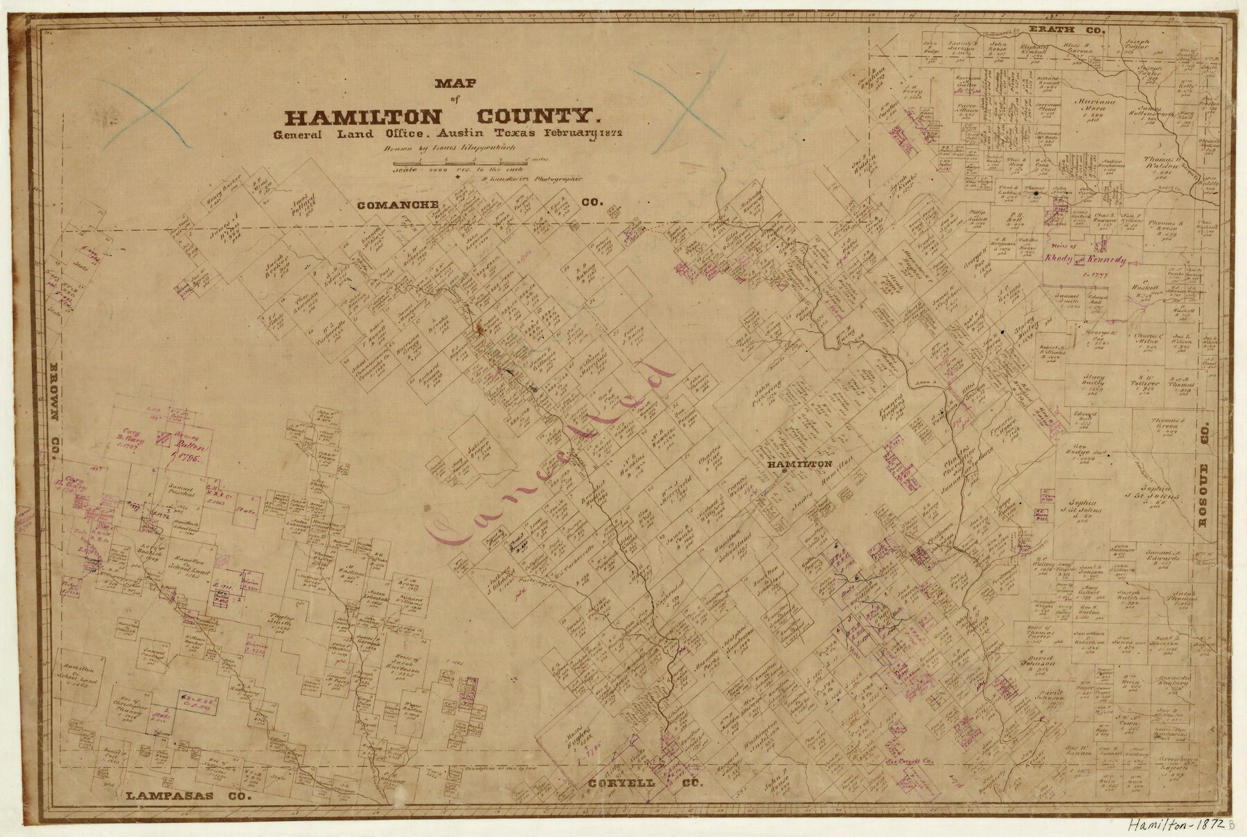
Map of Hamilton County
-
Map/Doc
4556
-
Collection
General Map Collection
-
Object Dates
2/1872 (Creation Date)
-
People and Organizations
L. Klappenbach (Draftsman)
Herman Lungkwitz (Draftsman)
-
Counties
Hamilton
-
Subjects
County
-
Height x Width
14.9 x 21.9 inches
37.9 x 55.6 cm
-
Features
Partridge Creek
Cow House Creek
South Bennett's Creek
North Fork of Lampasas River
Meridian Creek
Sycamore Creek
Alexander Creek
Comanche Creek
Hamilton
Gillmore's Creek
Merell Creek
Bennett's Creek
Warring's Creek
Bear Creek
Leon River
Honey Creek
Bosque Creek
Part of: General Map Collection
[Surveys in Liberty County]
![69750, [Surveys in Liberty County], General Map Collection](https://historictexasmaps.com/wmedia_w700/maps/69750.tif.jpg)
Print $2.00
- Digital $50.00
[Surveys in Liberty County]
Size 5.8 x 9.3 inches
Map/Doc 69750
Pecos County Rolled Sketch 132

Print $20.00
- Digital $50.00
Pecos County Rolled Sketch 132
Size 32.8 x 38.9 inches
Map/Doc 9728
Township No. 5 South Range No. 9 West of the Indian Meridian

Print $20.00
- Digital $50.00
Township No. 5 South Range No. 9 West of the Indian Meridian
1874
Size 19.2 x 24.4 inches
Map/Doc 75167
Flight Mission No. DQN-1K, Frame 144, Calhoun County

Print $20.00
- Digital $50.00
Flight Mission No. DQN-1K, Frame 144, Calhoun County
1953
Size 18.5 x 22.2 inches
Map/Doc 84207
Map of Brown County

Print $40.00
- Digital $50.00
Map of Brown County
1886
Size 48.9 x 41.6 inches
Map/Doc 3342
Collin County Boundary File 18b

Print $24.00
- Digital $50.00
Collin County Boundary File 18b
Size 12.7 x 8.1 inches
Map/Doc 51721

Kerr County Rolled Sketch 14

Print $20.00
- Digital $50.00
Kerr County Rolled Sketch 14
1951
Size 38.3 x 30.6 inches
Map/Doc 9345
Right of Way and Track Map, International & Gt. Northern Ry. operated by the International & Gt. Northern Ry. Co. Gulf Division, Mineola Branch

Print $40.00
- Digital $50.00
Right of Way and Track Map, International & Gt. Northern Ry. operated by the International & Gt. Northern Ry. Co. Gulf Division, Mineola Branch
1917
Size 26.3 x 125.4 inches
Map/Doc 64700
[Galveston, Harrisburg & San Antonio Railway]
![64403, [Galveston, Harrisburg & San Antonio Railway], General Map Collection](https://historictexasmaps.com/wmedia_w700/maps/64403.tif.jpg)
Print $20.00
- Digital $50.00
[Galveston, Harrisburg & San Antonio Railway]
1892
Size 13.7 x 33.7 inches
Map/Doc 64403
Milam County Rolled Sketch 5A

Print $20.00
- Digital $50.00
Milam County Rolled Sketch 5A
1997
Size 28.0 x 39.8 inches
Map/Doc 6778
Dawson County

Print $20.00
- Digital $50.00
Dawson County
1959
Size 43.5 x 35.1 inches
Map/Doc 77259
You may also like
Coast Chart No. 210 - Aransas Pass and Corpus Christi Bay with the coast to latitude 27° 12', Texas

Print $20.00
- Digital $50.00
Coast Chart No. 210 - Aransas Pass and Corpus Christi Bay with the coast to latitude 27° 12', Texas
1907
Size 44.2 x 36.5 inches
Map/Doc 73449
Liberty County Sketch File 7

Print $4.00
- Digital $50.00
Liberty County Sketch File 7
Size 13.4 x 6.2 inches
Map/Doc 29897
Hays County Boundary File 1

Print $14.00
- Digital $50.00
Hays County Boundary File 1
Size 9.5 x 5.2 inches
Map/Doc 54586
Fractional Township No. 9 South Range No. 2 East of the Indian Meridian, Indian Territory

Print $20.00
- Digital $50.00
Fractional Township No. 9 South Range No. 2 East of the Indian Meridian, Indian Territory
1898
Size 19.1 x 24.2 inches
Map/Doc 75203
Flight Mission No. BQR-20K, Frame 10, Brazoria County

Print $20.00
- Digital $50.00
Flight Mission No. BQR-20K, Frame 10, Brazoria County
1952
Size 18.6 x 22.3 inches
Map/Doc 84112
Dimmit County Boundary File 4

Print $14.00
- Digital $50.00
Dimmit County Boundary File 4
Size 14.1 x 8.8 inches
Map/Doc 52570
[Map of Line Dividing Fannin and Nacogdoches Districts]
![1707, [Map of Line Dividing Fannin and Nacogdoches Districts], General Map Collection](https://historictexasmaps.com/wmedia_w700/maps/1707-1.tif.jpg)
Print $20.00
- Digital $50.00
[Map of Line Dividing Fannin and Nacogdoches Districts]
1850
Size 34.2 x 39.0 inches
Map/Doc 1707
Map of Bexar County, Texas

Print $20.00
- Digital $50.00
Map of Bexar County, Texas
1879
Size 25.1 x 29.7 inches
Map/Doc 530


Harris County Working Sketch 122

Print $20.00
- Digital $50.00
Harris County Working Sketch 122
1986
Size 30.0 x 40.1 inches
Map/Doc 66014
[Mrs. May Vinson Survey]
![91919, [Mrs. May Vinson Survey], Twichell Survey Records](https://historictexasmaps.com/wmedia_w700/maps/91919-1.tif.jpg)
Print $20.00
- Digital $50.00
[Mrs. May Vinson Survey]
Size 32.8 x 14.9 inches
Map/Doc 91919