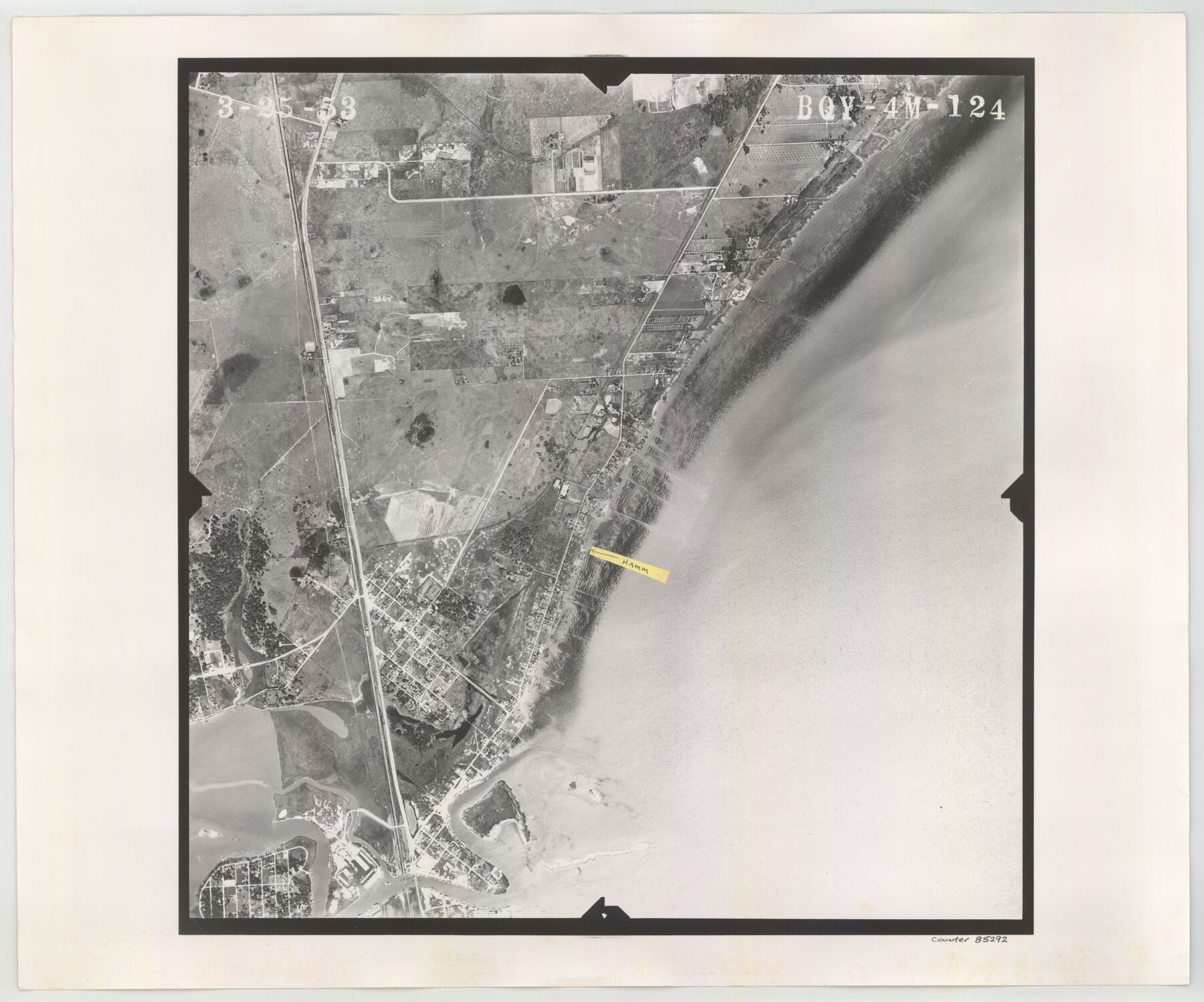
Flight Mission No. BQY-4M, Frame 124, Harris County
BQY-4M-124
-
Map/Doc
85292
-
Collection
General Map Collection
-
Object Dates
1953/3/25 (Creation Date)
-
People and Organizations
U. S. Department of Agriculture (Publisher)
-
Counties
Harris
-
Subjects
Aerial Photograph
-
Height x Width
18.7 x 22.4 inches
47.5 x 56.9 cm
-
Comments
Flown by Jack Ammann Photogrammetric Engineers of San Antonio, Texas.
Part of: General Map Collection
Flight Mission No. BRA-16M, Frame 146, Jefferson County

Print $20.00
- Digital $50.00
Flight Mission No. BRA-16M, Frame 146, Jefferson County
1953
Size 18.4 x 22.3 inches
Map/Doc 85752
[Right of Way & Track Map, The Texas & Pacific Ry. Co. Main Line]
![64688, [Right of Way & Track Map, The Texas & Pacific Ry. Co. Main Line], General Map Collection](https://historictexasmaps.com/wmedia_w700/maps/64688.tif.jpg)
Print $20.00
- Digital $50.00
[Right of Way & Track Map, The Texas & Pacific Ry. Co. Main Line]
Size 11.0 x 19.0 inches
Map/Doc 64688
Flight Mission No. DAG-24K, Frame 53, Matagorda County

Print $20.00
- Digital $50.00
Flight Mission No. DAG-24K, Frame 53, Matagorda County
1953
Size 18.5 x 22.3 inches
Map/Doc 86540
Newton County Sketch File 26

Print $4.00
- Digital $50.00
Newton County Sketch File 26
1893
Size 11.2 x 8.8 inches
Map/Doc 32409
Andrews County Working Sketch 13

Print $20.00
- Digital $50.00
Andrews County Working Sketch 13
1956
Size 37.3 x 30.6 inches
Map/Doc 67059

Gregg County Boundary File 6

Print $6.00
- Digital $50.00
Gregg County Boundary File 6
Size 8.5 x 5.8 inches
Map/Doc 54001
Edwards County Sketch File 15

Print $10.00
- Digital $50.00
Edwards County Sketch File 15
1893
Size 12.9 x 8.5 inches
Map/Doc 21715
McMullen County Sketch File 26

Print $20.00
- Digital $50.00
McMullen County Sketch File 26
1884
Size 14.7 x 19.8 inches
Map/Doc 12060
Terrell County Rolled Sketch 27

Print $20.00
- Digital $50.00
Terrell County Rolled Sketch 27
Size 24.8 x 20.7 inches
Map/Doc 7934
Morris County Rolled Sketch 2A

Print $20.00
- Digital $50.00
Morris County Rolled Sketch 2A
Size 24.0 x 18.8 inches
Map/Doc 10273
Webb County Rolled Sketch 40

Print $20.00
- Digital $50.00
Webb County Rolled Sketch 40
1941
Size 20.6 x 18.4 inches
Map/Doc 8195
You may also like
Mitchell County Sketch File 9

Print $8.00
- Digital $50.00
Mitchell County Sketch File 9
1909
Size 11.4 x 8.6 inches
Map/Doc 31694
Reagan County Sketch File 19

Print $26.00
- Digital $50.00
Reagan County Sketch File 19
1937
Size 14.0 x 28.7 inches
Map/Doc 12220
A New Map of Texas, Oregon, and California with the regions adjoining compiled from the most recent authorities

Print $20.00
- Digital $50.00
A New Map of Texas, Oregon, and California with the regions adjoining compiled from the most recent authorities
1846
Size 23.0 x 21.2 inches
Map/Doc 95748
[Sketches on Lagoona (sic) Creek, Attascosa (sic) and Laredo Road]
![126, [Sketches on Lagoona (sic) Creek, Attascosa (sic) and Laredo Road], General Map Collection](https://historictexasmaps.com/wmedia_w700/maps/126.tif.jpg)
Print $20.00
- Digital $50.00
[Sketches on Lagoona (sic) Creek, Attascosa (sic) and Laredo Road]
1841
Size 18.0 x 13.5 inches
Map/Doc 126
Flight Mission No. CRE-2R, Frame 169, Jackson County

Print $20.00
- Digital $50.00
Flight Mission No. CRE-2R, Frame 169, Jackson County
1956
Size 18.6 x 22.3 inches
Map/Doc 85379
Parker County Working Sketch Graphic Index

Print $20.00
- Digital $50.00
Parker County Working Sketch Graphic Index
1942
Map/Doc 76661
Lubbock County Sketch File 7

Print $8.00
- Digital $50.00
Lubbock County Sketch File 7
1906
Size 7.4 x 8.5 inches
Map/Doc 30422
Llano County Sketch File 8

Print $10.00
- Digital $50.00
Llano County Sketch File 8
1885
Size 14.1 x 8.8 inches
Map/Doc 30364
Flight Mission No. CRC-2R, Frame 62, Chambers County

Print $20.00
- Digital $50.00
Flight Mission No. CRC-2R, Frame 62, Chambers County
1956
Size 18.6 x 22.5 inches
Map/Doc 84733
[Sections 155-162, Toyah Creek Irrigation Company and surrounding surveys]
![91037, [Sections 155-162, Toyah Creek Irrigation Company and surrounding surveys], Twichell Survey Records](https://historictexasmaps.com/wmedia_w700/maps/91037-1.tif.jpg)
Print $20.00
- Digital $50.00
[Sections 155-162, Toyah Creek Irrigation Company and surrounding surveys]
1916
Size 12.8 x 38.7 inches
Map/Doc 91037
Index Map No. 1 - Rio Bravo del Norte section of boundary between the United States & Mexico; agreed upon by the Joint Commission under the Treaty of Guadalupe Hidalgo

Print $20.00
- Digital $50.00
Index Map No. 1 - Rio Bravo del Norte section of boundary between the United States & Mexico; agreed upon by the Joint Commission under the Treaty of Guadalupe Hidalgo
1852
Size 18.3 x 27.5 inches
Map/Doc 72862
Jasper County

Print $40.00
- Digital $50.00
Jasper County
1946
Size 49.8 x 43.9 inches
Map/Doc 95542