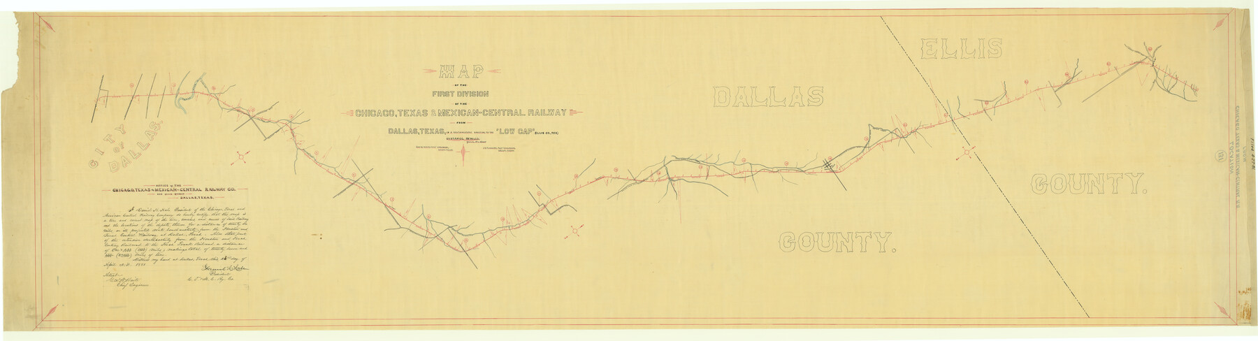
Map of the First Division of the Chicago, Texas & Mexican-Central Railway
Z-2-131
-
Map/Doc
64467
-
Collection
General Map Collection
-
Object Dates
1881/4/27 (File Date)
-
Counties
Dallas Ellis
-
Subjects
Railroads
-
Height x Width
26.1 x 96.3 inches
66.3 x 244.6 cm
-
Medium
paper, manuscript
-
Scale
1 in. = 1600 ft
-
Comments
From Dallas, in a southwesterly direction, to the 'Low Gap' in Ellis County.
-
Features
North Branch of 10 Mile Creek
Mountain Peak Road
Waxahachie Road
Lebonan Carings Road
Low Gap
Red Oak Creek
North Branch of Red Oak Creek
Dallas & Cleburne Road
Cedar Hill
South Branch of 10 Mile Creek
CT&MC
Metcalf Branch of 10 Mile Creek
Dallas, Cedar Hill & Cleburne Road
Beckley Road
Lancaster Road
Big Cedar Creek
Trinity River
H&TC
TTRR
Dallas
Part of: General Map Collection
Wise County Working Sketch Graphic Index

Print $20.00
- Digital $50.00
Wise County Working Sketch Graphic Index
1942
Size 44.9 x 37.9 inches
Map/Doc 76745
Flight Mission No. DQN-6K, Frame 71, Calhoun County

Print $20.00
- Digital $50.00
Flight Mission No. DQN-6K, Frame 71, Calhoun County
1953
Size 18.5 x 22.2 inches
Map/Doc 84443
Coleman County Working Sketch 19

Print $20.00
- Digital $50.00
Coleman County Working Sketch 19
1953
Size 18.1 x 15.4 inches
Map/Doc 68085
Anderson County Boundary File 10

Print $13.00
- Digital $50.00
Anderson County Boundary File 10
Size 16.0 x 10.2 inches
Map/Doc 49759
Edwards County Boundary File 27c

Print $29.00
- Digital $50.00
Edwards County Boundary File 27c
Size 12.8 x 8.1 inches
Map/Doc 52896
Upper Galveston Bay, Houston Ship Channel, Dollar Pt. to Atkinson I.

Print $40.00
- Digital $50.00
Upper Galveston Bay, Houston Ship Channel, Dollar Pt. to Atkinson I.
1976
Size 49.3 x 36.5 inches
Map/Doc 69897
Flight Mission No. BRE-1P, Frame 97, Nueces County

Print $20.00
- Digital $50.00
Flight Mission No. BRE-1P, Frame 97, Nueces County
1956
Size 18.3 x 22.0 inches
Map/Doc 86668
Nueces County Rolled Sketch 7

Print $20.00
- Digital $50.00
Nueces County Rolled Sketch 7
Size 37.5 x 34.6 inches
Map/Doc 9585
Hockley County Working Sketch Graphic Index

Print $20.00
- Digital $50.00
Hockley County Working Sketch Graphic Index
1954
Size 42.3 x 37.8 inches
Map/Doc 76579
Menard County Working Sketch 2

Print $20.00
- Digital $50.00
Menard County Working Sketch 2
1906
Size 17.8 x 12.5 inches
Map/Doc 70949
Hardin County Sketch File 33

Print $20.00
- Digital $50.00
Hardin County Sketch File 33
Size 25.4 x 35.4 inches
Map/Doc 11632
Edwards-Kinney County Line, Field Notes & Correspondence, 1933

Print $42.00
- Digital $50.00
Edwards-Kinney County Line, Field Notes & Correspondence, 1933
1931
Size 11.2 x 8.7 inches
Map/Doc 62881
You may also like
Kenedy County Working Sketch 1

Print $20.00
- Digital $50.00
Kenedy County Working Sketch 1
Size 31.1 x 22.0 inches
Map/Doc 70002
Burnet County Working Sketch 3

Print $20.00
- Digital $50.00
Burnet County Working Sketch 3
1953
Size 31.4 x 26.9 inches
Map/Doc 67846
Map of Hays County, Texas

Print $20.00
- Digital $50.00
Map of Hays County, Texas
1880
Size 24.3 x 21.4 inches
Map/Doc 5029
[Sketch showing H. & T. C. R. R. Co. Blk. 48, S. P. R. R. Co. Blk. I, and E. T. R. R. Co. Blk. I]
![89625, [Sketch showing H. & T. C. R. R. Co. Blk. 48, S. P. R. R. Co. Blk. I, and E. T. R. R. Co. Blk. I], Twichell Survey Records](https://historictexasmaps.com/wmedia_w700/maps/89625-1.tif.jpg)
Print $40.00
- Digital $50.00
[Sketch showing H. & T. C. R. R. Co. Blk. 48, S. P. R. R. Co. Blk. I, and E. T. R. R. Co. Blk. I]
Size 51.1 x 9.4 inches
Map/Doc 89625


Kimble County Sketch File 9a

Print $4.00
- Digital $50.00
Kimble County Sketch File 9a
Size 12.4 x 9.2 inches
Map/Doc 28929
Kinney County Working Sketch 6

Print $20.00
- Digital $50.00
Kinney County Working Sketch 6
1908
Size 19.6 x 23.9 inches
Map/Doc 70188
Property of Hobbs Trailers Manufacturing Company

Print $20.00
- Digital $50.00
Property of Hobbs Trailers Manufacturing Company
1956
Size 36.6 x 18.9 inches
Map/Doc 92733
McMullen County Working Sketch 36

Print $20.00
- Digital $50.00
McMullen County Working Sketch 36
1963
Size 40.1 x 41.5 inches
Map/Doc 70737
Working Sketch in Bailey County

Print $20.00
- Digital $50.00
Working Sketch in Bailey County
1906
Size 22.2 x 12.5 inches
Map/Doc 90184
Flight Mission No. DQN-6K, Frame 73, Calhoun County

Print $20.00
- Digital $50.00
Flight Mission No. DQN-6K, Frame 73, Calhoun County
1953
Size 18.5 x 22.1 inches
Map/Doc 84445