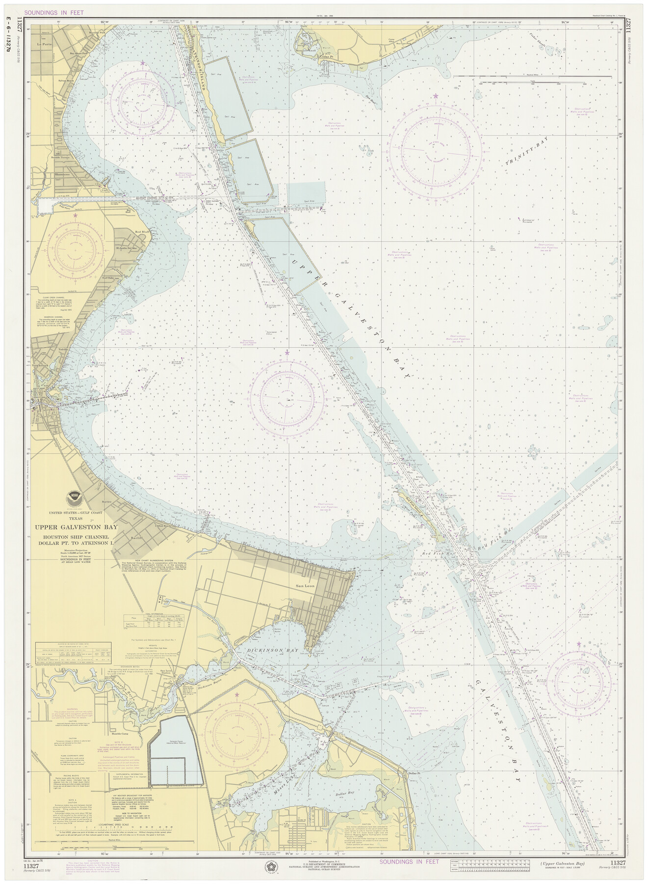
Upper Galveston Bay, Houston Ship Channel, Dollar Pt. to Atkinson I.
E.6.11327a
-
Map/Doc
69897
-
Collection
General Map Collection
-
Object Dates
4/4/1976 (Creation Date)
-
Counties
Chambers Galveston
-
Subjects
Nautical Charts
-
Height x Width
49.3 x 36.5 inches
125.2 x 92.7 cm
Part of: General Map Collection

Edwards County Working Sketch 13

Print $20.00
- Digital $50.00
Edwards County Working Sketch 13
1922
Size 18.3 x 18.4 inches
Map/Doc 68889
Kleberg County Aerial Photograph Index Sheet 7

Print $20.00
- Digital $50.00
Kleberg County Aerial Photograph Index Sheet 7
1956
Size 24.0 x 20.1 inches
Map/Doc 83724
Val Verde County Working Sketch 112

Print $40.00
- Digital $50.00
Val Verde County Working Sketch 112
1990
Size 48.2 x 30.8 inches
Map/Doc 72247
Castro County Sketch File 4m

Print $4.00
- Digital $50.00
Castro County Sketch File 4m
Size 13.6 x 8.6 inches
Map/Doc 17489
Crosby County Working Sketch 3

Print $20.00
- Digital $50.00
Crosby County Working Sketch 3
1903
Size 25.7 x 36.0 inches
Map/Doc 68437
Lee County Working Sketch 18

Print $20.00
- Digital $50.00
Lee County Working Sketch 18
1989
Size 18.3 x 17.2 inches
Map/Doc 70397
Lamb County Rolled Sketch 8

Print $20.00
- Digital $50.00
Lamb County Rolled Sketch 8
1910
Size 40.1 x 32.8 inches
Map/Doc 10728
Houston County Rolled Sketch 9

Print $20.00
- Digital $50.00
Houston County Rolled Sketch 9
1980
Size 27.5 x 26.6 inches
Map/Doc 6229
Topographical Map of the Rio Grande, Sheet No. 13

Print $20.00
- Digital $50.00
Topographical Map of the Rio Grande, Sheet No. 13
1912
Map/Doc 89537
Martin County Working Sketch 5

Print $20.00
- Digital $50.00
Martin County Working Sketch 5
1971
Size 42.9 x 31.0 inches
Map/Doc 70823
Intracoastal Waterway - Gibbstown to Port Arthur

Print $20.00
- Digital $50.00
Intracoastal Waterway - Gibbstown to Port Arthur
1961
Size 26.6 x 38.7 inches
Map/Doc 69833
You may also like
Bowie County Working Sketch 27

Print $20.00
- Digital $50.00
Bowie County Working Sketch 27
1987
Size 39.1 x 33.8 inches
Map/Doc 67431
Dawson County Sketch File C

Print $50.00
- Digital $50.00
Dawson County Sketch File C
1917
Size 14.3 x 8.8 inches
Map/Doc 20470
Motley County Sketch File 36 (S)

Print $4.00
- Digital $50.00
Motley County Sketch File 36 (S)
1893
Size 11.0 x 8.8 inches
Map/Doc 32220
Jackson County Working Sketch 5

Print $20.00
- Digital $50.00
Jackson County Working Sketch 5
1953
Size 26.2 x 26.0 inches
Map/Doc 66453
The United States

Print $20.00
- Digital $50.00
The United States
1907
Size 21.1 x 28.3 inches
Map/Doc 95859
Pecos County Sketch [University Blocks 19 and 20]
![2439, Pecos County Sketch [University Blocks 19 and 20], General Map Collection](https://historictexasmaps.com/wmedia_w700/maps/2439-1.tif.jpg)
Print $20.00
- Digital $50.00
Pecos County Sketch [University Blocks 19 and 20]
1951
Size 31.3 x 15.8 inches
Map/Doc 2439
Right of Way and Track Map International & Gt. Northern Ry. operated by the International & Gt. Northern Ry. Co., Columbia Branch Gulf Division

Print $40.00
- Digital $50.00
Right of Way and Track Map International & Gt. Northern Ry. operated by the International & Gt. Northern Ry. Co., Columbia Branch Gulf Division
1917
Size 24.8 x 56.3 inches
Map/Doc 64593
General Highway Map, Brewster County, Texas

Print $20.00
General Highway Map, Brewster County, Texas
1940
Size 18.5 x 25.2 inches
Map/Doc 79027
Bosque County Sketch File 32

Print $42.00
- Digital $50.00
Bosque County Sketch File 32
1944
Size 19.6 x 18.6 inches
Map/Doc 10938
Hood County Working Sketch 11

Print $20.00
- Digital $50.00
Hood County Working Sketch 11
1976
Size 19.7 x 25.2 inches
Map/Doc 66205
Erath County Working Sketch 39

Print $20.00
- Digital $50.00
Erath County Working Sketch 39
1976
Size 26.9 x 28.0 inches
Map/Doc 69120
[Surveys along the Salado and Lampasas Rivers and Saltillo Creek]
![82159, [Surveys along the Salado and Lampasas Rivers and Saltillo Creek], General Map Collection](https://historictexasmaps.com/wmedia_w700/maps/82159.tif.jpg)
Print $2.00
- Digital $50.00
[Surveys along the Salado and Lampasas Rivers and Saltillo Creek]
1845
Size 13.1 x 7.7 inches
Map/Doc 82159