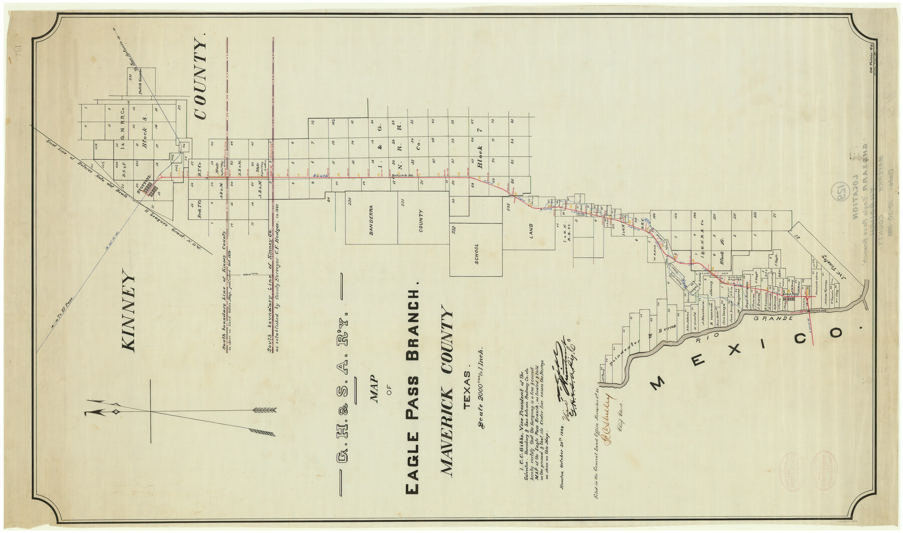
Galveston, Harrisburg & San Antonio Railway, Map of Eagle Pass Branch
Z-2-129
-
Map/Doc
64462
-
Collection
General Map Collection
-
Object Dates
1888/11/3 (File Date)
1888 (Creation Date)
-
Counties
Maverick Kinney
-
Subjects
Railroads
-
Height x Width
42.7 x 25.8 inches
108.5 x 65.5 cm
-
Medium
paper, manuscript
-
Scale
2000 var. = 1 inch
-
Features
GH&SA
Spofford
Road to El Paso
Road to San Antonio
Elm Creek
Eagle Pass
Rio Grande
Part of: General Map Collection
Haskell County Boundary File 4a

Print $62.00
- Digital $50.00
Haskell County Boundary File 4a
Size 9.0 x 4.5 inches
Map/Doc 54545
Duval County Working Sketch Graphic Index, Sheet 2 (Sketches 21 to Most Recent)

Print $20.00
- Digital $50.00
Duval County Working Sketch Graphic Index, Sheet 2 (Sketches 21 to Most Recent)
1934
Size 47.8 x 29.3 inches
Map/Doc 76528
Duval County Working Sketch 56

Print $20.00
- Digital $50.00
Duval County Working Sketch 56
1989
Size 26.7 x 27.2 inches
Map/Doc 68780
Jefferson County Rolled Sketch 31

Print $425.00
- Digital $50.00
Jefferson County Rolled Sketch 31
1955
Size 10.1 x 15.3 inches
Map/Doc 46323
Presidio County Sketch File 92

Print $10.00
- Digital $50.00
Presidio County Sketch File 92
1958
Size 11.2 x 8.8 inches
Map/Doc 34765
Lampasas County Boundary File 1

Print $4.00
- Digital $50.00
Lampasas County Boundary File 1
Size 10.2 x 8.2 inches
Map/Doc 56093
Flight Mission No. CGI-3N, Frame 179, Cameron County

Print $20.00
- Digital $50.00
Flight Mission No. CGI-3N, Frame 179, Cameron County
1954
Size 18.6 x 22.2 inches
Map/Doc 84643
Liberty County Working Sketch 28

Print $20.00
- Digital $50.00
Liberty County Working Sketch 28
1942
Size 22.4 x 23.2 inches
Map/Doc 70487
Garza County Sketch File C

Print $22.00
- Digital $50.00
Garza County Sketch File C
1900
Size 18.0 x 10.8 inches
Map/Doc 24013
Orange County Working Sketch 1

Print $20.00
- Digital $50.00
Orange County Working Sketch 1
1914
Size 16.1 x 18.2 inches
Map/Doc 71333
Jeff Davis County Working Sketch Graphic Index - east part

Print $20.00
- Digital $50.00
Jeff Davis County Working Sketch Graphic Index - east part
1977
Size 46.6 x 36.8 inches
Map/Doc 76592
Jasper County Rolled Sketch 8

Print $20.00
- Digital $50.00
Jasper County Rolled Sketch 8
Size 17.7 x 12.0 inches
Map/Doc 6356
You may also like
Presidio County Sketch File 64a

Print $4.00
- Digital $50.00
Presidio County Sketch File 64a
1939
Size 11.3 x 8.8 inches
Map/Doc 34652
Montague County Rolled Sketch 1

Print $20.00
- Digital $50.00
Montague County Rolled Sketch 1
Size 31.7 x 26.9 inches
Map/Doc 6786
Upton County Sketch File 7

Print $4.00
- Digital $50.00
Upton County Sketch File 7
Size 14.4 x 8.9 inches
Map/Doc 38820
Terrell County Sketch File 25A

Print $20.00
- Digital $50.00
Terrell County Sketch File 25A
1890
Size 16.9 x 21.5 inches
Map/Doc 12424
Medina County Working Sketch 7

Print $20.00
- Digital $50.00
Medina County Working Sketch 7
1952
Size 26.3 x 28.5 inches
Map/Doc 70922
Atascosa County Rolled Sketch 24

Print $20.00
- Digital $50.00
Atascosa County Rolled Sketch 24
Size 38.3 x 45.2 inches
Map/Doc 5101
Callahan County Rolled Sketch 26

Print $20.00
- Digital $50.00
Callahan County Rolled Sketch 26
2010
Size 30.6 x 24.6 inches
Map/Doc 93453
The Republic County of Matagorda. September 17, 1838

Print $20.00
The Republic County of Matagorda. September 17, 1838
2020
Size 21.0 x 21.7 inches
Map/Doc 96217

Shelby County

Print $40.00
- Digital $50.00
Shelby County
1897
Size 43.9 x 49.3 inches
Map/Doc 16814
Navigation Maps of Gulf Intracoastal Waterway, Port Arthur to Brownsville, Texas

Print $4.00
- Digital $50.00
Navigation Maps of Gulf Intracoastal Waterway, Port Arthur to Brownsville, Texas
1951
Size 16.7 x 21.5 inches
Map/Doc 65424
Flight Mission No. CLL-3N, Frame 6, Willacy County

Print $20.00
- Digital $50.00
Flight Mission No. CLL-3N, Frame 6, Willacy County
1954
Size 18.5 x 22.2 inches
Map/Doc 87072