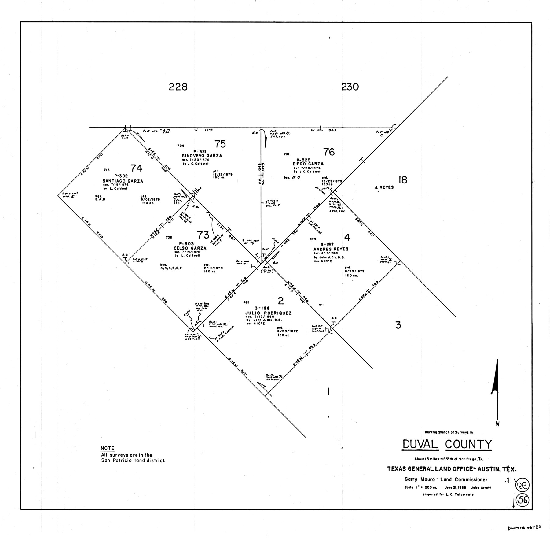
Duval County Working Sketch 56
-
Map/Doc
68780
-
Collection
General Map Collection
-
Object Dates
6/21/1989 (Creation Date)
-
People and Organizations
Jake Arrott (Draftsman)
-
Counties
Duval
-
Subjects
Surveying Working Sketch
-
Height x Width
26.7 x 27.2 inches
67.8 x 69.1 cm
-
Scale
1" = 200 varas
Part of: General Map Collection
Polk County Rolled Sketch FD

Print $40.00
- Digital $50.00
Polk County Rolled Sketch FD
Size 99.8 x 38.2 inches
Map/Doc 9754
Bee County Sketch File 8

Print $8.00
- Digital $50.00
Bee County Sketch File 8
1874
Size 12.4 x 8.0 inches
Map/Doc 14279
San Luis Pass to East Matagorda Bay

Print $40.00
- Digital $50.00
San Luis Pass to East Matagorda Bay
1991
Size 35.0 x 48.8 inches
Map/Doc 69972

Map of El Paso County

Print $20.00
- Digital $50.00
Map of El Paso County
1888
Size 47.1 x 39.5 inches
Map/Doc 4942
Armstrong County Working Sketch 4

Print $20.00
- Digital $50.00
Armstrong County Working Sketch 4
1918
Size 23.9 x 32.0 inches
Map/Doc 67235
Township No. 6 South Range No. 9 West of the Indian Meridian

Print $20.00
- Digital $50.00
Township No. 6 South Range No. 9 West of the Indian Meridian
1874
Size 19.2 x 24.5 inches
Map/Doc 75166
Pecos County Rolled Sketch 163

Print $20.00
- Digital $50.00
Pecos County Rolled Sketch 163
Size 28.2 x 23.9 inches
Map/Doc 7286
Edwards County Working Sketch 81

Print $40.00
- Digital $50.00
Edwards County Working Sketch 81
1964
Size 61.4 x 39.6 inches
Map/Doc 68957
Midland County Boundary File 2

Print $24.00
- Digital $50.00
Midland County Boundary File 2
Size 8.9 x 5.5 inches
Map/Doc 57162
Lampasas County Working Sketch 20, revised

Print $20.00
- Digital $50.00
Lampasas County Working Sketch 20, revised
1981
Size 27.1 x 34.5 inches
Map/Doc 70298
Map of Navarro County

Print $20.00
- Digital $50.00
Map of Navarro County
1872
Size 17.6 x 22.6 inches
Map/Doc 3911
You may also like
Jones County Sketch File 16

Print $20.00
- Digital $50.00
Jones County Sketch File 16
1945
Size 23.7 x 19.0 inches
Map/Doc 11901
Aransas County Rolled Sketch 9

Print $40.00
- Digital $50.00
Aransas County Rolled Sketch 9
1955
Size 85.3 x 41.9 inches
Map/Doc 8409
El Paso County Boundary File 1

Print $48.00
- Digital $50.00
El Paso County Boundary File 1
Size 12.3 x 35.0 inches
Map/Doc 53015
W. S. Mabry Land Corners and Connections, Potter County

Print $20.00
- Digital $50.00
W. S. Mabry Land Corners and Connections, Potter County
Size 22.6 x 17.5 inches
Map/Doc 91806
Map of Padre Island

Print $40.00
- Digital $50.00
Map of Padre Island
Size 74.6 x 22.8 inches
Map/Doc 76020
Map of Fannin County

Print $20.00
- Digital $50.00
Map of Fannin County
1866
Size 21.9 x 18.1 inches
Map/Doc 3534
Crane County Sketch File 1

Print $20.00
- Digital $50.00
Crane County Sketch File 1
Size 44.8 x 14.6 inches
Map/Doc 10343
Kent County Working Sketch 23

Print $20.00
- Digital $50.00
Kent County Working Sketch 23
1987
Size 47.2 x 43.0 inches
Map/Doc 70030
Coast Chart No. 210 Aransas Pass and Corpus Christi Bay with the coast to latitude 27° 12' Texas

Print $20.00
- Digital $50.00
Coast Chart No. 210 Aransas Pass and Corpus Christi Bay with the coast to latitude 27° 12' Texas
1913
Size 27.9 x 18.3 inches
Map/Doc 72806
Webb County Sketch File 5-1

Print $4.00
- Digital $50.00
Webb County Sketch File 5-1
Size 3.7 x 12.6 inches
Map/Doc 39733
Stonewall County

Print $20.00
- Digital $50.00
Stonewall County
1879
Size 22.7 x 19.1 inches
Map/Doc 4058
General Highway Map, Upshur County, Gregg County, Texas

Print $20.00
General Highway Map, Upshur County, Gregg County, Texas
1939
Size 24.9 x 18.6 inches
Map/Doc 79105