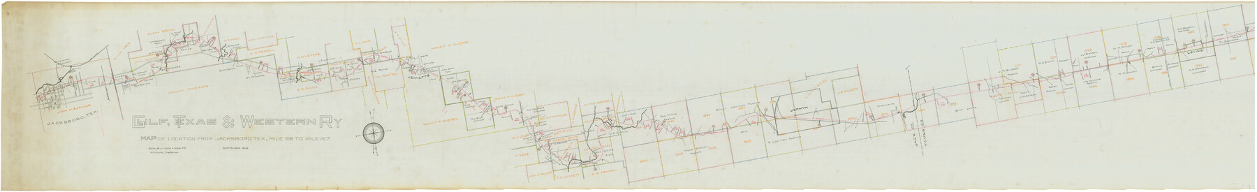
Gulf, Texas & Western Railway
Z-2-113
-
Map/Doc
64430
-
Collection
General Map Collection
-
Object Dates
9/1909 (Creation Date)
-
People and Organizations
Will S. Clark (Draftsman)
-
Counties
Jack Young
-
Subjects
Railroads
-
Height x Width
18.5 x 121.0 inches
47.0 x 307.3 cm
-
Medium
linen, manuscript
-
Scale
1" = 1000 ft.
-
Comments
Map of location from Jacksboro West through Young County, Mile 96 to Mile 157. Segment 1; see counter no. 64431 for segment 2.
-
Features
Flour Mill
Graham and Markler Road
Cameron Creek
O. Lovings Ranch House
Gertrude & Graham Road
West Fork of North Creek
North Creek
Jeanette
Cleveland Creek
Halls Branch
Little Cleveland Creek
CRI&T
GT&W
Oil Mill
Ice & Light Co.
R.I. Freight Station
R.I. Passenger Station
Mill Street
Court House
Main Street
Church Street
Archer Street
Belknap Street
Los Creek
Related maps
Gulf, Texas & Western Railway

Print $40.00
- Digital $50.00
Gulf, Texas & Western Railway
1909
Size 18.7 x 103.5 inches
Map/Doc 64431
Part of: General Map Collection
Cooke County Sketch File 27

Print $24.00
- Digital $50.00
Cooke County Sketch File 27
Size 9.8 x 8.5 inches
Map/Doc 19279
Pecos County Working Sketch 76

Print $20.00
- Digital $50.00
Pecos County Working Sketch 76
1959
Size 26.7 x 40.1 inches
Map/Doc 71548
Brown County Working Sketch 10

Print $20.00
- Digital $50.00
Brown County Working Sketch 10
1982
Size 25.3 x 25.5 inches
Map/Doc 67775
Dickens County Sketch File 33

Print $10.00
- Digital $50.00
Dickens County Sketch File 33
1947
Size 14.5 x 9.1 inches
Map/Doc 21025
Jefferson County Rolled Sketch 27

Print $20.00
- Digital $50.00
Jefferson County Rolled Sketch 27
1948
Size 24.2 x 46.6 inches
Map/Doc 9292
Pecos County Sketch File 53

Print $20.00
- Digital $50.00
Pecos County Sketch File 53
Size 18.0 x 38.9 inches
Map/Doc 10569
Zapata County Working Sketch 24

Print $20.00
- Digital $50.00
Zapata County Working Sketch 24
1992
Size 28.2 x 23.9 inches
Map/Doc 62075
Aransas County Rolled Sketch 27D

Print $20.00
- Digital $50.00
Aransas County Rolled Sketch 27D
1930
Size 40.5 x 40.2 inches
Map/Doc 8418
Galveston/Galveston Island, Texas

Galveston/Galveston Island, Texas
Size 18.4 x 24.2 inches
Map/Doc 94345
Jeff Davis County Working Sketch 9

Print $20.00
- Digital $50.00
Jeff Davis County Working Sketch 9
1943
Size 28.5 x 27.3 inches
Map/Doc 66504
Hardin County Working Sketch 30

Print $20.00
- Digital $50.00
Hardin County Working Sketch 30
1967
Size 24.6 x 20.3 inches
Map/Doc 63428
Flight Mission No. CUG-3P, Frame 137, Kleberg County

Print $20.00
- Digital $50.00
Flight Mission No. CUG-3P, Frame 137, Kleberg County
1956
Size 18.4 x 22.2 inches
Map/Doc 86272
You may also like
Township No. 4 South Range No. 17 West of the Indian Meridian

Print $20.00
- Digital $50.00
Township No. 4 South Range No. 17 West of the Indian Meridian
1875
Size 19.2 x 24.4 inches
Map/Doc 75164
Duval County Boundary File 1c

Print $12.00
- Digital $50.00
Duval County Boundary File 1c
Size 12.9 x 8.3 inches
Map/Doc 52693
Flight Mission No. DQN-6K, Frame 74, Calhoun County

Print $20.00
- Digital $50.00
Flight Mission No. DQN-6K, Frame 74, Calhoun County
1953
Size 18.5 x 22.2 inches
Map/Doc 84446
Map of Young County

Print $20.00
- Digital $50.00
Map of Young County
Size 25.6 x 29.8 inches
Map/Doc 92023
Howard County Working Sketch 7a

Print $40.00
- Digital $50.00
Howard County Working Sketch 7a
1950
Size 81.9 x 24.7 inches
Map/Doc 66273
Shelby County Working Sketch 29b

Print $20.00
- Digital $50.00
Shelby County Working Sketch 29b
2000
Size 25.2 x 37.8 inches
Map/Doc 63884
Loving County Rolled Sketch 1A

Print $40.00
- Digital $50.00
Loving County Rolled Sketch 1A
Size 77.9 x 42.9 inches
Map/Doc 9461
Matagorda Light to Aransas Pass

Print $20.00
- Digital $50.00
Matagorda Light to Aransas Pass
1974
Size 36.5 x 45.3 inches
Map/Doc 73401
Edwards County Working Sketch 114

Print $20.00
- Digital $50.00
Edwards County Working Sketch 114
1972
Size 33.6 x 33.1 inches
Map/Doc 68990
Flight Mission No. BRA-8M, Frame 120, Jefferson County

Print $20.00
- Digital $50.00
Flight Mission No. BRA-8M, Frame 120, Jefferson County
1953
Size 18.6 x 22.5 inches
Map/Doc 85616
Map of Refugio District

Print $20.00
- Digital $50.00
Map of Refugio District
1850
Size 22.6 x 25.1 inches
Map/Doc 1959
Kinney County Sketch File 33

Print $20.00
- Digital $50.00
Kinney County Sketch File 33
1939
Size 18.1 x 22.8 inches
Map/Doc 11948