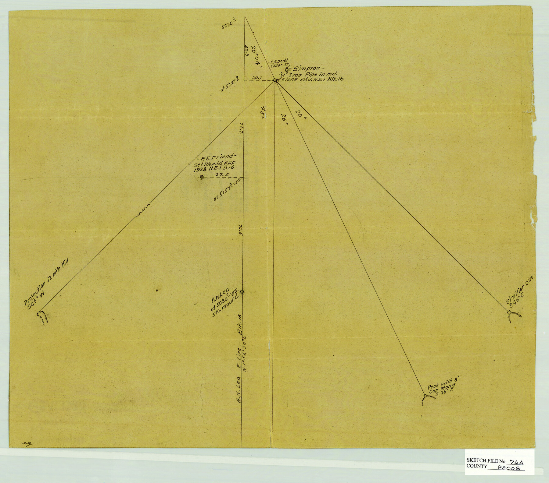
Pecos County Sketch File 76A
Sketch Showing the NE Corner of Block 16, University Land, Pecos County, Texas
-
Map/Doc
12182
-
Collection
General Map Collection
-
Object Dates
10/27/1945 (File Date)
-
People and Organizations
Dod (Surveyor/Engineer)
Simpson (Surveyor/Engineer)
A.N. Lea (Surveyor/Engineer)
Frank F. Friend (Surveyor/Engineer)
-
Counties
Pecos
-
Subjects
Surveying Sketch File
-
Height x Width
16.1 x 18.3 inches
40.9 x 46.5 cm
-
Medium
paper, manuscript
Part of: General Map Collection
United States

Print $40.00
- Digital $50.00
United States
1961
Size 55.0 x 81.2 inches
Map/Doc 75922
Reagan County Working Sketch 25

Print $20.00
- Digital $50.00
Reagan County Working Sketch 25
1958
Size 45.8 x 42.8 inches
Map/Doc 71867
Sutton County Rolled Sketch 41

Print $20.00
- Digital $50.00
Sutton County Rolled Sketch 41
1938
Size 34.5 x 23.3 inches
Map/Doc 7883
Lampasas County Rolled Sketch 4

Print $20.00
- Digital $50.00
Lampasas County Rolled Sketch 4
2001
Size 27.1 x 38.5 inches
Map/Doc 6566
Flight Mission No. BQY-4M, Frame 63, Harris County

Print $20.00
- Digital $50.00
Flight Mission No. BQY-4M, Frame 63, Harris County
1953
Size 18.7 x 22.4 inches
Map/Doc 85272
Rusk County Sketch File 30

Print $10.00
Rusk County Sketch File 30
1949
Size 11.3 x 8.9 inches
Map/Doc 35558
Hidalgo County Working Sketch 1

Print $20.00
- Digital $50.00
Hidalgo County Working Sketch 1
1939
Size 24.8 x 21.4 inches
Map/Doc 66178
Williamson County Working Sketch 4

Print $20.00
- Digital $50.00
Williamson County Working Sketch 4
1919
Size 23.7 x 19.4 inches
Map/Doc 72564
Wilbarger County Sketch File 3

Print $26.00
- Digital $50.00
Wilbarger County Sketch File 3
Size 7.4 x 13.9 inches
Map/Doc 40166
Nueces County Rolled Sketch 95

Print $20.00
- Digital $50.00
Nueces County Rolled Sketch 95
1983
Size 18.2 x 24.7 inches
Map/Doc 7052
Presidio County Rolled Sketch 40

Print $20.00
- Digital $50.00
Presidio County Rolled Sketch 40
1907
Size 16.5 x 21.5 inches
Map/Doc 7337
Shackelford County Sketch File 6

Print $20.00
- Digital $50.00
Shackelford County Sketch File 6
Size 14.8 x 24.5 inches
Map/Doc 81981
You may also like
[H. & G. N. Block 1, G. C. & S. F. Block Z]
![91168, [H. & G. N. Block 1, G. C. & S. F. Block Z], Twichell Survey Records](https://historictexasmaps.com/wmedia_w700/maps/91168-1.tif.jpg)
Print $3.00
- Digital $50.00
[H. & G. N. Block 1, G. C. & S. F. Block Z]
Size 16.8 x 10.5 inches
Map/Doc 91168
[Sections 58-70, I. & G. N. Block 1, Runnels County School Land and part of Block 194]
![91632, [Sections 58-70, I. & G. N. Block 1, Runnels County School Land and part of Block 194], Twichell Survey Records](https://historictexasmaps.com/wmedia_w700/maps/91632-1.tif.jpg)
Print $20.00
- Digital $50.00
[Sections 58-70, I. & G. N. Block 1, Runnels County School Land and part of Block 194]
Size 23.9 x 20.9 inches
Map/Doc 91632
Map of Texas in 1830 Showing Spanish Colonies

Print $20.00
- Digital $50.00
Map of Texas in 1830 Showing Spanish Colonies
Size 41.1 x 42.0 inches
Map/Doc 73588
Dimmit County Rolled Sketch 19

Print $20.00
- Digital $50.00
Dimmit County Rolled Sketch 19
1990
Size 45.4 x 41.7 inches
Map/Doc 8799
Nueces County, Texas

Print $20.00
- Digital $50.00
Nueces County, Texas
1879
Size 29.3 x 40.0 inches
Map/Doc 590
Hutchinson County Rolled Sketch 43

Print $40.00
- Digital $50.00
Hutchinson County Rolled Sketch 43
1992
Size 41.3 x 50.0 inches
Map/Doc 6314
Brazoria County Working Sketch 7

Print $20.00
- Digital $50.00
Brazoria County Working Sketch 7
1930
Size 40.9 x 21.1 inches
Map/Doc 67492
Dimmit County Sketch File 23

Print $38.00
- Digital $50.00
Dimmit County Sketch File 23
1894
Size 10.0 x 11.8 inches
Map/Doc 21133
Sketch Showing Beach Groins 6th St to 39th St - Galveston, Tex.

Print $20.00
- Digital $50.00
Sketch Showing Beach Groins 6th St to 39th St - Galveston, Tex.
1928
Size 21.0 x 36.4 inches
Map/Doc 73626
Llano County Sketch File 7

Print $4.00
- Digital $50.00
Llano County Sketch File 7
Size 6.6 x 7.3 inches
Map/Doc 30362
Erath County Sketch File 3b

Print $4.00
- Digital $50.00
Erath County Sketch File 3b
Size 10.3 x 8.3 inches
Map/Doc 22257
Duval County Sketch File 8

Print $6.00
- Digital $50.00
Duval County Sketch File 8
1869
Size 14.1 x 11.3 inches
Map/Doc 21296