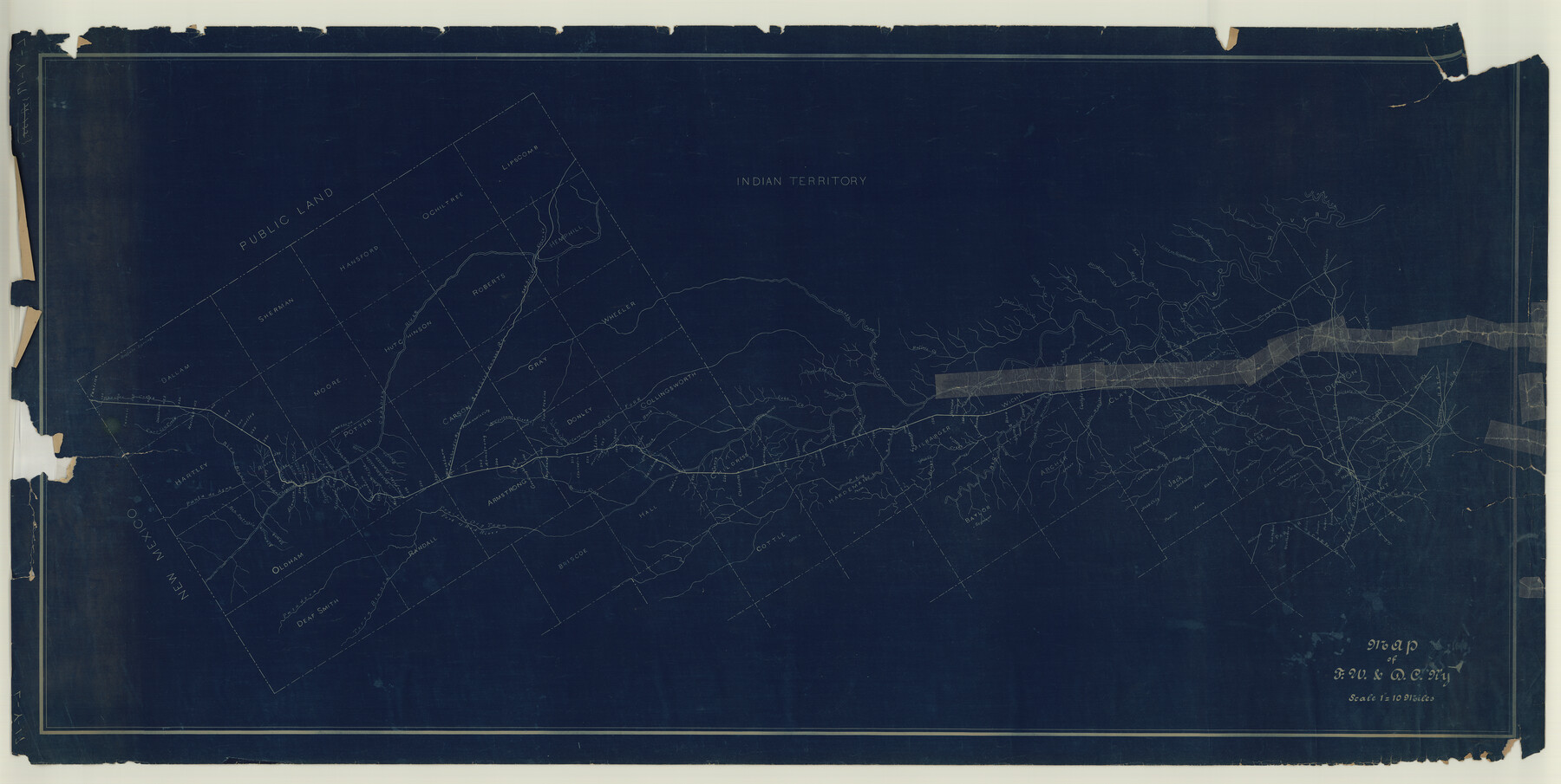
Map of Fort Worth & Denver City Railway
Z-2-106
-
Map/Doc
64416
-
Collection
General Map Collection
-
Object Dates
1880 (Creation Date)
-
Counties
Tarrant Dallas
-
Subjects
Railroads
-
Height x Width
25.3 x 50.3 inches
64.3 x 127.8 cm
-
Medium
blueprint/diazo
-
Scale
1"=10 Miles
-
Comments
From Dallas to New Mexico Line.
-
Features
Parker Creek
Rita Creek
Pascosa Creek
Tascosa
Cotton Wood Creek
India Creek
Correll Creek
Sierra de la Cruz Creek
Echo Creek
John Ray Creek
Grapevine Creek
Tecovas Creek
Home Creek
Amarillo Creek
East Amarillo Creek
Piedrosa Creek
Bonita Creek
Field
Washburn
PR
SKR
Red Deer Creek
Clear Creek
McClellans Creek
Goodnight
Southard
Mulberry Creek
Allen Creek
Carrol Creek
Clarendon
Salt Fork of Red River
Adieu
Archer
Arlington
Barr's Creek
Best
Beau
Beaver Creek
Benbrook
Bethville
Big Beaver Creek
Bowie
Briar Creek
Buck Creek
Buffalo Creek
Burke
Butter Creek
Cache Creek
Carlos
Camp Creek
Carey
Chico
Childress
Chillicothe
China Creek
Cottondale
Cowen
Crafton
Crowley
Daggett
Dallas
Deep Red Creek
Denton
Denton Creek
Eagle Ford
East Dallas
East Fork of Red River
Elkhorn
Ennis Creek
Ft. Worth
FW&RG
Gainesville
GC&SF
Gertrude
Giles
Grand Prairie
Grapevine
Greenback Creek
Gypsum
Gypsum Creek
H&TC
Hadley
Harrold
Hickory Creek
Holliday Creek
Initia Monument
Iowa Point
Jacksboro
Kirkland
Lake Creek
Lambert
Lebo Creek
Lelia
Lilly Creek
Little Elm Creek
Little Wichita River
Lost on Simmens Creek
Lotta
Marysville
Minnai Creek
M&P
Montague
Mud Creek
Newlin
North Fork of Red River
Oak Grove
Otta
Paulino
Pease
Pease River
Pecan Creek
Quanah
Red Creek
Red River
Riverland
Roland
Rowe
Salisbury
Seymour
Springs Creek
Stinking Creek
SA&T
Sunset
Turkey Creek
Vernon
Walnut Bayou
Wanderers Creek
Washita Creek
Weatherford
Webb City
West Cache Creek
West Fork of Trinity River
Whitesboro
Wichita Falls
Wichita River
Willow Point
Worley Lake
FW&DC
Buffalo Springs
Perico Creek
Carrizo Creek
Rita Blanca
Punta de Agua
Rio Patricio
Skunk Creek
Alamosita Creek
Las Ruedas Creek
Canadian River
Paladora River
Terra Blanca River
Prairie Dog Town Fork of Red River
Cheyenne Creek
Part of: General Map Collection
Fort Bend County Boundary File 1

Print $80.00
- Digital $50.00
Fort Bend County Boundary File 1
Size 25.0 x 69.7 inches
Map/Doc 53553
Edwards County Rolled Sketch 20

Print $20.00
- Digital $50.00
Edwards County Rolled Sketch 20
1947
Size 31.6 x 40.4 inches
Map/Doc 8844
Lynn County Working Sketch 1

Print $20.00
- Digital $50.00
Lynn County Working Sketch 1
1945
Size 17.2 x 14.0 inches
Map/Doc 70671
Kerr County Sketch File 1b

Print $2.00
- Digital $50.00
Kerr County Sketch File 1b
Size 8.1 x 10.2 inches
Map/Doc 28850
Crockett County Rolled Sketch 88N

Print $89.00
- Digital $50.00
Crockett County Rolled Sketch 88N
1973
Size 10.6 x 15.5 inches
Map/Doc 44132
Newton County Sketch File 42

Print $39.00
- Digital $50.00
Newton County Sketch File 42
1936
Size 13.2 x 8.7 inches
Map/Doc 32425
Andrews County Rolled Sketch 42

Print $20.00
- Digital $50.00
Andrews County Rolled Sketch 42
Size 27.3 x 36.0 inches
Map/Doc 77182
Wharton County Sketch File A3

Print $26.00
- Digital $50.00
Wharton County Sketch File A3
1899
Size 18.2 x 18.6 inches
Map/Doc 12671
Reagan County Rolled Sketch 9

Print $20.00
- Digital $50.00
Reagan County Rolled Sketch 9
1937
Size 29.7 x 30.9 inches
Map/Doc 7437
Laguna Madre, T-9209

Print $20.00
- Digital $50.00
Laguna Madre, T-9209
Size 34.0 x 30.8 inches
Map/Doc 73600
Hudspeth County Working Sketch 39

Print $20.00
- Digital $50.00
Hudspeth County Working Sketch 39
1980
Size 37.1 x 37.0 inches
Map/Doc 66324
Fort Bend County Sketch File 28

Print $40.00
- Digital $50.00
Fort Bend County Sketch File 28
Size 13.7 x 8.6 inches
Map/Doc 22979
You may also like
Baylor County Sketch File 12f

Print $12.00
- Digital $50.00
Baylor County Sketch File 12f
1900
Size 14.4 x 9.0 inches
Map/Doc 14164
Panola County Working Sketch 14

Print $40.00
- Digital $50.00
Panola County Working Sketch 14
1945
Map/Doc 71423
Flight Mission No. DIX-5P, Frame 151, Aransas County

Print $20.00
- Digital $50.00
Flight Mission No. DIX-5P, Frame 151, Aransas County
1956
Size 17.8 x 18.2 inches
Map/Doc 83813
Pecos County Rolled Sketch 182

Print $20.00
- Digital $50.00
Pecos County Rolled Sketch 182
Size 21.4 x 33.9 inches
Map/Doc 7301
[G. C. & S. F. Ry. Northern-Division, Alignment and Right of Way Map, Weatherford Branch, Johnson and Hood Counties, Texas]
![64648, [G. C. & S. F. Ry. Northern-Division, Alignment and Right of Way Map, Weatherford Branch, Johnson and Hood Counties, Texas], General Map Collection](https://historictexasmaps.com/wmedia_w700/maps/64648.tif.jpg)
Print $40.00
- Digital $50.00
[G. C. & S. F. Ry. Northern-Division, Alignment and Right of Way Map, Weatherford Branch, Johnson and Hood Counties, Texas]
1935
Size 37.4 x 120.9 inches
Map/Doc 64648
Presidio County Rolled Sketch 115

Print $20.00
- Digital $50.00
Presidio County Rolled Sketch 115
1980
Size 19.3 x 22.2 inches
Map/Doc 7391
Denton County Texas

Print $20.00
- Digital $50.00
Denton County Texas
1896
Size 18.4 x 31.6 inches
Map/Doc 4530
Flight Mission No. BRA-9M, Frame 62, Jefferson County

Print $20.00
- Digital $50.00
Flight Mission No. BRA-9M, Frame 62, Jefferson County
1953
Size 18.7 x 22.3 inches
Map/Doc 85645
Hockley County Working Sketch 4

Print $40.00
- Digital $50.00
Hockley County Working Sketch 4
1973
Size 38.7 x 52.3 inches
Map/Doc 66194
Orange County NRC Article 33.136 Sketch 3

Print $16.00
- Digital $50.00
Orange County NRC Article 33.136 Sketch 3
2011
Size 11.0 x 8.5 inches
Map/Doc 93267
Plat showing surveys made for N. Vasquez, Sr. of Casa Piedra, Texas in Block 312, T. C. Ry. Co.

Print $20.00
- Digital $50.00
Plat showing surveys made for N. Vasquez, Sr. of Casa Piedra, Texas in Block 312, T. C. Ry. Co.
1947
Size 16.5 x 22.3 inches
Map/Doc 2062
Navigation Maps of Gulf Intracoastal Waterway, Port Arthur to Brownsville, Texas

Print $4.00
- Digital $50.00
Navigation Maps of Gulf Intracoastal Waterway, Port Arthur to Brownsville, Texas
1951
Size 16.7 x 21.6 inches
Map/Doc 65426