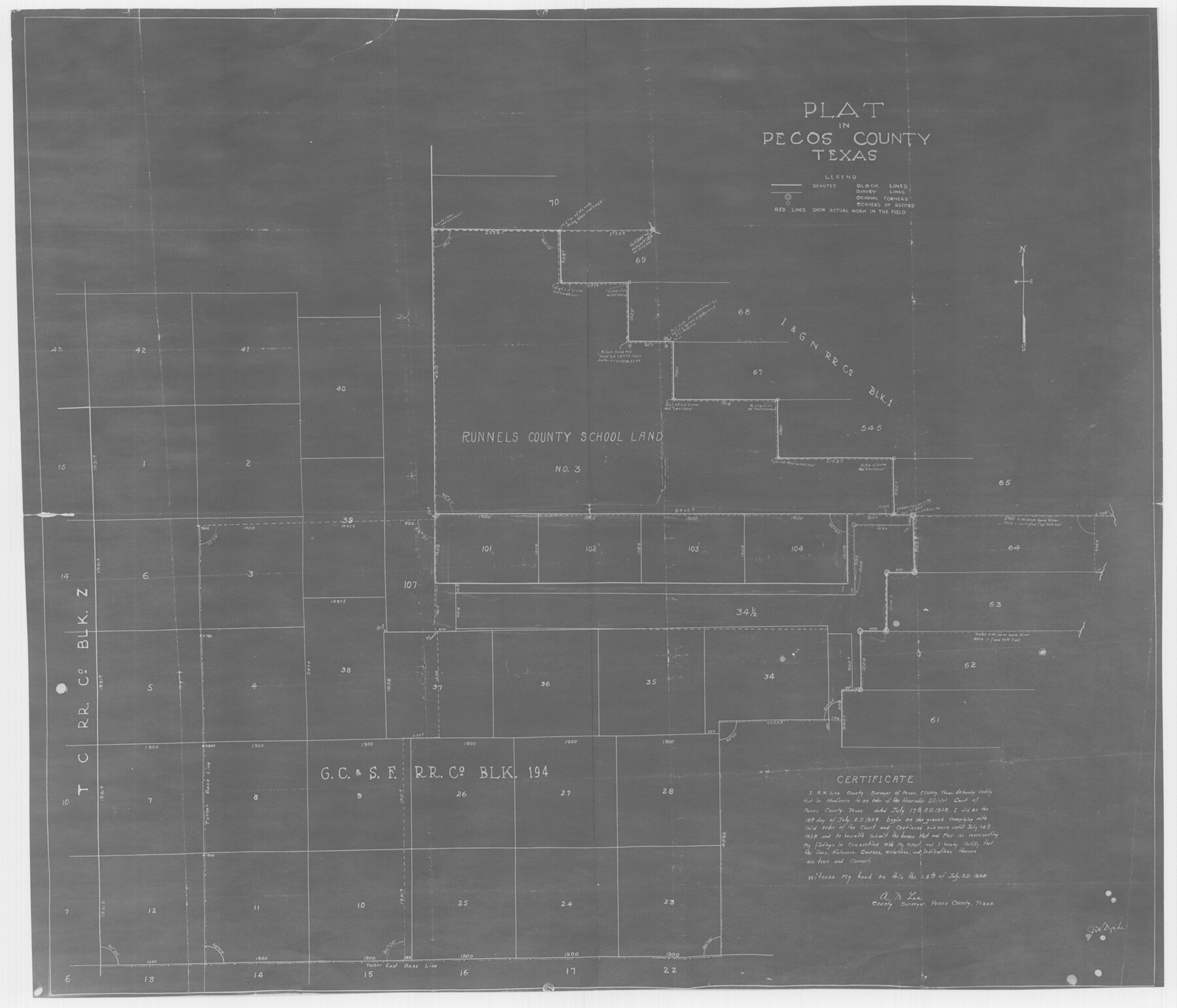
Vacancy Application - John H. Tyler near T.C. Ry. Co. Block 1 Surveys 101, 102, 103, & 104. Letters and Maps, Pecos County
N-1-1
N-1-1
-
Map/Doc
2048
-
Collection
General Map Collection
-
Object Dates
1934 (Creation Date)
-
People and Organizations
General Land Office (Publisher)
-
Counties
Pecos
-
Subjects
Legal
-
Height x Width
18.1 x 21.1 inches
46.0 x 53.6 cm
-
Medium
multi-page, multi-format
Part of: General Map Collection
Edwards County Sketch File 4

Print $5.00
- Digital $50.00
Edwards County Sketch File 4
Size 9.5 x 11.0 inches
Map/Doc 21680
Leon County Sketch File 10

Print $64.00
- Digital $50.00
Leon County Sketch File 10
1871
Size 10.6 x 15.7 inches
Map/Doc 29731
Map of Hemisfair '68 and Downtown San Antonio compliments of the Pearl Brewing Company

Print $3.00
- Digital $50.00
Map of Hemisfair '68 and Downtown San Antonio compliments of the Pearl Brewing Company
1968
Size 5.9 x 11.3 inches
Map/Doc 94792
Flight Mission No. DCL-6C, Frame 173, Kenedy County

Print $20.00
- Digital $50.00
Flight Mission No. DCL-6C, Frame 173, Kenedy County
1943
Size 18.6 x 22.4 inches
Map/Doc 85985
Texas Official Travel Map

Digital $50.00
Texas Official Travel Map
Size 33.4 x 36.4 inches
Map/Doc 94424
Topographical Map of the Rio Grande, Sheet No. 24

Print $20.00
- Digital $50.00
Topographical Map of the Rio Grande, Sheet No. 24
1912
Map/Doc 89548
Galveston County Sketch File 73h

Print $20.00
- Digital $50.00
Galveston County Sketch File 73h
Size 29.4 x 36.8 inches
Map/Doc 10461
Val Verde Co.

Print $20.00
- Digital $50.00
Val Verde Co.
1908
Size 39.1 x 37.7 inches
Map/Doc 63102
Index sheet to accompany map of survey for connecting the inland waters along margin of the Gulf of Mexico from Donaldsonville in Louisiana to the Rio Grande River in Texas

Print $20.00
- Digital $50.00
Index sheet to accompany map of survey for connecting the inland waters along margin of the Gulf of Mexico from Donaldsonville in Louisiana to the Rio Grande River in Texas
Size 18.2 x 27.5 inches
Map/Doc 72691
Dickens County Working Sketch 6

Print $20.00
- Digital $50.00
Dickens County Working Sketch 6
1932
Size 23.7 x 30.7 inches
Map/Doc 68654
[Sketch for Mineral Application 15559 - Hutchinson County, Canadian River]
![65680, [Sketch for Mineral Application 15559 - Hutchinson County, Canadian River], General Map Collection](https://historictexasmaps.com/wmedia_w700/maps/65680-1.tif.jpg)
Print $20.00
- Digital $50.00
[Sketch for Mineral Application 15559 - Hutchinson County, Canadian River]
1926
Size 12.0 x 13.2 inches
Map/Doc 65680
Brazoria County Rolled Sketch 35

Print $40.00
- Digital $50.00
Brazoria County Rolled Sketch 35
1934
Size 32.7 x 60.0 inches
Map/Doc 8459
You may also like
[Map of Oldham County]
![91456, [Map of Oldham County], Twichell Survey Records](https://historictexasmaps.com/wmedia_w700/maps/91456-1.tif.jpg)
Print $20.00
- Digital $50.00
[Map of Oldham County]
Size 28.4 x 20.5 inches
Map/Doc 91456
Fayette County Boundary File 3

Print $29.00
- Digital $50.00
Fayette County Boundary File 3
Size 14.4 x 9.0 inches
Map/Doc 53348
Hartley County Boundary File 4

Print $56.00
- Digital $50.00
Hartley County Boundary File 4
Size 8.6 x 20.7 inches
Map/Doc 54495
Leagues 218, 220, 238- 241, 226- 229]
![91066, Leagues 218, 220, 238- 241, 226- 229], Twichell Survey Records](https://historictexasmaps.com/wmedia_w700/maps/91066-1.tif.jpg)
Print $20.00
- Digital $50.00
Leagues 218, 220, 238- 241, 226- 229]
Size 10.3 x 33.7 inches
Map/Doc 91066
Webb County Sketch File 12-2

Print $20.00
- Digital $50.00
Webb County Sketch File 12-2
1936
Size 24.5 x 20.1 inches
Map/Doc 12630
Flight Mission No. BRE-3P, Frame 36, Nueces County

Print $20.00
- Digital $50.00
Flight Mission No. BRE-3P, Frame 36, Nueces County
1956
Size 18.5 x 22.3 inches
Map/Doc 86814
General Highway Map, Coke County, Texas

Print $20.00
General Highway Map, Coke County, Texas
1961
Size 18.2 x 24.7 inches
Map/Doc 79411
Sulphur River, Dunbar Creek Sheet

Print $4.00
- Digital $50.00
Sulphur River, Dunbar Creek Sheet
1941
Size 17.2 x 20.9 inches
Map/Doc 65174
[I. & G. N. Block 1, sections 64, 65, 67-71 and 545 along river]
![91605, [I. & G. N. Block 1, sections 64, 65, 67-71 and 545 along river], Twichell Survey Records](https://historictexasmaps.com/wmedia_w700/maps/91605-1.tif.jpg)
Print $2.00
- Digital $50.00
[I. & G. N. Block 1, sections 64, 65, 67-71 and 545 along river]
Size 9.1 x 14.7 inches
Map/Doc 91605
Navarro County Sketch File 12

Print $4.00
- Digital $50.00
Navarro County Sketch File 12
Size 7.0 x 7.0 inches
Map/Doc 32322
Schleicher County Rolled Sketch 25

Print $20.00
- Digital $50.00
Schleicher County Rolled Sketch 25
1969
Size 32.3 x 37.9 inches
Map/Doc 9908
Liberty County Working Sketch 2

Print $20.00
- Digital $50.00
Liberty County Working Sketch 2
Size 12.4 x 22.2 inches
Map/Doc 70461