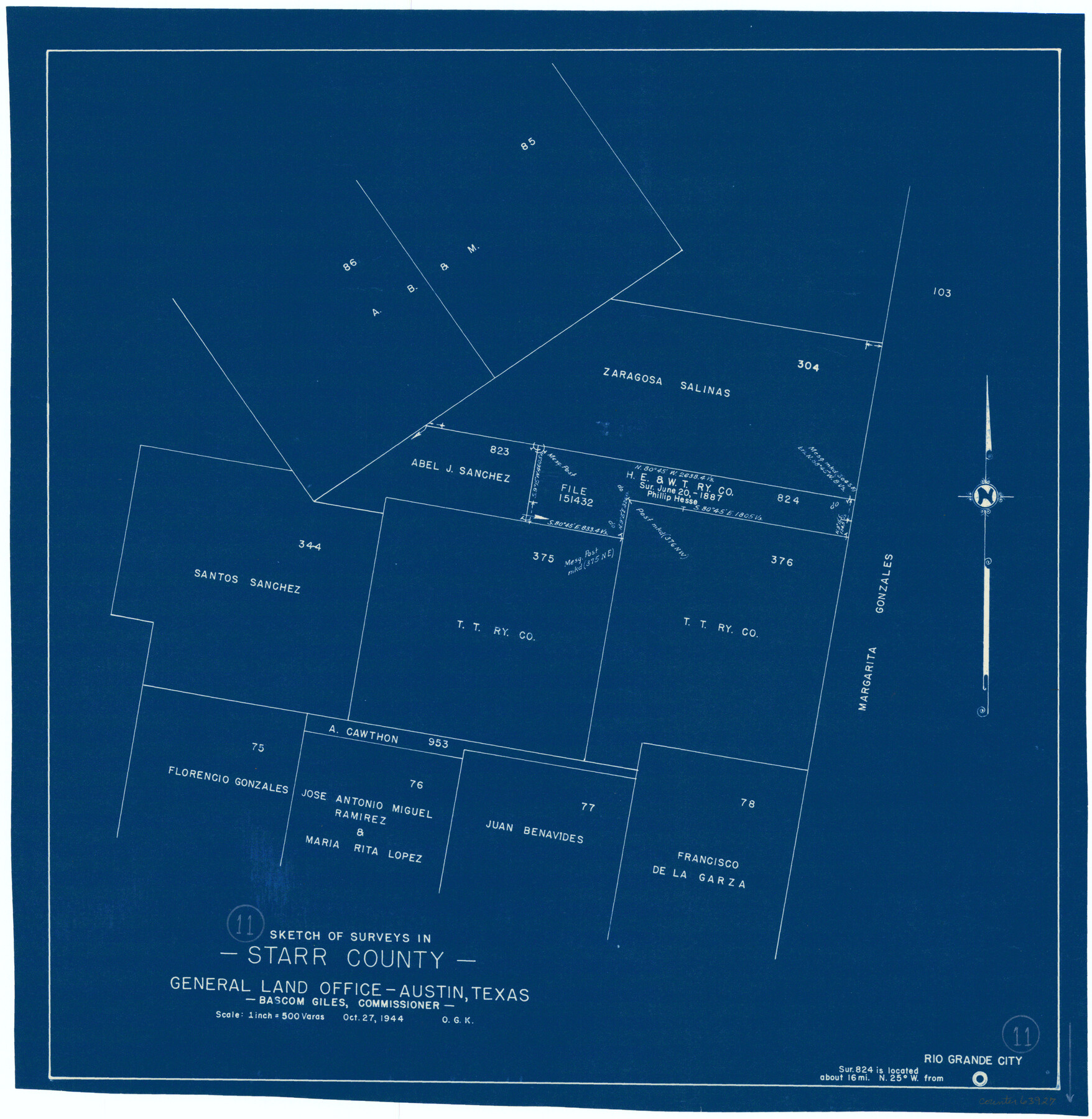
Starr County Working Sketch 11
-
Map/Doc
63927
-
Collection
General Map Collection
-
Object Dates
10/27/1944 (Creation Date)
-
People and Organizations
Otto G. Kurio (Draftsman)
-
Counties
Starr
-
Subjects
Surveying Working Sketch
-
Height x Width
18.1 x 17.7 inches
46.0 x 45.0 cm
-
Scale
1" = 500 varas
Part of: General Map Collection
The University of Texas at Austin

The University of Texas at Austin
Size 16.0 x 17.1 inches
Map/Doc 94388
Wise County Rolled Sketch 6

Print $20.00
- Digital $50.00
Wise County Rolled Sketch 6
2000
Size 32.0 x 43.1 inches
Map/Doc 8280
Texas-Indian Territory Denison Quadrangle

Print $20.00
- Digital $50.00
Texas-Indian Territory Denison Quadrangle
1901
Size 20.1 x 16.7 inches
Map/Doc 75110
Morris County Sketch File 1

Print $4.00
- Digital $50.00
Morris County Sketch File 1
Size 12.4 x 6.5 inches
Map/Doc 31963
San Patricio County Sketch File 49

Print $84.00
- Digital $50.00
San Patricio County Sketch File 49
1934
Size 9.1 x 11.4 inches
Map/Doc 36329
Gregg County Working Sketch 21

Print $20.00
- Digital $50.00
Gregg County Working Sketch 21
1966
Size 25.5 x 32.1 inches
Map/Doc 63288

Cherokee County Sketch File 33

Print $16.00
- Digital $50.00
Cherokee County Sketch File 33
1935
Size 11.5 x 7.2 inches
Map/Doc 18190
Kenedy County Rolled Sketch 11

Print $20.00
- Digital $50.00
Kenedy County Rolled Sketch 11
1938
Size 40.5 x 30.2 inches
Map/Doc 6471
Travis County State Real Property Sketch 15

Print $20.00
- Digital $50.00
Travis County State Real Property Sketch 15
1995
Size 29.6 x 29.5 inches
Map/Doc 61674
Burleson County Working Sketch 47

Print $20.00
- Digital $50.00
Burleson County Working Sketch 47
2010
Size 23.2 x 28.1 inches
Map/Doc 89620
Haskell County Sketch File 22

Print $6.00
- Digital $50.00
Haskell County Sketch File 22
Size 14.3 x 8.8 inches
Map/Doc 26179
You may also like
Culberson County Rolled Sketch 50

Print $20.00
- Digital $50.00
Culberson County Rolled Sketch 50
1963
Size 19.3 x 25.0 inches
Map/Doc 5669
Map of Harrison County

Print $20.00
- Digital $50.00
Map of Harrison County
1871
Size 18.2 x 19.3 inches
Map/Doc 4561
[Leagues 212- 217, 241- 244, and Vicinity]
![91430, [Leagues 212- 217, 241- 244, and Vicinity], Twichell Survey Records](https://historictexasmaps.com/wmedia_w700/maps/91430-1.tif.jpg)
Print $20.00
- Digital $50.00
[Leagues 212- 217, 241- 244, and Vicinity]
1902
Size 20.6 x 6.4 inches
Map/Doc 91430
[State Line - 103rd Meridian - in relation to Leagues]
![91551, [State Line - 103rd Meridian - in relation to Leagues], Twichell Survey Records](https://historictexasmaps.com/wmedia_w700/maps/91551-2.tif.jpg)
Print $20.00
- Digital $50.00
[State Line - 103rd Meridian - in relation to Leagues]
Size 19.9 x 8.3 inches
Map/Doc 91551
Newton County Working Sketch 23

Print $20.00
- Digital $50.00
Newton County Working Sketch 23
1952
Size 22.0 x 26.6 inches
Map/Doc 71269
Bexar County Sketch File 48

Print $4.00
- Digital $50.00
Bexar County Sketch File 48
Size 10.8 x 8.6 inches
Map/Doc 14528
Amistad International Reservoir on Rio Grande 66

Print $20.00
- Digital $50.00
Amistad International Reservoir on Rio Grande 66
1949
Size 28.5 x 39.6 inches
Map/Doc 73351
Dickens County

Print $20.00
- Digital $50.00
Dickens County
1915
Size 42.4 x 39.3 inches
Map/Doc 4722
La Salle County Working Sketch 29

Print $20.00
- Digital $50.00
La Salle County Working Sketch 29
1955
Size 25.8 x 27.4 inches
Map/Doc 70330
Brewster County Rolled Sketch 118

Print $20.00
- Digital $50.00
Brewster County Rolled Sketch 118
1971
Size 25.3 x 37.2 inches
Map/Doc 5295
Kinney County Rolled Sketch 16

Print $20.00
- Digital $50.00
Kinney County Rolled Sketch 16
1963
Size 36.4 x 43.8 inches
Map/Doc 9356
Tyler County Working Sketch 9

Print $20.00
- Digital $50.00
Tyler County Working Sketch 9
1937
Size 25.7 x 27.1 inches
Map/Doc 69479