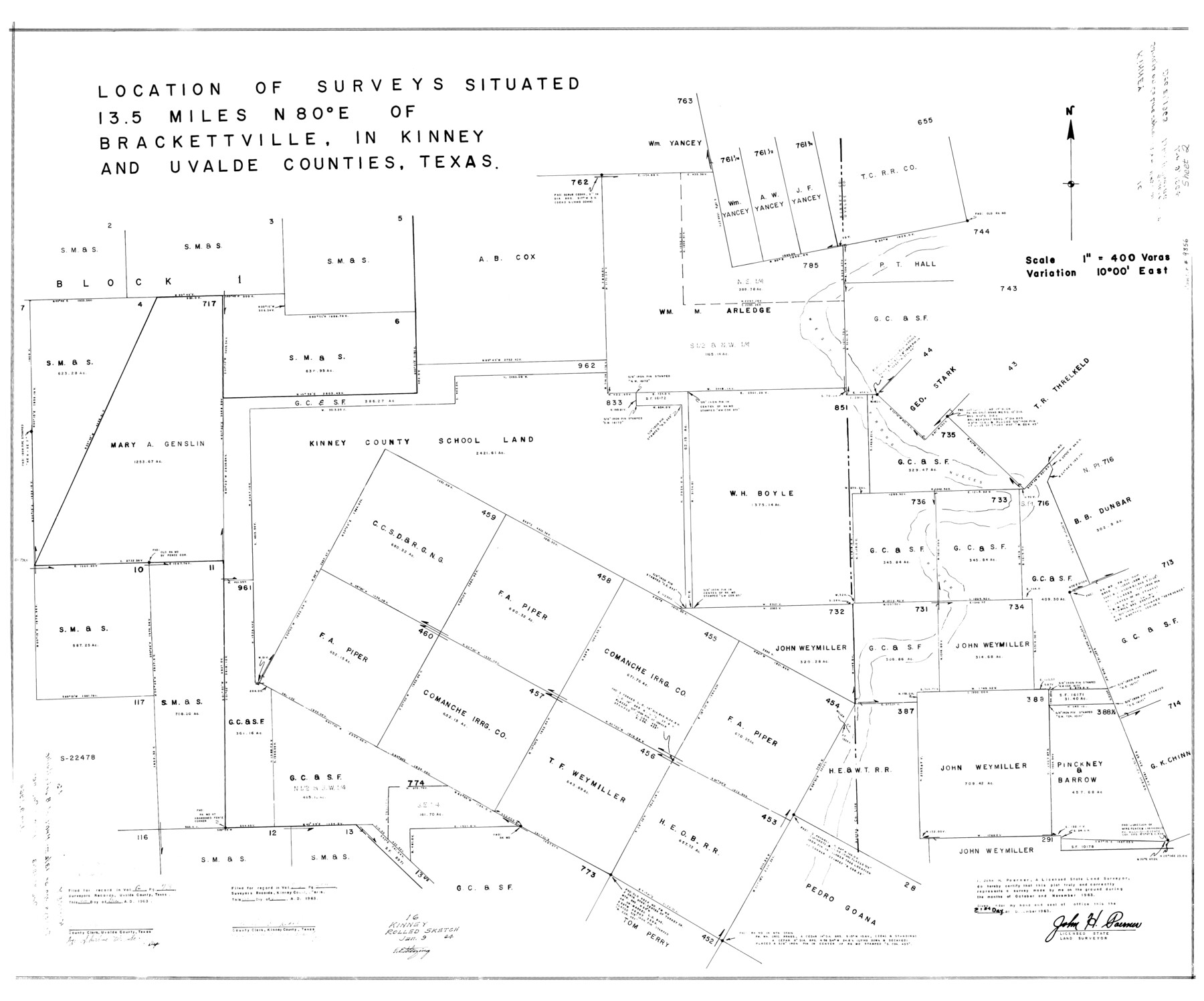
Kinney County Rolled Sketch 16
Location of surveys situated in Kinney and Uvalde Counties, east of Brackettville
-
Map/Doc
9356
-
Collection
General Map Collection
-
Object Dates
1963/12/21 (Creation Date)
1964/1/9 (File Date)
-
People and Organizations
John H. Poerner (Surveyor/Engineer)
-
Counties
Kinney Uvalde
-
Subjects
Surveying Rolled Sketch
-
Height x Width
36.4 x 43.8 inches
92.5 x 111.3 cm
-
Scale
1" = 400 varas
Part of: General Map Collection
Dawson County Sketch File 26

Print $10.00
- Digital $50.00
Dawson County Sketch File 26
Size 14.7 x 9.1 inches
Map/Doc 20583
Nueces County NRC Article 33.136 Sketch 10

Print $36.00
- Digital $50.00
Nueces County NRC Article 33.136 Sketch 10
2004
Size 23.9 x 35.9 inches
Map/Doc 83526
Travis County Working Sketch 27

Print $20.00
- Digital $50.00
Travis County Working Sketch 27
1951
Size 17.6 x 31.6 inches
Map/Doc 69411
Smith County Working Sketch 8

Print $20.00
- Digital $50.00
Smith County Working Sketch 8
1941
Size 28.9 x 22.7 inches
Map/Doc 63893
Garza County Sketch File 3

Print $20.00
- Digital $50.00
Garza County Sketch File 3
1879
Size 18.6 x 17.6 inches
Map/Doc 11544
Sutton County Working Sketch 50

Print $20.00
- Digital $50.00
Sutton County Working Sketch 50
1955
Size 27.4 x 22.2 inches
Map/Doc 62393
Nueces County NRC Article 33.136 Sketch 11

Print $20.00
- Digital $50.00
Nueces County NRC Article 33.136 Sketch 11
2000
Size 25.8 x 43.0 inches
Map/Doc 84334
Location Through GC&SFRRCo., Runnels County, Texas

Print $20.00
- Digital $50.00
Location Through GC&SFRRCo., Runnels County, Texas
1898
Size 21.5 x 32.8 inches
Map/Doc 64509
El Paso County Boundary File 10

Print $14.00
- Digital $50.00
El Paso County Boundary File 10
Size 12.7 x 8.2 inches
Map/Doc 53118
Midland County Working Sketch 10

Print $20.00
- Digital $50.00
Midland County Working Sketch 10
1951
Size 30.2 x 21.2 inches
Map/Doc 70990
Duval County Boundary File 3g

Print $4.00
- Digital $50.00
Duval County Boundary File 3g
Size 9.9 x 7.8 inches
Map/Doc 52747
Il Cuscho Citta Principale Della Provincia del Peru

Print $20.00
- Digital $50.00
Il Cuscho Citta Principale Della Provincia del Peru
1592
Size 12.3 x 15.4 inches
Map/Doc 97026
You may also like
The Republic County of Shelby. January 28, 1839

Print $20.00
The Republic County of Shelby. January 28, 1839
2020
Size 21.1 x 21.7 inches
Map/Doc 96281
The Republic County of Harris. May 15, 1838

Print $20.00
The Republic County of Harris. May 15, 1838
2020
Size 17.7 x 21.7 inches
Map/Doc 96163
Marion County Working Sketch 15

Print $20.00
- Digital $50.00
Marion County Working Sketch 15
1954
Size 37.3 x 28.8 inches
Map/Doc 70791
Steele Addition, Seagraves, Texas

Print $20.00
- Digital $50.00
Steele Addition, Seagraves, Texas
Size 17.4 x 26.3 inches
Map/Doc 92655
[Blocks CD, OP and GH in Crockett, Schleicher & Sutton Counties, Texas]
![75776, [Blocks CD, OP and GH in Crockett, Schleicher & Sutton Counties, Texas], Maddox Collection](https://historictexasmaps.com/wmedia_w700/maps/75776.tif.jpg)
Print $20.00
- Digital $50.00
[Blocks CD, OP and GH in Crockett, Schleicher & Sutton Counties, Texas]
Size 22.5 x 27.5 inches
Map/Doc 75776
Flight Mission No. CLL-1N, Frame 33, Willacy County

Print $20.00
- Digital $50.00
Flight Mission No. CLL-1N, Frame 33, Willacy County
1954
Size 18.4 x 22.1 inches
Map/Doc 87014
Flight Mission No. DCL-7C, Frame 37, Kenedy County

Print $20.00
- Digital $50.00
Flight Mission No. DCL-7C, Frame 37, Kenedy County
1943
Size 15.4 x 15.3 inches
Map/Doc 86025
Close-up: USA - Arkansas, Oklahoma, Louisiana, Texas

Close-up: USA - Arkansas, Oklahoma, Louisiana, Texas
1974
Size 35.1 x 23.1 inches
Map/Doc 96845
[Sections 1035-1038, E. B. Logan survey and vicinity]
![90342, [Sections 1035-1038, E. B. Logan survey and vicinity], Twichell Survey Records](https://historictexasmaps.com/wmedia_w700/maps/90342-1.tif.jpg)
Print $3.00
- Digital $50.00
[Sections 1035-1038, E. B. Logan survey and vicinity]
Size 15.0 x 10.6 inches
Map/Doc 90342
Flight Mission No. DQO-1K, Frame 38, Galveston County

Print $20.00
- Digital $50.00
Flight Mission No. DQO-1K, Frame 38, Galveston County
1952
Size 18.0 x 17.6 inches
Map/Doc 84981
Part of the boundary between the United States and Texas: from Sabine River northward to the 36th mile mound (A.2)

Print $2.00
- Digital $50.00
Part of the boundary between the United States and Texas: from Sabine River northward to the 36th mile mound (A.2)
1842
Size 12.5 x 7.3 inches
Map/Doc 65387
Zapata County Sketch File 3

Print $6.00
- Digital $50.00
Zapata County Sketch File 3
1883
Size 16.3 x 10.7 inches
Map/Doc 40904