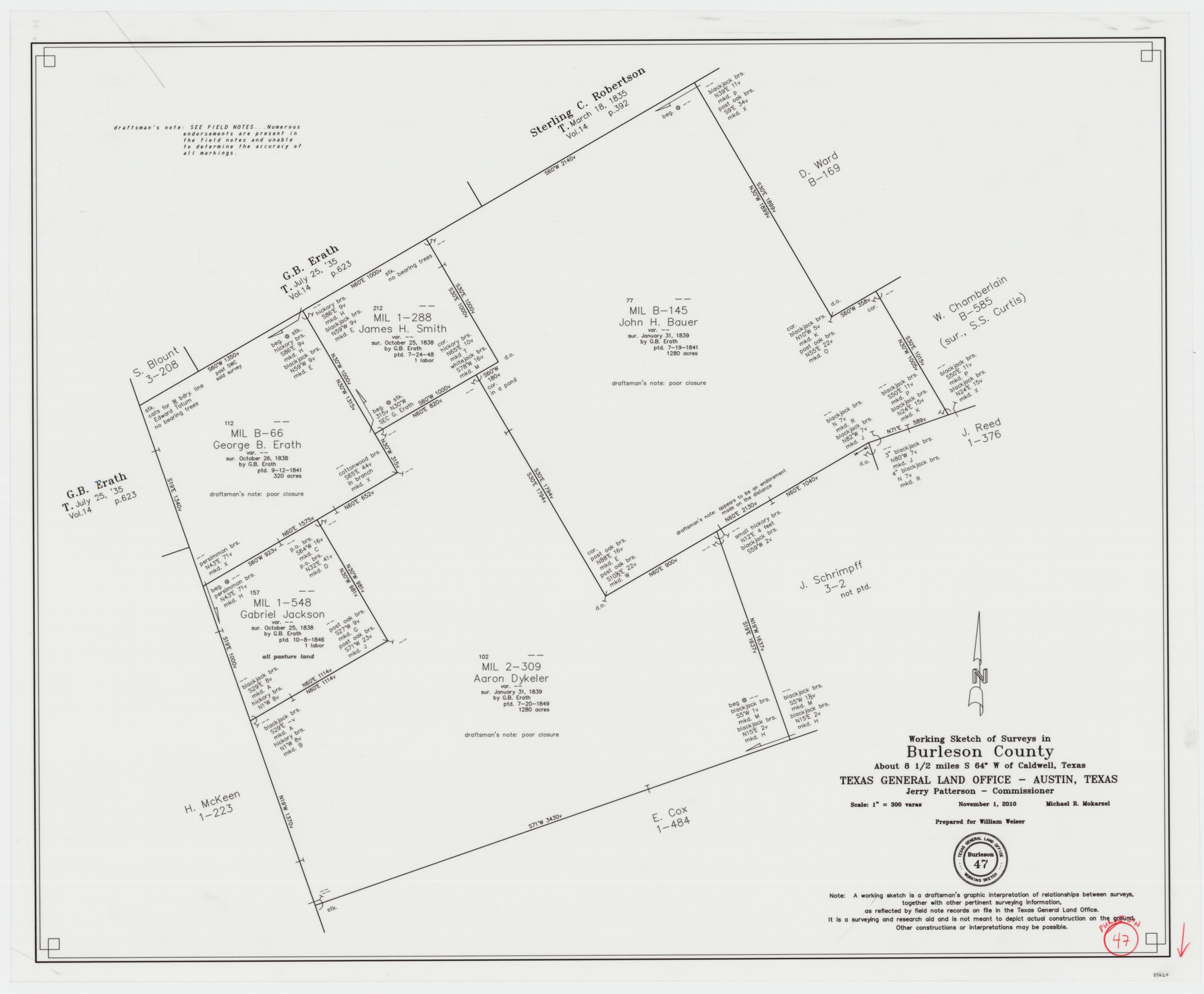
Burleson County Working Sketch 47
-
Map/Doc
89620
-
Collection
General Map Collection
-
Object Dates
2010/11/1 (Creation Date)
-
People and Organizations
Michael R. Mokarzel (Draftsman)
-
Counties
Burleson
-
Subjects
Surveying Working Sketch
-
Height x Width
23.2 x 28.1 inches
58.9 x 71.4 cm
-
Scale
1" = 300 varas
Part of: General Map Collection
Brazoria County Sketch File 28a

Print $40.00
- Digital $50.00
Brazoria County Sketch File 28a
1913
Size 21.0 x 15.2 inches
Map/Doc 10954
Right of Way & Track Map, San Antonio & Aransas Pass Railway Co.

Print $40.00
- Digital $50.00
Right of Way & Track Map, San Antonio & Aransas Pass Railway Co.
1919
Size 25.3 x 56.6 inches
Map/Doc 64214
Flight Mission No. DAG-21K, Frame 127, Matagorda County

Print $20.00
- Digital $50.00
Flight Mission No. DAG-21K, Frame 127, Matagorda County
1952
Size 18.5 x 22.4 inches
Map/Doc 86453
Kimble County Working Sketch 47

Print $20.00
- Digital $50.00
Kimble County Working Sketch 47
1951
Size 42.9 x 24.3 inches
Map/Doc 70115
Presidio County Working Sketch 140

Print $20.00
- Digital $50.00
Presidio County Working Sketch 140
1990
Size 29.8 x 39.9 inches
Map/Doc 71818
Travis County Sketch File 61

Print $8.00
- Digital $50.00
Travis County Sketch File 61
1948
Size 14.4 x 8.8 inches
Map/Doc 38427
Map of Brown County

Print $20.00
- Digital $50.00
Map of Brown County
1876
Size 25.9 x 23.3 inches
Map/Doc 3341
Atascosa County Sketch File 21

Print $40.00
- Digital $50.00
Atascosa County Sketch File 21
Size 20.0 x 19.8 inches
Map/Doc 10859
Andrews County

Print $40.00
- Digital $50.00
Andrews County
1951
Size 42.7 x 54.5 inches
Map/Doc 1769
Briscoe County Working Sketch 12

Print $40.00
- Digital $50.00
Briscoe County Working Sketch 12
1984
Size 43.6 x 60.3 inches
Map/Doc 67815
Limestone County Working Sketch 26

Print $20.00
- Digital $50.00
Limestone County Working Sketch 26
1982
Size 39.6 x 44.1 inches
Map/Doc 70576
Hemphill County Working Sketch 25

Print $40.00
- Digital $50.00
Hemphill County Working Sketch 25
1974
Size 44.0 x 60.7 inches
Map/Doc 66120
You may also like
Fayette County Working Sketch 10

Print $20.00
- Digital $50.00
Fayette County Working Sketch 10
1985
Size 27.1 x 38.5 inches
Map/Doc 69174
Flight Mission No. CRC-5R, Frame 23, Chambers County

Print $20.00
- Digital $50.00
Flight Mission No. CRC-5R, Frame 23, Chambers County
1956
Size 18.8 x 22.4 inches
Map/Doc 84945
Menard County Rolled Sketch 15

Print $20.00
- Digital $50.00
Menard County Rolled Sketch 15
1983
Size 27.9 x 22.0 inches
Map/Doc 6761
Young County Boundary File 98a

Print $32.00
- Digital $50.00
Young County Boundary File 98a
Size 10.2 x 8.0 inches
Map/Doc 60211
Dallas County Working Sketch 4

Print $20.00
- Digital $50.00
Dallas County Working Sketch 4
1935
Size 24.1 x 30.4 inches
Map/Doc 68570
[Sketch showing H. & G. N. Blk. 1]
![89634, [Sketch showing H. & G. N. Blk. 1], Twichell Survey Records](https://historictexasmaps.com/wmedia_w700/maps/89634-1.tif.jpg)
Print $40.00
- Digital $50.00
[Sketch showing H. & G. N. Blk. 1]
Size 27.1 x 60.6 inches
Map/Doc 89634
Terrell County Working Sketch 40

Print $20.00
- Digital $50.00
Terrell County Working Sketch 40
1956
Size 22.9 x 29.1 inches
Map/Doc 62133
Map of Coryell County

Print $20.00
- Digital $50.00
Map of Coryell County
1863
Size 23.1 x 27.4 inches
Map/Doc 3443
Montgomery County Rolled Sketch 18

Print $40.00
- Digital $50.00
Montgomery County Rolled Sketch 18
Size 51.4 x 25.3 inches
Map/Doc 9528
Township No. 5 South Range No. 10 West of the Indian Meridian

Print $20.00
- Digital $50.00
Township No. 5 South Range No. 10 West of the Indian Meridian
1874
Size 19.2 x 24.5 inches
Map/Doc 75161
Archer County Sketch File 22

Print $12.00
- Digital $50.00
Archer County Sketch File 22
1936
Size 11.1 x 8.6 inches
Map/Doc 13658
Pecos County Working Sketch 105

Print $40.00
- Digital $50.00
Pecos County Working Sketch 105
1971
Size 49.3 x 43.5 inches
Map/Doc 71578