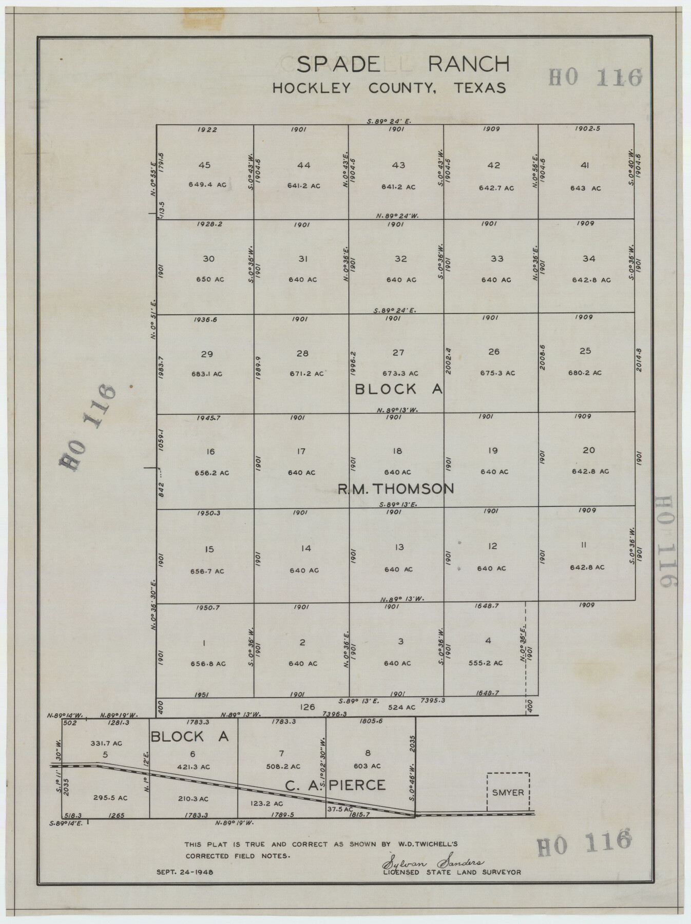
Spade Ranch Hockley County, Texas
HO116
-
Map/Doc
92225
-
Collection
Twichell Survey Records
-
Object Dates
9/24/1948 (Creation Date)
-
People and Organizations
Sylvan Sanders (Surveyor/Engineer)
-
Counties
Hockley
-
Height x Width
14.2 x 19.0 inches
36.1 x 48.3 cm
Part of: Twichell Survey Records
[Parts of PSL Blocks B18, B19, B28, B20 and B29]
![91952, [Parts of PSL Blocks B18, B19, B28, B20 and B29], Twichell Survey Records](https://historictexasmaps.com/wmedia_w700/maps/91952-1.tif.jpg)
Print $20.00
- Digital $50.00
[Parts of PSL Blocks B18, B19, B28, B20 and B29]
Size 21.4 x 28.0 inches
Map/Doc 91952
Dawson County Sketch [showing T. & P. Blocks 34 and 33, Township 5 N]
![90546, Dawson County Sketch [showing T. & P. Blocks 34 and 33, Township 5 N], Twichell Survey Records](https://historictexasmaps.com/wmedia_w700/maps/90546-1.tif.jpg)
Print $2.00
- Digital $50.00
Dawson County Sketch [showing T. & P. Blocks 34 and 33, Township 5 N]
Size 12.6 x 7.0 inches
Map/Doc 90546
[Mrs. Adair Resurvey]
![89976, [Mrs. Adair Resurvey], Twichell Survey Records](https://historictexasmaps.com/wmedia_w700/maps/89976-1.tif.jpg)
Print $20.00
- Digital $50.00
[Mrs. Adair Resurvey]
1918
Size 36.5 x 27.4 inches
Map/Doc 89976
[H. & G. N. RR. Co. Block 1]
![90892, [H. & G. N. RR. Co. Block 1], Twichell Survey Records](https://historictexasmaps.com/wmedia_w700/maps/90892-1.tif.jpg)
Print $20.00
- Digital $50.00
[H. & G. N. RR. Co. Block 1]
1902
Size 14.9 x 15.8 inches
Map/Doc 90892
Correct Map Lamb County (skeleton sketch)

Print $40.00
- Digital $50.00
Correct Map Lamb County (skeleton sketch)
Size 56.2 x 79.4 inches
Map/Doc 93139
Working Sketch in Bastrop County

Print $20.00
- Digital $50.00
Working Sketch in Bastrop County
1921
Size 14.3 x 15.6 inches
Map/Doc 90233
Subdivision of School Land League 12

Print $2.00
- Digital $50.00
Subdivision of School Land League 12
Size 8.7 x 11.2 inches
Map/Doc 90988
[Sketch of area around Geo. C. Kimball, M. G. Dickes, and S. F. Sanders surveys]
![92021, [Sketch of area around Geo. C. Kimball, M. G. Dickes, and S. F. Sanders surveys], Twichell Survey Records](https://historictexasmaps.com/wmedia_w700/maps/92021-1.tif.jpg)
Print $20.00
- Digital $50.00
[Sketch of area around Geo. C. Kimball, M. G. Dickes, and S. F. Sanders surveys]
Size 27.0 x 26.3 inches
Map/Doc 92021
Boyd-Gordon Addition to Idalou, a Subdivision of a Part Tracts 27, 28, 29 and 30 of the Ross Addition to Idalou

Print $3.00
- Digital $50.00
Boyd-Gordon Addition to Idalou, a Subdivision of a Part Tracts 27, 28, 29 and 30 of the Ross Addition to Idalou
1953
Size 11.8 x 17.8 inches
Map/Doc 92873
[Sketch N, showing Blocks 5-7, 13, 48-51, and C1-7]
![91771, [Sketch N, showing Blocks 5-7, 13, 48-51, and C1-7], Twichell Survey Records](https://historictexasmaps.com/wmedia_w700/maps/91771-1.tif.jpg)
Print $20.00
- Digital $50.00
[Sketch N, showing Blocks 5-7, 13, 48-51, and C1-7]
Size 32.1 x 25.9 inches
Map/Doc 91771

[Capitol Leagues 225-238]
![90677, [Capitol Leagues 225-238], Twichell Survey Records](https://historictexasmaps.com/wmedia_w700/maps/90677-1.tif.jpg)
Print $20.00
- Digital $50.00
[Capitol Leagues 225-238]
Size 23.2 x 13.0 inches
Map/Doc 90677
You may also like
Flight Mission No. CGN-3P, Frame 24, San Patricio County

Print $20.00
- Digital $50.00
Flight Mission No. CGN-3P, Frame 24, San Patricio County
1956
Size 18.5 x 22.3 inches
Map/Doc 86982
Real County Working Sketch 38

Print $20.00
- Digital $50.00
Real County Working Sketch 38
1951
Size 34.0 x 37.9 inches
Map/Doc 71930
Flight Mission No. CRC-4R, Frame 76, Chambers County

Print $20.00
- Digital $50.00
Flight Mission No. CRC-4R, Frame 76, Chambers County
1956
Size 18.8 x 22.4 inches
Map/Doc 84880
Map of Hamilton County

Print $20.00
- Digital $50.00
Map of Hamilton County
1872
Size 15.1 x 22.1 inches
Map/Doc 4555
Jackson County Sketch File 6a

Print $30.00
- Digital $50.00
Jackson County Sketch File 6a
1894
Size 13.6 x 8.8 inches
Map/Doc 27634
Gradient Boundary Survey of Canadian River through portions of Hutchinson & Roberts Counties, Texas

Print $40.00
- Digital $50.00
Gradient Boundary Survey of Canadian River through portions of Hutchinson & Roberts Counties, Texas
1989
Size 39.6 x 139.0 inches
Map/Doc 3120
Dawson County Working Sketch 22

Print $20.00
- Digital $50.00
Dawson County Working Sketch 22
1989
Size 26.2 x 20.5 inches
Map/Doc 68566
Bandera County Working Sketch 22

Print $20.00
- Digital $50.00
Bandera County Working Sketch 22
1949
Size 42.8 x 24.9 inches
Map/Doc 67618
Cherokee County Rolled Sketch 2

Print $20.00
- Digital $50.00
Cherokee County Rolled Sketch 2
1954
Size 44.6 x 36.0 inches
Map/Doc 8596
Floyd County Sketch File 32

Print $8.00
- Digital $50.00
Floyd County Sketch File 32
1952
Size 14.3 x 8.9 inches
Map/Doc 22792
Brown County Sketch File 20

Print $10.00
- Digital $50.00
Brown County Sketch File 20
Size 6.6 x 8.3 inches
Map/Doc 16620
Ulyss Dalmont Ranch situated in Gaines Co., Texas, 21316 Acres

Print $20.00
- Digital $50.00
Ulyss Dalmont Ranch situated in Gaines Co., Texas, 21316 Acres
Size 17.6 x 21.8 inches
Map/Doc 90915