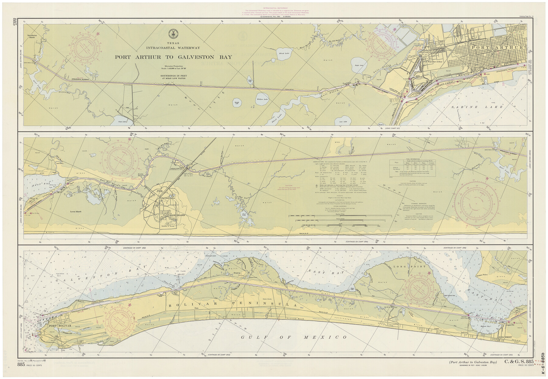
Intracoastal Waterway - Port Arthur to Galveston Bay
K-6-885a
-
Map/Doc
69832
-
Collection
General Map Collection
-
Object Dates
1960/9/12 (Creation Date)
-
Counties
Jefferson Chambers Galveston
-
Subjects
Nautical Charts
-
Height x Width
26.7 x 38.8 inches
67.8 x 98.6 cm
Part of: General Map Collection
Flight Mission No. BRE-2P, Frame 36, Nueces County

Print $20.00
- Digital $50.00
Flight Mission No. BRE-2P, Frame 36, Nueces County
1956
Size 18.5 x 22.7 inches
Map/Doc 86738
St. Louis, Brownsville & Mexico Railway Location Map from Mile 100 to Mile 120

Print $40.00
- Digital $50.00
St. Louis, Brownsville & Mexico Railway Location Map from Mile 100 to Mile 120
1905
Size 19.4 x 67.8 inches
Map/Doc 64168
Randall County Rolled Sketch 6

Print $20.00
- Digital $50.00
Randall County Rolled Sketch 6
Size 25.0 x 23.9 inches
Map/Doc 7426

Uvalde County Rolled Sketch 24

Print $20.00
- Digital $50.00
Uvalde County Rolled Sketch 24
2014
Size 16.2 x 16.1 inches
Map/Doc 93722
Brewster County Rolled Sketch 90

Print $20.00
- Digital $50.00
Brewster County Rolled Sketch 90
1949
Size 37.5 x 31.1 inches
Map/Doc 8506
Blanco County Rolled Sketch 13

Print $20.00
- Digital $50.00
Blanco County Rolled Sketch 13
Size 14.2 x 28.9 inches
Map/Doc 5149
Webb County Working Sketch 87

Print $20.00
- Digital $50.00
Webb County Working Sketch 87
1981
Size 46.3 x 39.6 inches
Map/Doc 72454

Kleberg County Rolled Sketch 10-16

Print $20.00
- Digital $50.00
Kleberg County Rolled Sketch 10-16
1952
Size 37.0 x 33.2 inches
Map/Doc 9381
Shelby County Working Sketch 24

Print $20.00
- Digital $50.00
Shelby County Working Sketch 24
1985
Size 38.3 x 39.0 inches
Map/Doc 63878
Flight Mission No. DCL-6C, Frame 97, Kenedy County

Print $20.00
- Digital $50.00
Flight Mission No. DCL-6C, Frame 97, Kenedy County
1943
Size 18.6 x 22.3 inches
Map/Doc 85927
You may also like
King County Working Sketch 15

Print $40.00
- Digital $50.00
King County Working Sketch 15
1979
Size 41.6 x 60.4 inches
Map/Doc 70179
Cooke County Boundary File 2a

Print $8.00
- Digital $50.00
Cooke County Boundary File 2a
Size 12.2 x 7.7 inches
Map/Doc 51849
Tom Green County Boundary File 87a

Print $6.00
- Digital $50.00
Tom Green County Boundary File 87a
Size 13.1 x 8.6 inches
Map/Doc 59398
Crockett County Sketch File 64

Print $20.00
- Digital $50.00
Crockett County Sketch File 64
1927
Size 17.0 x 21.3 inches
Map/Doc 11229
Lynn County Sketch File 18

Print $4.00
- Digital $50.00
Lynn County Sketch File 18
1940
Size 11.2 x 8.8 inches
Map/Doc 30514
Orange County Sketch File 11a

Print $4.00
- Digital $50.00
Orange County Sketch File 11a
1884
Size 6.1 x 6.1 inches
Map/Doc 33322
Montgomery County

Print $20.00
- Digital $50.00
Montgomery County
1861
Size 18.4 x 22.3 inches
Map/Doc 3890
[Sketch of Leagues 458, 459, 474, 475, 480 and 481]
![91547, [Sketch of Leagues 458, 459, 474, 475, 480 and 481], Twichell Survey Records](https://historictexasmaps.com/wmedia_w700/maps/91547-1.tif.jpg)
Print $2.00
- Digital $50.00
[Sketch of Leagues 458, 459, 474, 475, 480 and 481]
Size 5.2 x 8.3 inches
Map/Doc 91547
The Republic County of Lamar. January 28, 1841

Print $20.00
The Republic County of Lamar. January 28, 1841
2020
Size 16.4 x 21.7 inches
Map/Doc 96203
Pecos County Rolled Sketch 25B

Print $20.00
- Digital $50.00
Pecos County Rolled Sketch 25B
1892
Size 22.2 x 16.0 inches
Map/Doc 7210
Flight Mission No. DAG-21K, Frame 107, Matagorda County

Print $20.00
- Digital $50.00
Flight Mission No. DAG-21K, Frame 107, Matagorda County
1952
Size 18.6 x 22.4 inches
Map/Doc 86435
United States of North America (Eastern and Central)

Print $20.00
- Digital $50.00
United States of North America (Eastern and Central)
1862
Size 19.3 x 26.2 inches
Map/Doc 93667