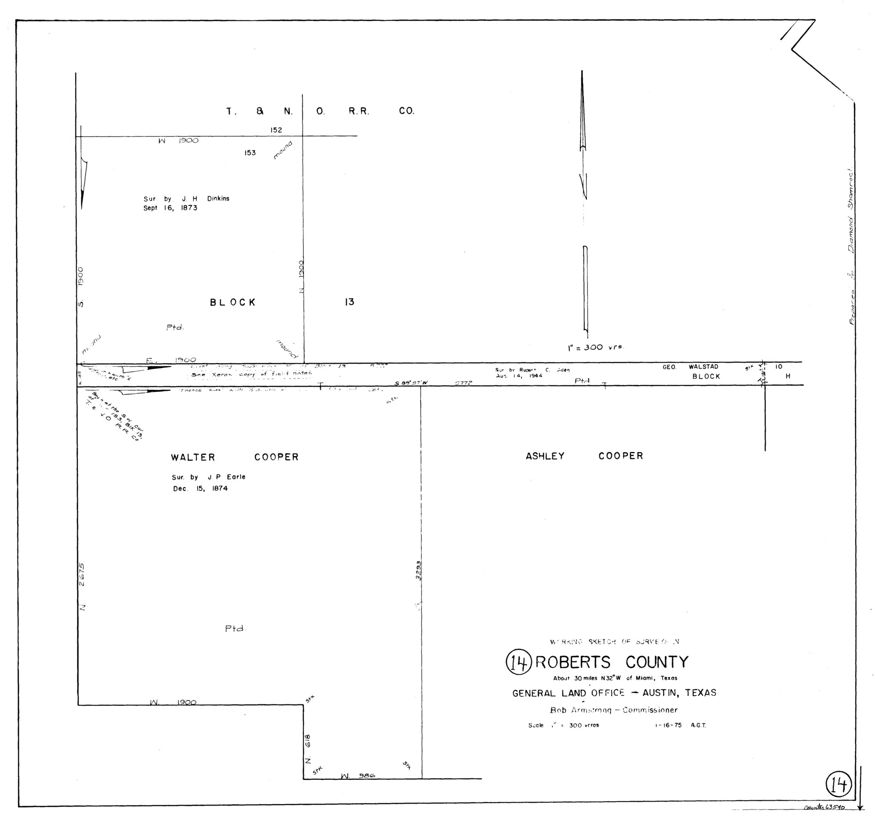
Roberts County Working Sketch 14
-
Map/Doc
63540
-
Collection
General Map Collection
-
Object Dates
1/16/1975 (Creation Date)
-
People and Organizations
Abner G. Trigg (Draftsman)
-
Counties
Roberts
-
Subjects
Surveying Working Sketch
-
Height x Width
23.1 x 24.6 inches
58.7 x 62.5 cm
-
Scale
1" = 300 varas
Part of: General Map Collection
Brewster County Sketch File NS-4e

Print $26.00
- Digital $50.00
Brewster County Sketch File NS-4e
1930
Size 8.7 x 11.2 inches
Map/Doc 15965
Reeves County Working Sketch 13

Print $20.00
- Digital $50.00
Reeves County Working Sketch 13
1959
Size 30.5 x 33.4 inches
Map/Doc 63456
Map of Lee County

Print $20.00
- Digital $50.00
Map of Lee County
1874
Size 22.4 x 18.6 inches
Map/Doc 3805
Hardin County Working Sketch 25

Print $20.00
- Digital $50.00
Hardin County Working Sketch 25
1950
Size 10.8 x 20.1 inches
Map/Doc 63423
Flight Mission No. BRA-16M, Frame 147, Jefferson County

Print $20.00
- Digital $50.00
Flight Mission No. BRA-16M, Frame 147, Jefferson County
1953
Size 18.6 x 22.3 inches
Map/Doc 85753
Intracoastal Waterway - Port Arthur to Galveston Bay

Print $20.00
- Digital $50.00
Intracoastal Waterway - Port Arthur to Galveston Bay
1957
Size 27.0 x 38.6 inches
Map/Doc 69830
Sterling County Rolled Sketch 37

Print $20.00
- Digital $50.00
Sterling County Rolled Sketch 37
Size 25.4 x 31.8 inches
Map/Doc 7861
Duval County Rolled Sketch HD

Print $20.00
- Digital $50.00
Duval County Rolled Sketch HD
1939
Size 22.8 x 32.8 inches
Map/Doc 5767
Travis County Sketch File 55

Print $20.00
- Digital $50.00
Travis County Sketch File 55
1945
Size 27.3 x 14.5 inches
Map/Doc 12471
Map of Shelby County

Print $20.00
- Digital $50.00
Map of Shelby County
1839
Size 24.5 x 25.7 inches
Map/Doc 4032
Concho County Working Sketch 8

Print $20.00
- Digital $50.00
Concho County Working Sketch 8
1948
Size 47.0 x 42.6 inches
Map/Doc 68190
Jefferson County Working Sketch 3

Print $20.00
- Digital $50.00
Jefferson County Working Sketch 3
1904
Size 25.1 x 21.2 inches
Map/Doc 66546
You may also like
Map of Titus County

Print $20.00
- Digital $50.00
Map of Titus County
1879
Size 23.3 x 14.7 inches
Map/Doc 4082
Donley County Boundary File 6

Print $6.00
- Digital $50.00
Donley County Boundary File 6
Size 5.7 x 8.7 inches
Map/Doc 52637
[Sketch showing Northwest corner of Fisher County, Northeast corner of Scurry County and South part of Kent County]
![90917, [Sketch showing Northwest corner of Fisher County, Northeast corner of Scurry County and South part of Kent County], Twichell Survey Records](https://historictexasmaps.com/wmedia_w700/maps/90917-1.tif.jpg)
Print $20.00
- Digital $50.00
[Sketch showing Northwest corner of Fisher County, Northeast corner of Scurry County and South part of Kent County]
1900
Size 17.7 x 15.0 inches
Map/Doc 90917

Foard County Sketch File 18

Print $6.00
- Digital $50.00
Foard County Sketch File 18
1888
Size 13.0 x 8.5 inches
Map/Doc 22834
Panola County Working Sketch Graphic Index

Print $20.00
- Digital $50.00
Panola County Working Sketch Graphic Index
1947
Map/Doc 76660
Cochran County Sketch File 8

Print $32.00
- Digital $50.00
Cochran County Sketch File 8
1940
Size 11.0 x 8.8 inches
Map/Doc 18555
Working Sketch in Baylor and Throckmorton Cos.

Print $20.00
- Digital $50.00
Working Sketch in Baylor and Throckmorton Cos.
1890
Size 24.2 x 20.8 inches
Map/Doc 75771
The Republic County of Refugio. December 2, 1841

Print $20.00
The Republic County of Refugio. December 2, 1841
2020
Size 22.3 x 21.6 inches
Map/Doc 96257
Liberty County Sketch File 2

Print $2.00
- Digital $50.00
Liberty County Sketch File 2
Size 7.7 x 3.3 inches
Map/Doc 29883
Jackson County

Print $20.00
- Digital $50.00
Jackson County
1920
Size 45.9 x 39.1 inches
Map/Doc 73191
Sutton County Working Sketch 58

Print $40.00
- Digital $50.00
Sutton County Working Sketch 58
1958
Size 57.3 x 37.5 inches
Map/Doc 62401