Jackson County Rolled Sketch 3C
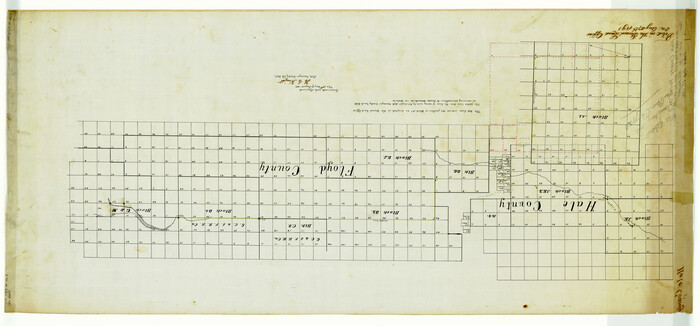
[Correspondence and sketch of some surveys in Jackson County]
-
Map/Doc
6339
-
Collection
General Map Collection
-
Object Dates
1913/7/25 (Creation Date)
1914/4/22 (File Date)
-
People and Organizations
Wm. H. Leckie (Surveyor/Engineer)
Robt. J. Bryan (Surveyor/Engineer)
-
Counties
Jackson
-
Subjects
Surveying Rolled Sketch
-
Height x Width
23.7 x 21.8 inches
60.2 x 55.4 cm
-
Medium
multi-page, multi-format
Related maps
Jackson County Sketch File 16

Print $10.00
- Digital $50.00
Jackson County Sketch File 16
1913
Size 14.3 x 8.7 inches
Map/Doc 27668
Part of: General Map Collection
Presidio County Rolled Sketch 81

Print $20.00
- Digital $50.00
Presidio County Rolled Sketch 81
Size 19.2 x 36.8 inches
Map/Doc 7368
Nacogdoches County Sketch File 10

Print $6.00
- Digital $50.00
Nacogdoches County Sketch File 10
1886
Size 12.9 x 11.0 inches
Map/Doc 32253
Brazoria County Rolled Sketch 25

Print $40.00
- Digital $50.00
Brazoria County Rolled Sketch 25
1935
Size 50.8 x 33.5 inches
Map/Doc 8928
Matagorda Bay and Approaches

Print $20.00
- Digital $50.00
Matagorda Bay and Approaches
1961
Size 35.0 x 45.0 inches
Map/Doc 73382
South Part of Webb County

Print $40.00
- Digital $50.00
South Part of Webb County
1984
Size 41.2 x 61.5 inches
Map/Doc 77453
Map of Brewster Co.

Print $40.00
- Digital $50.00
Map of Brewster Co.
1896
Size 58.4 x 17.3 inches
Map/Doc 4892
Wilbarger County Sketch File 8

Print $4.00
- Digital $50.00
Wilbarger County Sketch File 8
1885
Size 14.2 x 8.6 inches
Map/Doc 40179
Sutton County Sketch File 43

Print $20.00
- Digital $50.00
Sutton County Sketch File 43
Size 29.1 x 12.4 inches
Map/Doc 12391
Kinney County Sketch File B

Print $8.00
- Digital $50.00
Kinney County Sketch File B
1873
Size 11.9 x 8.1 inches
Map/Doc 29119
Kimble County Working Sketch 53

Print $20.00
- Digital $50.00
Kimble County Working Sketch 53
1953
Size 24.5 x 35.9 inches
Map/Doc 70121
Reeves County

Print $40.00
- Digital $50.00
Reeves County
1945
Size 48.3 x 39.8 inches
Map/Doc 73273
Gonzales County Working Sketch 4a

Print $20.00
- Digital $50.00
Gonzales County Working Sketch 4a
1979
Size 30.9 x 32.2 inches
Map/Doc 63219
You may also like
[I. Killough and Hiram Cates surveys and vicinity]
![91845, [I. Killough and Hiram Cates surveys and vicinity], Twichell Survey Records](https://historictexasmaps.com/wmedia_w700/maps/91845-1.tif.jpg)
Print $3.00
- Digital $50.00
[I. Killough and Hiram Cates surveys and vicinity]
Size 16.9 x 10.5 inches
Map/Doc 91845
The Star of Llano County

Price $20.00
The Star of Llano County
2023
Size 3.3 x 2.8 inches
Map/Doc 97175
Hale County Rolled Sketch 3
Print $40.00
- Digital $50.00
Hale County Rolled Sketch 3
1891
Size 51.7 x 24.1 inches
Map/Doc 9093
Flight Mission No. DQN-7K, Frame 91, Calhoun County

Print $20.00
- Digital $50.00
Flight Mission No. DQN-7K, Frame 91, Calhoun County
1953
Size 18.4 x 22.2 inches
Map/Doc 84482
Martha's Vineyard to Block Island Including Western Approach to Cape Cod Canal

Print $20.00
- Digital $50.00
Martha's Vineyard to Block Island Including Western Approach to Cape Cod Canal
1963
Size 37.5 x 45.7 inches
Map/Doc 73554
Stephens County Sketch File 21

Print $20.00
- Digital $50.00
Stephens County Sketch File 21
Size 25.3 x 19.6 inches
Map/Doc 12351
Wonderland, Randolph Place, and Deer Wood

Print $20.00
- Digital $50.00
Wonderland, Randolph Place, and Deer Wood
Size 18.9 x 24.8 inches
Map/Doc 92742
Culberson County Rolled Sketch 31A

Print $20.00
- Digital $50.00
Culberson County Rolled Sketch 31A
Size 43.4 x 35.6 inches
Map/Doc 8748
Val Verde County Rolled Sketch 42

Print $20.00
- Digital $50.00
Val Verde County Rolled Sketch 42
1919
Size 17.3 x 21.9 inches
Map/Doc 8116
Gregg County Boundary File 1

Print $6.00
- Digital $50.00
Gregg County Boundary File 1
Size 10.0 x 7.9 inches
Map/Doc 53981
Dickens County

Print $20.00
- Digital $50.00
Dickens County
1891
Size 24.5 x 20.2 inches
Map/Doc 4533
Map of Jackson County Texas

Print $20.00
- Digital $50.00
Map of Jackson County Texas
1840
Size 29.6 x 23.2 inches
Map/Doc 3708