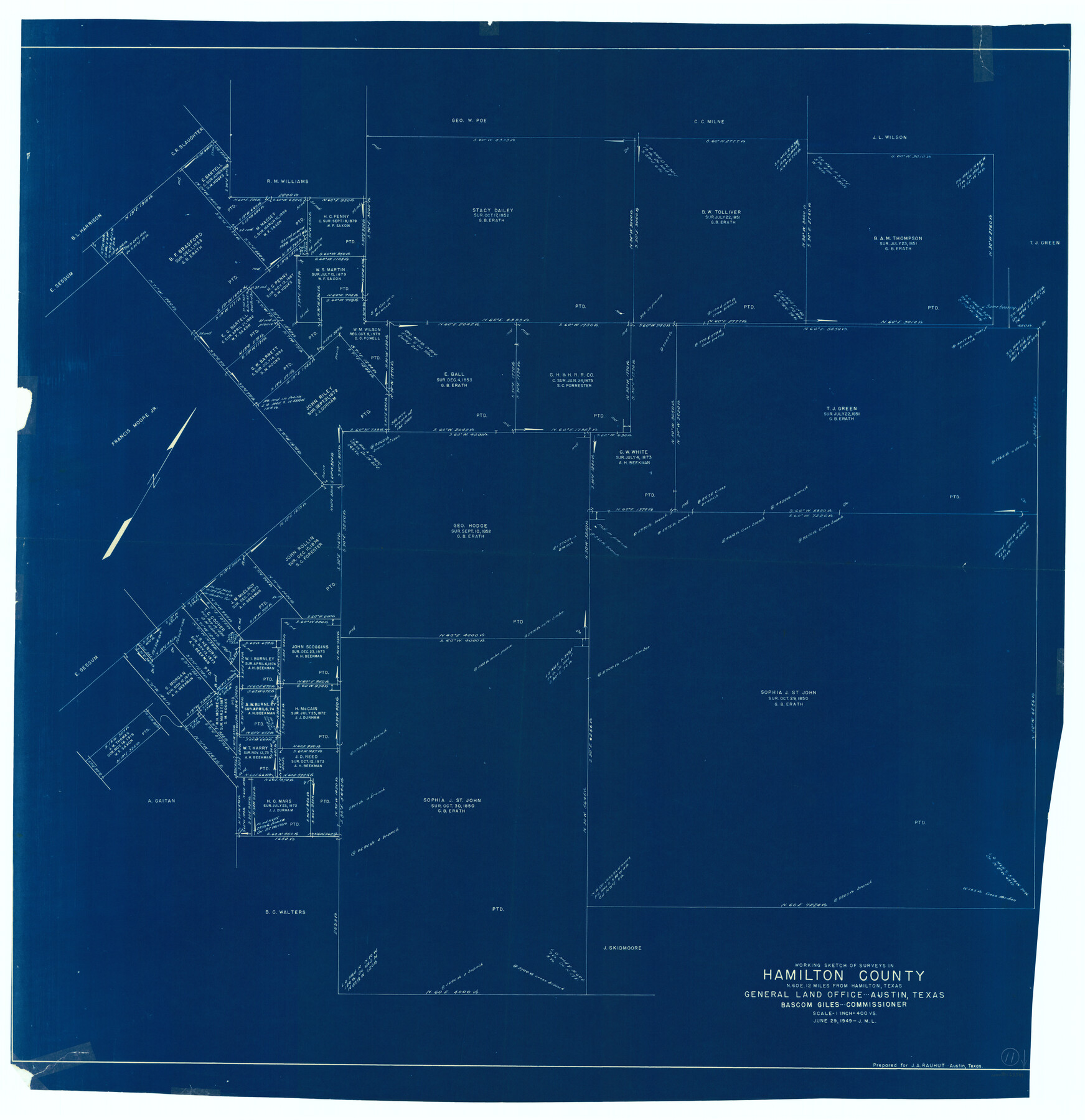
Hamilton County Working Sketch 11
-
Map/Doc
63349
-
Collection
General Map Collection
-
Object Dates
6/29/1949 (Creation Date)
-
Counties
Hamilton
-
Subjects
Surveying Working Sketch
-
Height x Width
45.1 x 43.7 inches
114.6 x 111.0 cm
-
Scale
1" = 400 varas
Part of: General Map Collection
Sherman County Rolled Sketch 8

Print $20.00
- Digital $50.00
Sherman County Rolled Sketch 8
Size 25.3 x 26.2 inches
Map/Doc 7788
Tarrant County

Print $40.00
- Digital $50.00
Tarrant County
1942
Size 48.6 x 37.8 inches
Map/Doc 73298
Map of the Paluxy Artesian Reservoirs of the Black and Grand Prairies of Texas including the Eastern and Western Cross Timbers

Print $20.00
- Digital $50.00
Map of the Paluxy Artesian Reservoirs of the Black and Grand Prairies of Texas including the Eastern and Western Cross Timbers
1900
Size 24.8 x 24.4 inches
Map/Doc 75919
Webb County Rolled Sketch EF4

Print $20.00
- Digital $50.00
Webb County Rolled Sketch EF4
1929
Size 33.2 x 24.4 inches
Map/Doc 8226
Oldham County Sketch File 4

Print $20.00
- Digital $50.00
Oldham County Sketch File 4
1883
Size 13.7 x 22.5 inches
Map/Doc 12111
No. IX - Outline map of the vicinity of Corpus Christi

Print $20.00
- Digital $50.00
No. IX - Outline map of the vicinity of Corpus Christi
Size 24.9 x 18.2 inches
Map/Doc 72966
A How to Get From Here to There Map and Water Too of Metropolitan Houston

A How to Get From Here to There Map and Water Too of Metropolitan Houston
Size 36.7 x 25.5 inches
Map/Doc 94362
Map of Falls County

Print $20.00
- Digital $50.00
Map of Falls County
1855
Size 21.4 x 23.9 inches
Map/Doc 3532
Henderson County Working Sketch 21

Print $20.00
- Digital $50.00
Henderson County Working Sketch 21
1948
Size 17.1 x 16.2 inches
Map/Doc 66154
Jasper County Working Sketch 13

Print $20.00
- Digital $50.00
Jasper County Working Sketch 13
1920
Size 24.3 x 17.1 inches
Map/Doc 66475
Pecos County Sketch File 53

Print $20.00
- Digital $50.00
Pecos County Sketch File 53
Size 18.0 x 38.9 inches
Map/Doc 10569
Floyd County Working Sketch 9

Print $20.00
- Digital $50.00
Floyd County Working Sketch 9
1952
Size 31.5 x 35.9 inches
Map/Doc 69188
You may also like
Flight Mission No. BRA-8M, Frame 76, Jefferson County

Print $20.00
- Digital $50.00
Flight Mission No. BRA-8M, Frame 76, Jefferson County
1953
Size 18.5 x 22.3 inches
Map/Doc 85596
Fayette County Boundary File 4

Print $19.00
- Digital $50.00
Fayette County Boundary File 4
Size 14.4 x 9.0 inches
Map/Doc 53362
[Townships 1 & 2, Blocks 56, 57]
![92927, [Townships 1 & 2, Blocks 56, 57], Twichell Survey Records](https://historictexasmaps.com/wmedia_w700/maps/92927-1.tif.jpg)
Print $20.00
- Digital $50.00
[Townships 1 & 2, Blocks 56, 57]
Size 19.7 x 22.8 inches
Map/Doc 92927
Anderson County Sketch File 4

Print $6.00
- Digital $50.00
Anderson County Sketch File 4
Size 8.7 x 6.4 inches
Map/Doc 12743
Menard County Rolled Sketch 7

Print $20.00
- Digital $50.00
Menard County Rolled Sketch 7
Size 43.2 x 37.3 inches
Map/Doc 9509
Armstrong County Sketch File A-10

Print $40.00
- Digital $50.00
Armstrong County Sketch File A-10
Size 22.6 x 35.6 inches
Map/Doc 10852
Sabine Bank to East Bay including Heald Bank

Print $20.00
- Digital $50.00
Sabine Bank to East Bay including Heald Bank
1957
Size 45.0 x 34.4 inches
Map/Doc 69846
Hood County Sketch File 23

Print $20.00
- Digital $50.00
Hood County Sketch File 23
Size 24.5 x 18.6 inches
Map/Doc 11780

Duval County Boundary File 3g

Print $4.00
- Digital $50.00
Duval County Boundary File 3g
Size 9.9 x 7.8 inches
Map/Doc 52747
Crockett County Working Sketch 19

Print $20.00
- Digital $50.00
Crockett County Working Sketch 19
1919
Size 23.7 x 17.7 inches
Map/Doc 68352
Jim Hogg County Rolled Sketch 9

Print $20.00
- Digital $50.00
Jim Hogg County Rolled Sketch 9
1974
Size 18.2 x 19.8 inches
Map/Doc 6443