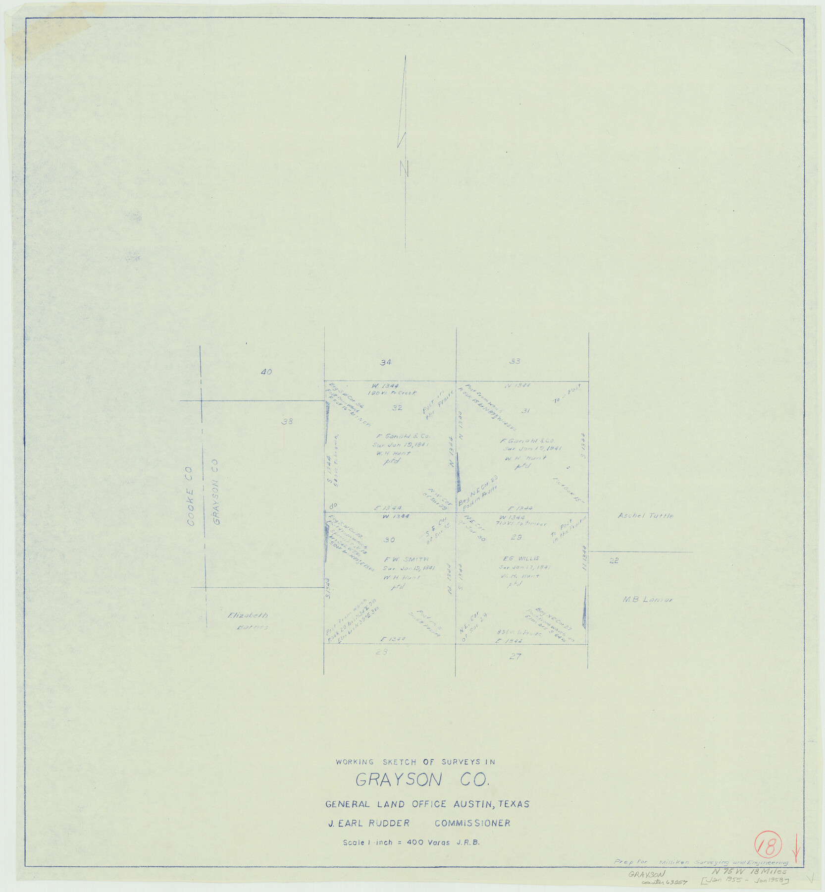
Grayson County Working Sketch 18
-
Map/Doc
63257
-
Collection
General Map Collection
-
Object Dates
1/1955 - 1/1958 (Creation Date)
-
Counties
Grayson
-
Subjects
Surveying Working Sketch
-
Height x Width
22.8 x 21.1 inches
57.9 x 53.6 cm
-
Scale
1" = 400 varas
Part of: General Map Collection
Burnet County Sketch File 1

Print $40.00
- Digital $50.00
Burnet County Sketch File 1
1847
Size 16.1 x 12.4 inches
Map/Doc 16670
Angelina County Sketch File 6

Print $4.00
- Digital $50.00
Angelina County Sketch File 6
1856
Size 8.1 x 8.2 inches
Map/Doc 12933
Dickens County

Print $20.00
- Digital $50.00
Dickens County
1877
Size 19.1 x 18.4 inches
Map/Doc 3486
Zavala County Sketch File 36

Print $6.00
- Digital $50.00
Zavala County Sketch File 36
1889
Size 10.9 x 8.2 inches
Map/Doc 41399
North Sulphur River, Mt. Joy Sheet

Print $20.00
- Digital $50.00
North Sulphur River, Mt. Joy Sheet
1926
Size 18.4 x 21.6 inches
Map/Doc 78333
Flight Mission No. BRA-7M, Frame 195, Jefferson County

Print $20.00
- Digital $50.00
Flight Mission No. BRA-7M, Frame 195, Jefferson County
1953
Size 18.5 x 22.4 inches
Map/Doc 85563
Comanche County Working Sketch 3

Print $20.00
- Digital $50.00
Comanche County Working Sketch 3
1919
Size 21.9 x 12.6 inches
Map/Doc 68137
La Salle County Working Sketch 20

Print $20.00
- Digital $50.00
La Salle County Working Sketch 20
1941
Size 23.7 x 29.9 inches
Map/Doc 70321
Mexico and Guatimala

Print $20.00
- Digital $50.00
Mexico and Guatimala
1828
Size 9.9 x 12.4 inches
Map/Doc 97276
Guadalupe County Sketch File 5

Print $4.00
- Digital $50.00
Guadalupe County Sketch File 5
1871
Size 8.1 x 10.0 inches
Map/Doc 24659
Nueces County Rolled Sketch 44

Print $40.00
- Digital $50.00
Nueces County Rolled Sketch 44
1948
Size 40.0 x 60.8 inches
Map/Doc 9602
Lighthouse establishment on the Atlantic and Gulf Coasts and coast signal stations

Print $20.00
- Digital $50.00
Lighthouse establishment on the Atlantic and Gulf Coasts and coast signal stations
1898
Size 24.9 x 18.3 inches
Map/Doc 73050
You may also like
Midland County

Print $20.00
- Digital $50.00
Midland County
1930
Size 44.9 x 38.5 inches
Map/Doc 73239
Ector County Sketch File 13

Print $16.00
- Digital $50.00
Ector County Sketch File 13
1988
Size 11.5 x 9.0 inches
Map/Doc 21651
Map of Deaf Smith Co.

Print $40.00
- Digital $50.00
Map of Deaf Smith Co.
1898
Size 42.5 x 54.6 inches
Map/Doc 16821
Lee County Working Sketch 18

Print $20.00
- Digital $50.00
Lee County Working Sketch 18
1989
Size 18.3 x 17.2 inches
Map/Doc 70397
Brewster County Working Sketch 9

Print $20.00
- Digital $50.00
Brewster County Working Sketch 9
1910
Size 14.3 x 14.4 inches
Map/Doc 67542
[Location Survey of the Southern Kansas Railway, Kiowa Extension from a point in Drake's Location, in Indian Territory 100 miles from south line of Kansas, continuing up Wolf Creek and South Canadian River to Cottonwood Creek in Hutchinson County]
![88844, [Location Survey of the Southern Kansas Railway, Kiowa Extension from a point in Drake's Location, in Indian Territory 100 miles from south line of Kansas, continuing up Wolf Creek and South Canadian River to Cottonwood Creek in Hutchinson County], General Map Collection](https://historictexasmaps.com/wmedia_w700/maps/88844.tif.jpg)
Print $20.00
- Digital $50.00
[Location Survey of the Southern Kansas Railway, Kiowa Extension from a point in Drake's Location, in Indian Territory 100 miles from south line of Kansas, continuing up Wolf Creek and South Canadian River to Cottonwood Creek in Hutchinson County]
1886
Size 39.0 x 40.0 inches
Map/Doc 88844

Harris County Rolled Sketch 46

Print $20.00
- Digital $50.00
Harris County Rolled Sketch 46
Size 18.1 x 24.8 inches
Map/Doc 6104
Shackelford County Boundary File 7a

Print $9.00
- Digital $50.00
Shackelford County Boundary File 7a
Size 14.9 x 9.4 inches
Map/Doc 58689
Flight Mission No. DIX-3P, Frame 170, Aransas County

Print $20.00
- Digital $50.00
Flight Mission No. DIX-3P, Frame 170, Aransas County
1956
Size 17.8 x 18.2 inches
Map/Doc 83776
Map of surveys 189 & 190, T. C. R.R. Co. in Travis County, Texas

Print $20.00
- Digital $50.00
Map of surveys 189 & 190, T. C. R.R. Co. in Travis County, Texas
1915
Size 18.5 x 25.0 inches
Map/Doc 75761
Brewster County Working Sketch 97

Print $20.00
- Digital $50.00
Brewster County Working Sketch 97
1978
Size 31.7 x 47.0 inches
Map/Doc 67697