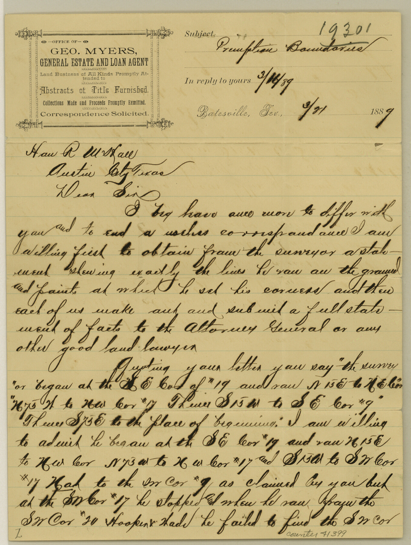
Zavala County Sketch File 36
[Letter to the GLO regarding locations of Pre-Emption surveys in the county]
-
Map/Doc
41399
-
Collection
General Map Collection
-
Object Dates
3/21/1889 (Creation Date)
-
People and Organizations
George Myers (Surveyor/Engineer)
-
Counties
Zavala
-
Subjects
Surveying Sketch File
-
Height x Width
10.9 x 8.2 inches
27.7 x 20.8 cm
-
Medium
paper, manuscript
Part of: General Map Collection
Flight Mission No. BRA-8M, Frame 24, Jefferson County

Print $20.00
- Digital $50.00
Flight Mission No. BRA-8M, Frame 24, Jefferson County
1953
Size 18.7 x 22.3 inches
Map/Doc 85579
Hansford County Sketch File 5

Print $20.00
- Digital $50.00
Hansford County Sketch File 5
1926
Size 19.0 x 23.0 inches
Map/Doc 11621
Garza County Rolled Sketch 6A

Print $20.00
- Digital $50.00
Garza County Rolled Sketch 6A
1902
Size 29.2 x 35.9 inches
Map/Doc 9053
Flight Mission No. BQR-9K, Frame 47, Brazoria County

Print $20.00
- Digital $50.00
Flight Mission No. BQR-9K, Frame 47, Brazoria County
1952
Size 18.7 x 22.4 inches
Map/Doc 84051
Flight Mission No. BQR-4K, Frame 70, Brazoria County

Print $20.00
- Digital $50.00
Flight Mission No. BQR-4K, Frame 70, Brazoria County
1952
Size 18.8 x 22.4 inches
Map/Doc 84003
Menard County Sketch File 30

Print $4.00
- Digital $50.00
Menard County Sketch File 30
1977
Size 14.3 x 8.6 inches
Map/Doc 31571
Jefferson County Rolled Sketch 32

Print $40.00
- Digital $50.00
Jefferson County Rolled Sketch 32
1955
Size 26.4 x 49.3 inches
Map/Doc 9295
Refugio County Sketch File 24

Print $12.00
- Digital $50.00
Refugio County Sketch File 24
1954
Size 14.4 x 8.9 inches
Map/Doc 35283
Galveston County NRC Article 33.136 Sketch 46

Print $23.00
- Digital $50.00
Galveston County NRC Article 33.136 Sketch 46
2007
Size 24.6 x 36.0 inches
Map/Doc 87936
Topographical Map of the Rio Grande, Sheet No. 28

Print $20.00
- Digital $50.00
Topographical Map of the Rio Grande, Sheet No. 28
1912
Map/Doc 89552
Hardin County Sketch File 9

Print $4.00
- Digital $50.00
Hardin County Sketch File 9
1865
Size 12.4 x 8.2 inches
Map/Doc 25106
Smith County Working Sketch 8

Print $20.00
- Digital $50.00
Smith County Working Sketch 8
1941
Size 28.9 x 22.7 inches
Map/Doc 63893
You may also like
Carta Esferica que comprehende las costas del Seno Mexicano construida de orden del rey en el deposito hidrografico de marina: Por disposicion del Exmo. Señor Don Juan de Langara, Secretario de Estado y del Despacho Universal de ella. Año de 1799.

Print $20.00
- Digital $50.00
Carta Esferica que comprehende las costas del Seno Mexicano construida de orden del rey en el deposito hidrografico de marina: Por disposicion del Exmo. Señor Don Juan de Langara, Secretario de Estado y del Despacho Universal de ella. Año de 1799.
1799
Size 25.9 x 37.3 inches
Map/Doc 95367
Collin County Sketch File 7

Print $40.00
- Digital $50.00
Collin County Sketch File 7
1852
Size 17.3 x 14.0 inches
Map/Doc 18866
Bee County Sketch File 25

Print $4.00
- Digital $50.00
Bee County Sketch File 25
1880
Size 11.0 x 8.2 inches
Map/Doc 14326
Wise County Working Sketch 7

Print $20.00
- Digital $50.00
Wise County Working Sketch 7
1950
Size 26.2 x 24.8 inches
Map/Doc 72621
Flight Mission No. CRC-1R, Frame 153, Chambers County

Print $20.00
- Digital $50.00
Flight Mission No. CRC-1R, Frame 153, Chambers County
1956
Size 18.8 x 22.5 inches
Map/Doc 84715
Lamb County Sketch File 9

Print $4.00
- Digital $50.00
Lamb County Sketch File 9
1910
Size 10.9 x 7.2 inches
Map/Doc 29358
San Patricio County Rolled Sketch 46E

Print $20.00
- Digital $50.00
San Patricio County Rolled Sketch 46E
1983
Size 17.4 x 46.3 inches
Map/Doc 8376
Starr County Boundary File 1

Print $24.00
- Digital $50.00
Starr County Boundary File 1
Size 13.0 x 8.5 inches
Map/Doc 58801
Map of the Texas & Pacific Railway and connections

Print $20.00
- Digital $50.00
Map of the Texas & Pacific Railway and connections
1903
Size 17.9 x 36.6 inches
Map/Doc 95767
Cottle County

Print $20.00
- Digital $50.00
Cottle County
1971
Size 42.5 x 35.7 inches
Map/Doc 73118
Hemphill County Working Sketch 29

Print $40.00
- Digital $50.00
Hemphill County Working Sketch 29
1974
Size 61.7 x 43.4 inches
Map/Doc 66124
Pecos County Rolled Sketch 147

Print $449.00
- Digital $50.00
Pecos County Rolled Sketch 147
1957
Size 10.1 x 15.4 inches
Map/Doc 48414