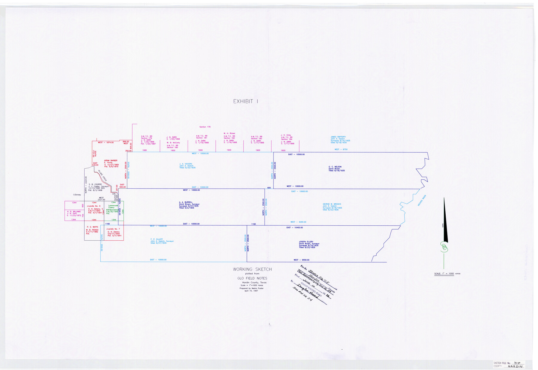
Hardin County Sketch File 71f
Working Sketch plotted from GLO field notes Hardin County, Texas
- 
                          Map/Doc11643
- 
                            CollectionGeneral Map Collection
- 
                            Object Dates1998/6/10 (File Date)1997/4/15 (Creation Date)
- 
                            People and OrganizationsNedra Foster (Draftsman)Darrell D. Shine (Surveyor/Engineer)
- 
                            CountiesHardin
- 
                            SubjectsSurveying Sketch File
- 
                            Height x Width25.2 x 36.7 inches64.0 x 93.2 cm
- 
                            Mediumpaper, print
- 
                            Scale1" = 1000 varas
- 
                            CommentsSee Hardin County Rolled Sketch 24 (6092)
 
 See Hardin County Sketch File 71 (25259) and 71e (11642)
- 
                            FeaturesVillage CreekNeches River
Related maps
            Hardin County Sketch File 71e


                                            Print $20.00                    
                                             -                         Digital $50.00                                    
                Hardin County Sketch File 71e
Size 25.2 x 37.1 inches
                                Map/Doc 11642
            
            Hardin County Sketch File 71


                                            Print $94.00                    
                                             -                         Digital $50.00                                    
                Hardin County Sketch File 71
1997
Size 11.4 x 8.8 inches
                                Map/Doc 25259
            
            Hardin County Rolled Sketch 24


                                            Print $20.00                    
                                             -                         Digital $50.00                                    
                Hardin County Rolled Sketch 24
1998
Size 27.2 x 38.6 inches
                                Map/Doc 6092
            Part of: General Map Collection
            Jack County Working Sketch 6


                                            Print $20.00                    
                                             -                         Digital $50.00                                    
                Jack County Working Sketch 6
1952
Size 29.1 x 24.3 inches
                                Map/Doc 66432
            
            Crockett County Working Sketch 85


                                            Print $40.00                    
                                             -                         Digital $50.00                                    
                Crockett County Working Sketch 85
1976
Size 23.4 x 54.8 inches
                                Map/Doc 68418
            
            El Paso County Rolled Sketch 43A


                                            Print $20.00                    
                                             -                         Digital $50.00                                    
                El Paso County Rolled Sketch 43A
Size 23.2 x 22.6 inches
                                Map/Doc 5829
            
            Uvalde County Sketch File 7


                                            Print $6.00                    
                                             -                         Digital $50.00                                    
                Uvalde County Sketch File 7
Size 14.5 x 11.4 inches
                                Map/Doc 38962
            
            Liberty County Working Sketch 74


                                            Print $20.00                    
                                             -                         Digital $50.00                                    
                Liberty County Working Sketch 74
1979
Size 38.8 x 35.4 inches
                                Map/Doc 70534
            
            Bell County Boundary File 3a


                                            Print $82.00                    
                                             -                         Digital $50.00                                    
                Bell County Boundary File 3a
Size 11.2 x 8.5 inches
                                Map/Doc 50502
            
            Map of that part of the boundary between the Republic of Texas and the United States, comprised between Logan's Ferry on the Sabine River and the 36th Mile Mound on the Meridian Line (Sheet No. 1)
            
                                    ![4671, Map of that part of the boundary between the Republic of Texas and the United States, comprised between Logan's Ferry on the Sabine River and the [3]6th Mile Mound on the [Meridian Line] (Sheet No. 1), General Map Collection](https://historictexasmaps.com/wmedia_w700/maps/4671-GC.tif.jpg) 


    ![4671, Map of that part of the boundary between the Republic of Texas and the United States, comprised between Logan's Ferry on the Sabine River and the [3]6th Mile Mound on the [Meridian Line] (Sheet No. 1), General Map Collection](https://historictexasmaps.com/wmedia_w700/maps/4671-GC.tif.jpg) 
                                
            
                                            Print $20.00                    
                                             -                         Digital $50.00                                    
                Map of that part of the boundary between the Republic of Texas and the United States, comprised between Logan's Ferry on the Sabine River and the 36th Mile Mound on the Meridian Line (Sheet No. 1)
1842
Size 34.6 x 26.4 inches
                                Map/Doc 4671
            
            Lipscomb County Boundary File 7


                                            Print $4.00                    
                                             -                         Digital $50.00                                    
                Lipscomb County Boundary File 7
Size 6.6 x 8.1 inches
                                Map/Doc 56331
            
            Aransas County Rolled Sketch 27


                                            Print $20.00                    
                                             -                         Digital $50.00                                    
                Aransas County Rolled Sketch 27
1983
Size 24.9 x 35.4 inches
                                Map/Doc 5059
            
            Cass County Working Sketch 47b


                                            Print $20.00                    
                                             -                         Digital $50.00                                    
                Cass County Working Sketch 47b
1992
Size 32.3 x 36.4 inches
                                Map/Doc 76063
            
            Anderson County Sketch File 27


                                            Print $40.00                    
                                             -                         Digital $50.00                                    
                Anderson County Sketch File 27
1970
Size 19.5 x 23.7 inches
                                Map/Doc 10806
            
            Hill County Sketch File 4 1/2


                                            Print $4.00                    
                                             -                         Digital $50.00                                    
                Hill County Sketch File 4 1/2
1859
Size 8.8 x 8.1 inches
                                Map/Doc 26468
            You may also like
            [Beaumont, Sour Lake and Western Ry. Right of Way and Alignment - Frisco]
            
                                    ![64112, [Beaumont, Sour Lake and Western Ry. Right of Way and Alignment - Frisco], General Map Collection](https://historictexasmaps.com/wmedia_w700/maps/64112.tif.jpg) 


    ![64112, [Beaumont, Sour Lake and Western Ry. Right of Way and Alignment - Frisco], General Map Collection](https://historictexasmaps.com/wmedia_w700/maps/64112.tif.jpg) 
                                
            
                                            Print $20.00                    
                                             -                         Digital $50.00                                    
                [Beaumont, Sour Lake and Western Ry. Right of Way and Alignment - Frisco]
1910
Size 20.3 x 46.0 inches
                                Map/Doc 64112
            
            Harris County Historic Topographic 23


                                            Print $20.00                    
                                             -                         Digital $50.00                                    
                Harris County Historic Topographic 23
1916
Size 29.2 x 22.6 inches
                                Map/Doc 65834
            
            Reeves County Working Sketch 43


                                            Print $20.00                    
                                             -                         Digital $50.00                                    
                Reeves County Working Sketch 43
1974
Size 43.2 x 37.1 inches
                                Map/Doc 63486
            
            Brewster County Rolled Sketch 101


                                            Print $40.00                    
                                             -                         Digital $50.00                                    
                Brewster County Rolled Sketch 101
1927
Size 74.2 x 42.3 inches
                                Map/Doc 9192
            
            Hutchinson County Rolled Sketch 43


                                            Print $40.00                    
                                             -                         Digital $50.00                                    
                Hutchinson County Rolled Sketch 43
1992
Size 38.0 x 49.4 inches
                                Map/Doc 6311
            
            Angelina County Sketch File 7


                                            Print $40.00                    
                                             -                         Digital $50.00                                    
                Angelina County Sketch File 7
1858
Size 15.5 x 35.8 inches
                                Map/Doc 10812
            
            Map of Bexar County


                                            Print $40.00                    
                                             -                         Digital $50.00                                    
                Map of Bexar County
1845
Size 90.6 x 81.0 inches
                                Map/Doc 82242
            
            Revised Plat, Section J, Tech Memorial Park, Inc., Infants Garden


                                            Print $20.00                    
                                             -                         Digital $50.00                                    
                Revised Plat, Section J, Tech Memorial Park, Inc., Infants Garden
1961
Size 29.1 x 33.7 inches
                                Map/Doc 92786
            
            Kerr County Sketch File 18


                                            Print $20.00                    
                                             -                         Digital $50.00                                    
                Kerr County Sketch File 18
1950
Size 16.9 x 20.3 inches
                                Map/Doc 11921
            
            Denton County Working Sketch 38


                                            Print $20.00                    
                                             -                         Digital $50.00                                    
                Denton County Working Sketch 38
2010
Size 23.4 x 29.5 inches
                                Map/Doc 89571
            
            Upton County Rolled Sketch 59A


                                            Print $20.00                    
                                             -                         Digital $50.00                                    
                Upton County Rolled Sketch 59A
Size 35.7 x 45.9 inches
                                Map/Doc 76423
             
                            