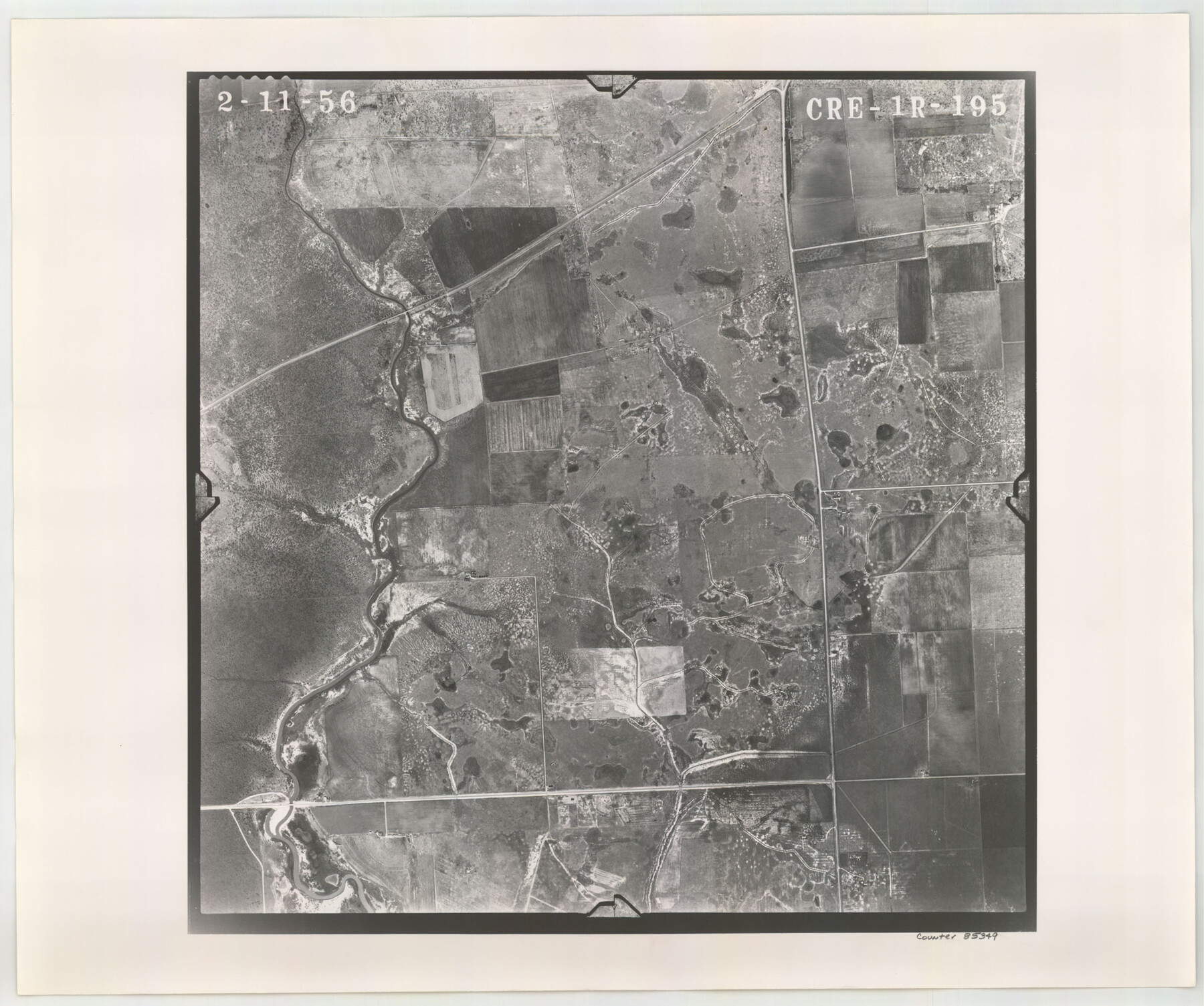
Flight Mission No. CRE-1R, Frame 195, Jackson County
CRE-1R-195
-
Map/Doc
85349
-
Collection
General Map Collection
-
Object Dates
1956/2/11 (Creation Date)
-
People and Organizations
U. S. Department of Agriculture (Publisher)
-
Counties
Jackson
-
Subjects
Aerial Photograph
-
Height x Width
18.6 x 22.3 inches
47.2 x 56.6 cm
-
Comments
Flown by Jack Ammann Photogrammetric Engineers of San Antonio, Texas.
Part of: General Map Collection
Coke County Sketch File 31

Print $4.00
- Digital $50.00
Coke County Sketch File 31
Size 14.1 x 8.8 inches
Map/Doc 18643
Crockett County Rolled Sketch 66

Print $20.00
- Digital $50.00
Crockett County Rolled Sketch 66
1947
Size 22.4 x 23.3 inches
Map/Doc 5609
Flight Mission No. DQO-1K, Frame 19, Galveston County

Print $20.00
- Digital $50.00
Flight Mission No. DQO-1K, Frame 19, Galveston County
1952
Size 18.9 x 22.6 inches
Map/Doc 84978
Sketch of Sabine Lake and Pass

Print $20.00
- Digital $50.00
Sketch of Sabine Lake and Pass
1840
Size 24.8 x 18.2 inches
Map/Doc 72725
Motley County Working Sketch 10

Print $20.00
- Digital $50.00
Motley County Working Sketch 10
1984
Size 33.1 x 29.0 inches
Map/Doc 71215
Flight Mission No. CON-2R, Frame 114, Stonewall County

Print $20.00
- Digital $50.00
Flight Mission No. CON-2R, Frame 114, Stonewall County
1957
Size 18.3 x 22.0 inches
Map/Doc 86989
Kenedy County Aerial Photograph Index Sheet 3

Print $20.00
- Digital $50.00
Kenedy County Aerial Photograph Index Sheet 3
1943
Size 23.5 x 18.4 inches
Map/Doc 83715
Map and Profile of the Proposed Route for the Michigan and Illinois Canal

Print $20.00
- Digital $50.00
Map and Profile of the Proposed Route for the Michigan and Illinois Canal
1830
Size 22.0 x 35.1 inches
Map/Doc 95692
Flight Mission No. CRC-3R, Frame 202, Chambers County

Print $20.00
- Digital $50.00
Flight Mission No. CRC-3R, Frame 202, Chambers County
1956
Size 18.7 x 22.4 inches
Map/Doc 84857
Texas, Matagorda Bay, Liveoak Bay

Print $40.00
- Digital $50.00
Texas, Matagorda Bay, Liveoak Bay
1933
Size 32.5 x 48.9 inches
Map/Doc 69992
Lamb County Rolled Sketch 7

Print $20.00
- Digital $50.00
Lamb County Rolled Sketch 7
Size 45.6 x 26.3 inches
Map/Doc 9415
Flight Mission No. BRA-16M, Frame 84, Jefferson County

Print $20.00
- Digital $50.00
Flight Mission No. BRA-16M, Frame 84, Jefferson County
1953
Size 18.6 x 22.1 inches
Map/Doc 85696
You may also like
Newton County Sketch File 4

Print $22.00
- Digital $50.00
Newton County Sketch File 4
1876
Size 8.0 x 12.8 inches
Map/Doc 32360
Presidio County Working Sketch 62

Print $3.00
- Digital $50.00
Presidio County Working Sketch 62
1958
Size 12.6 x 9.5 inches
Map/Doc 71739
"G" Sketch from Gaines County

Print $20.00
- Digital $50.00
"G" Sketch from Gaines County
1902
Size 31.6 x 21.8 inches
Map/Doc 90845
Map of that part of Comal County in Bexar District

Print $20.00
- Digital $50.00
Map of that part of Comal County in Bexar District
Size 16.3 x 22.1 inches
Map/Doc 3431
A Map of Part of Panola County [Judicial District]
![328, A Map of Part of Panola County [Judicial District], General Map Collection](https://historictexasmaps.com/wmedia_w700/maps/328.tif.jpg)
Print $20.00
- Digital $50.00
A Map of Part of Panola County [Judicial District]
1841
Size 18.3 x 15.4 inches
Map/Doc 328

Map of Burleson County, Texas

Print $20.00
- Digital $50.00
Map of Burleson County, Texas
1879
Size 16.1 x 21.1 inches
Map/Doc 667
Bandera County Sketch File 26

Print $6.00
- Digital $50.00
Bandera County Sketch File 26
1879
Size 7.7 x 8.3 inches
Map/Doc 14016
The Chief Justice County of Shelby. Undated

Print $20.00
The Chief Justice County of Shelby. Undated
2020
Size 23.5 x 21.7 inches
Map/Doc 96074
Hamilton County Boundary File 7

Print $32.00
- Digital $50.00
Hamilton County Boundary File 7
Size 17.6 x 11.4 inches
Map/Doc 54227
Blanco County Rolled Sketch 23

Print $20.00
- Digital $50.00
Blanco County Rolled Sketch 23
2019
Size 24.1 x 35.7 inches
Map/Doc 97346
Childress County Sketch File 12

Print $22.00
- Digital $50.00
Childress County Sketch File 12
Size 13.3 x 8.7 inches
Map/Doc 18255