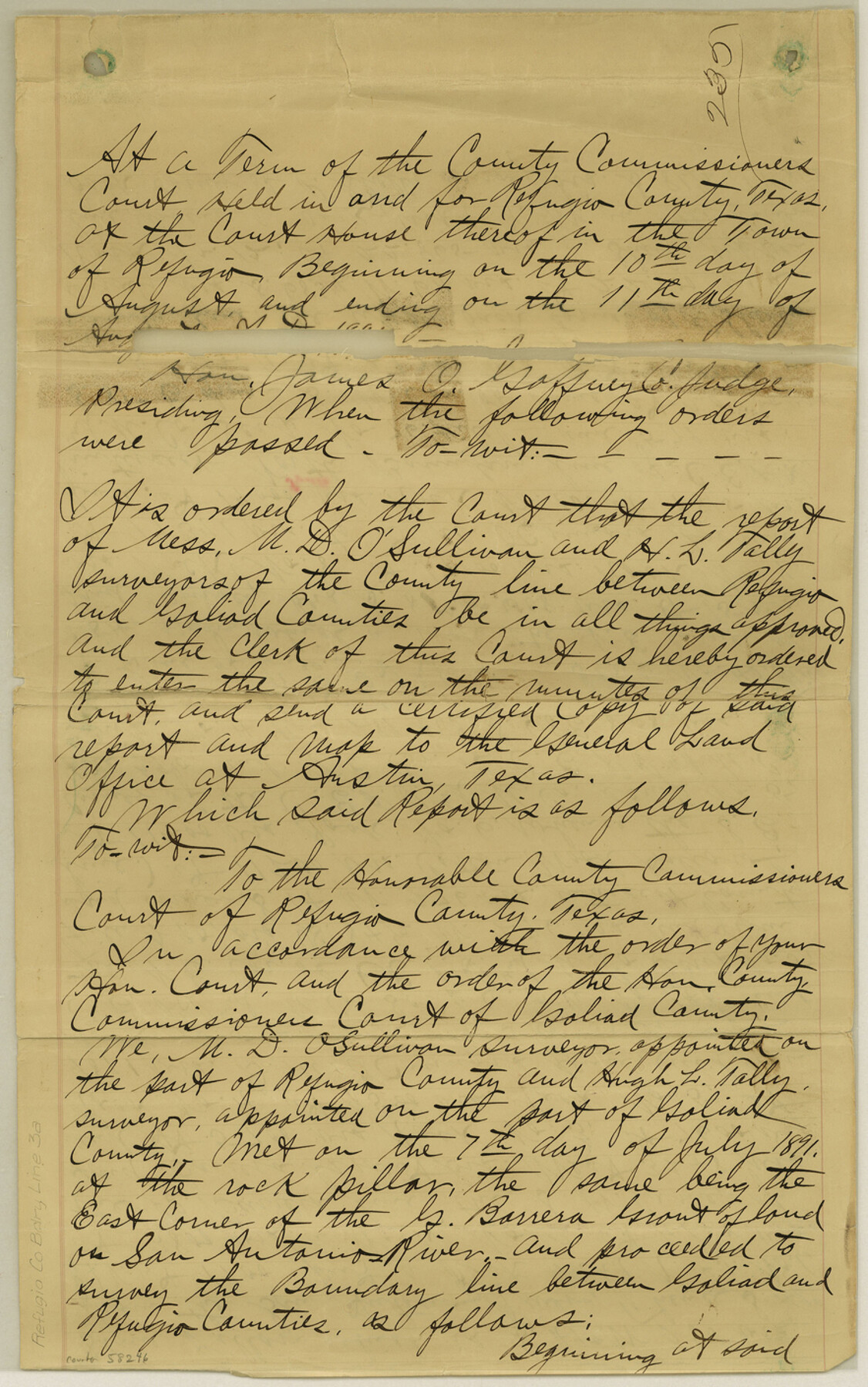
Refugio County Boundary File 3a
-
Map/Doc
58246
-
Collection
General Map Collection
-
Counties
Refugio
-
Subjects
County Boundaries
-
Height x Width
14.1 x 8.8 inches
35.8 x 22.4 cm
Part of: General Map Collection
Crane County Sketch File 28

Print $6.00
- Digital $50.00
Crane County Sketch File 28
1953
Size 11.5 x 9.1 inches
Map/Doc 19605
Panola County Working Sketch 38

Print $20.00
- Digital $50.00
Panola County Working Sketch 38
1991
Map/Doc 71447
Red River County Working Sketch 9

Print $20.00
- Digital $50.00
Red River County Working Sketch 9
1920
Size 15.2 x 18.9 inches
Map/Doc 71992
Flight Mission No. DCL-6C, Frame 97, Kenedy County

Print $20.00
- Digital $50.00
Flight Mission No. DCL-6C, Frame 97, Kenedy County
1943
Size 18.6 x 22.3 inches
Map/Doc 85927
Montgomery County Working Sketch 28

Print $20.00
- Digital $50.00
Montgomery County Working Sketch 28
1942
Size 21.9 x 44.1 inches
Map/Doc 71135
Blanco County Working Sketch 27

Print $20.00
- Digital $50.00
Blanco County Working Sketch 27
1969
Size 31.9 x 31.8 inches
Map/Doc 67387
Eastland County

Print $20.00
- Digital $50.00
Eastland County
1879
Size 21.3 x 21.3 inches
Map/Doc 3499
Fort Bend County Sketch File 30

Print $18.00
- Digital $50.00
Fort Bend County Sketch File 30
1920
Size 12.1 x 6.5 inches
Map/Doc 22988
Flight Mission No. DAG-23K, Frame 145, Matagorda County

Print $20.00
- Digital $50.00
Flight Mission No. DAG-23K, Frame 145, Matagorda County
1953
Size 15.7 x 15.8 inches
Map/Doc 86493
El Paso County Boundary File 27

Print $2.00
- Digital $50.00
El Paso County Boundary File 27
Size 7.3 x 5.6 inches
Map/Doc 53236
Dimmit County

Print $40.00
- Digital $50.00
Dimmit County
1976
Size 43.2 x 50.7 inches
Map/Doc 73133
Harrison County State Real Property Sketch 1

Print $20.00
- Digital $50.00
Harrison County State Real Property Sketch 1
1986
Size 24.2 x 25.4 inches
Map/Doc 61666
You may also like
![88940, Fisher Co[unty], Library of Congress](https://historictexasmaps.com/wmedia_w700/maps/88940.tif.jpg)

[Plat of Colorado River Survey, McCulloch County]
![2462, [Plat of Colorado River Survey, McCulloch County], General Map Collection](https://historictexasmaps.com/wmedia_w700/maps/2462-1.tif.jpg)
Print $40.00
- Digital $50.00
[Plat of Colorado River Survey, McCulloch County]
1918
Size 40.3 x 159.2 inches
Map/Doc 2462
Concho County Sketch File 39

Print $8.00
- Digital $50.00
Concho County Sketch File 39
1949
Size 11.3 x 8.8 inches
Map/Doc 19190
Montgomery County Working Sketch 65

Print $20.00
- Digital $50.00
Montgomery County Working Sketch 65
1965
Size 21.5 x 16.7 inches
Map/Doc 71172
Flight Mission No. BQY-4M, Frame 39, Harris County

Print $20.00
- Digital $50.00
Flight Mission No. BQY-4M, Frame 39, Harris County
1953
Size 18.6 x 22.3 inches
Map/Doc 85254
Throckmorton County Working Sketch 3

Print $20.00
- Digital $50.00
Throckmorton County Working Sketch 3
1924
Size 19.8 x 23.8 inches
Map/Doc 62112
Medina County Sketch File 2

Print $12.00
- Digital $50.00
Medina County Sketch File 2
Size 7.5 x 12.5 inches
Map/Doc 31439
[Leagues 657- 666, 671- 674, 685- 687]
![91070, [Leagues 657- 666, 671- 674, 685- 687], Twichell Survey Records](https://historictexasmaps.com/wmedia_w700/maps/91070-1.tif.jpg)
Print $20.00
- Digital $50.00
[Leagues 657- 666, 671- 674, 685- 687]
Size 35.8 x 25.6 inches
Map/Doc 91070
Maverick County Sketch File 4

Print $4.00
- Digital $50.00
Maverick County Sketch File 4
1876
Size 9.1 x 8.2 inches
Map/Doc 31051

Crockett County Working Sketch 75

Print $20.00
- Digital $50.00
Crockett County Working Sketch 75
1964
Size 25.7 x 24.0 inches
Map/Doc 68408