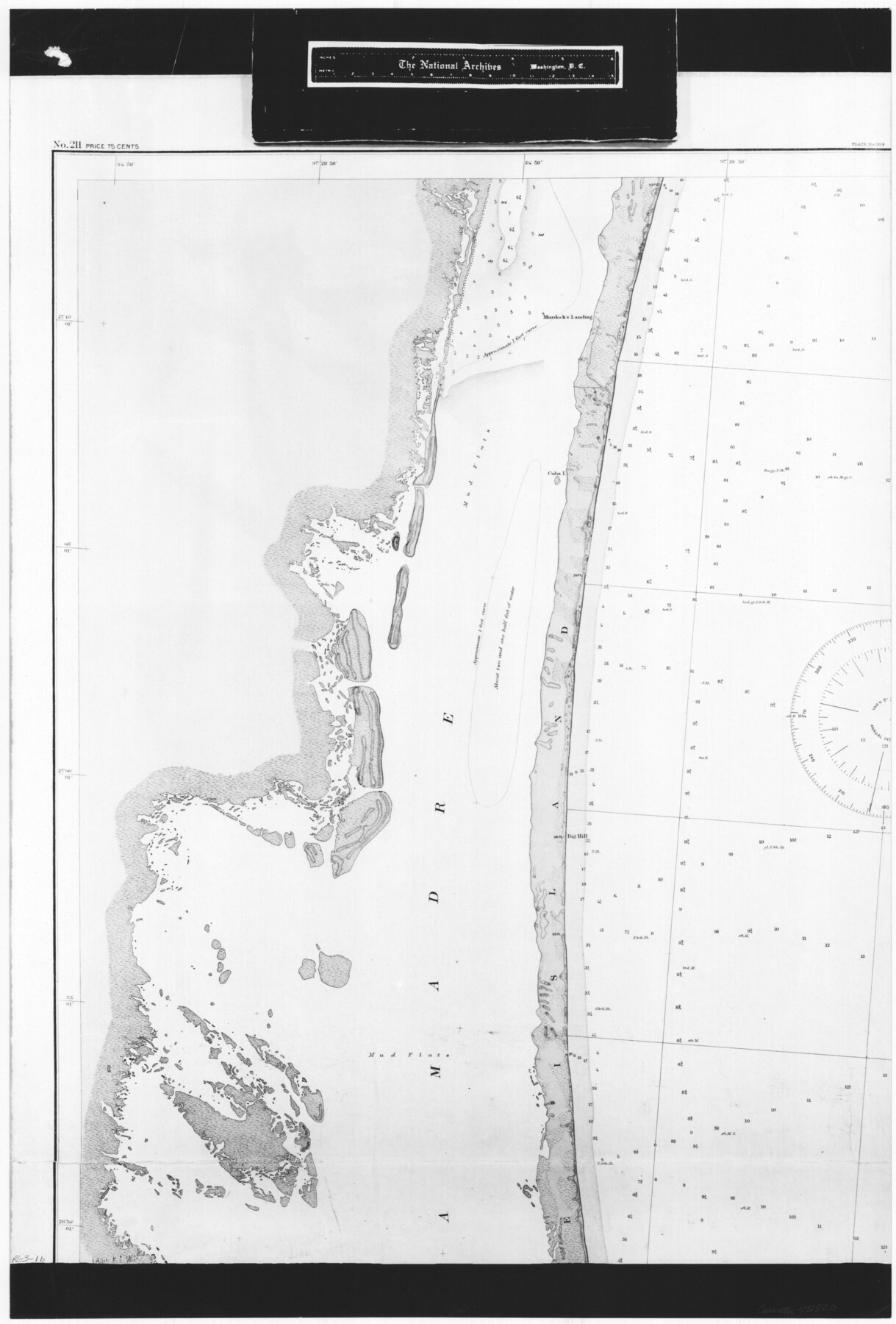
United States - Gulf Coast - Padre I. and Laguna Madre Lat. 27° 12' to Lat. 26° 33' Texas
RL-3-1b
-
Map/Doc
72820
-
Collection
General Map Collection
-
Object Dates
1913 (Creation Date)
-
People and Organizations
U. S. Coastal and Geodetic Survey (Publisher)
U. S. Engineers (Surveyor/Engineer)
-
Counties
Nueces
-
Subjects
Nautical Charts
-
Height x Width
26.9 x 18.2 inches
68.3 x 46.2 cm
-
Comments
B/W photostat copy from National Archives in multiple pieces.
Part of: General Map Collection
Marble Falls City, Burnet County, Texas

Print $20.00
- Digital $50.00
Marble Falls City, Burnet County, Texas
1890
Size 26.6 x 20.5 inches
Map/Doc 4830
Gaines County Rolled Sketch 31

Print $20.00
- Digital $50.00
Gaines County Rolled Sketch 31
1964
Size 20.2 x 25.5 inches
Map/Doc 5944
Denton County Sketch File 35

Print $14.00
- Digital $50.00
Denton County Sketch File 35
1897
Size 9.5 x 8.8 inches
Map/Doc 20766
Gaines County Working Sketch 22

Print $40.00
- Digital $50.00
Gaines County Working Sketch 22
1975
Size 52.5 x 33.9 inches
Map/Doc 69322
Cochran County Rolled Sketch 2

Print $20.00
- Digital $50.00
Cochran County Rolled Sketch 2
1940
Size 27.7 x 33.9 inches
Map/Doc 5500
Andrews County Rolled Sketch 21

Print $20.00
- Digital $50.00
Andrews County Rolled Sketch 21
Size 18.2 x 26.3 inches
Map/Doc 77169
[Surveys in the Liberty District in Tyler and Polk Counties]
![331, [Surveys in the Liberty District in Tyler and Polk Counties], General Map Collection](https://historictexasmaps.com/wmedia_w700/maps/331.tif.jpg)
Print $2.00
- Digital $50.00
[Surveys in the Liberty District in Tyler and Polk Counties]
1847
Size 5.9 x 8.4 inches
Map/Doc 331
Kinney County Sketch File 32

Print $6.00
- Digital $50.00
Kinney County Sketch File 32
1934
Size 11.2 x 8.8 inches
Map/Doc 29178
Aransas County Rolled Sketch 1

Print $40.00
- Digital $50.00
Aransas County Rolled Sketch 1
1930
Size 12.5 x 50.0 inches
Map/Doc 8915
Goliad County Working Sketch 21

Print $20.00
- Digital $50.00
Goliad County Working Sketch 21
1961
Size 42.9 x 39.6 inches
Map/Doc 63211
Lampasas County Sketch File 21

Print $14.00
- Digital $50.00
Lampasas County Sketch File 21
2001
Size 14.2 x 8.8 inches
Map/Doc 29436
Map of Padre Island Showing Location of Zoning Districts

Print $20.00
- Digital $50.00
Map of Padre Island Showing Location of Zoning Districts
1971
Size 26.2 x 18.5 inches
Map/Doc 4811
You may also like
East Part of Blk. No. 1, H. &G. N. R. R. Co. Survey

Print $40.00
- Digital $50.00
East Part of Blk. No. 1, H. &G. N. R. R. Co. Survey
Size 22.7 x 60.6 inches
Map/Doc 89626
[Area around Gillespie County, Bastrop County and El Paso County School Land Leagues]
![90866, [Area around Gillespie County, Bastrop County and El Paso County School Land Leagues], Twichell Survey Records](https://historictexasmaps.com/wmedia_w700/maps/90866-2.tif.jpg)
Print $20.00
- Digital $50.00
[Area around Gillespie County, Bastrop County and El Paso County School Land Leagues]
1886
Size 25.7 x 29.8 inches
Map/Doc 90866
Matagorda County Rolled Sketch 36

Print $115.00
- Digital $50.00
Matagorda County Rolled Sketch 36
1944
Size 10.1 x 15.0 inches
Map/Doc 46747
Crockett County Rolled Sketch 5

Print $40.00
- Digital $50.00
Crockett County Rolled Sketch 5
Size 25.0 x 63.0 inches
Map/Doc 8689
Comanche County Working Sketch 9

Print $20.00
- Digital $50.00
Comanche County Working Sketch 9
1954
Size 18.6 x 21.5 inches
Map/Doc 68143
Cass County Working Sketch 31

Print $20.00
- Digital $50.00
Cass County Working Sketch 31
1981
Size 30.7 x 31.1 inches
Map/Doc 67934
[Galveston, Harrisburg & San Antonio Railroad from Cuero to Stockdale]
![64188, [Galveston, Harrisburg & San Antonio Railroad from Cuero to Stockdale], General Map Collection](https://historictexasmaps.com/wmedia_w700/maps/64188.tif.jpg)
Print $20.00
- Digital $50.00
[Galveston, Harrisburg & San Antonio Railroad from Cuero to Stockdale]
1907
Size 13.8 x 34.0 inches
Map/Doc 64188
Outer Continental Shelf Leasing Maps (Texas Offshore Operations)

Print $20.00
- Digital $50.00
Outer Continental Shelf Leasing Maps (Texas Offshore Operations)
Size 29.9 x 21.7 inches
Map/Doc 75857
The Range and Ranch Cattle Area of the United States

Print $20.00
- Digital $50.00
The Range and Ranch Cattle Area of the United States
1884
Size 26.4 x 27.2 inches
Map/Doc 94077
United States - Gulf Coast - From Latitude 26° 33' to the Rio Grande Texas

Print $20.00
- Digital $50.00
United States - Gulf Coast - From Latitude 26° 33' to the Rio Grande Texas
1913
Size 27.8 x 18.4 inches
Map/Doc 72831
Stonewall County Sketch File 6

Print $10.00
- Digital $50.00
Stonewall County Sketch File 6
1891
Size 14.0 x 8.7 inches
Map/Doc 37208
[G. C. & S. F. Block S, E. L. & R. R. Block M and B9, D. & W. Block 24]
![91278, [G. C. & S. F. Block S, E. L. & R. R. Block M and B9, D. & W. Block 24], Twichell Survey Records](https://historictexasmaps.com/wmedia_w700/maps/91278-1.tif.jpg)
Print $20.00
- Digital $50.00
[G. C. & S. F. Block S, E. L. & R. R. Block M and B9, D. & W. Block 24]
Size 20.7 x 15.7 inches
Map/Doc 91278