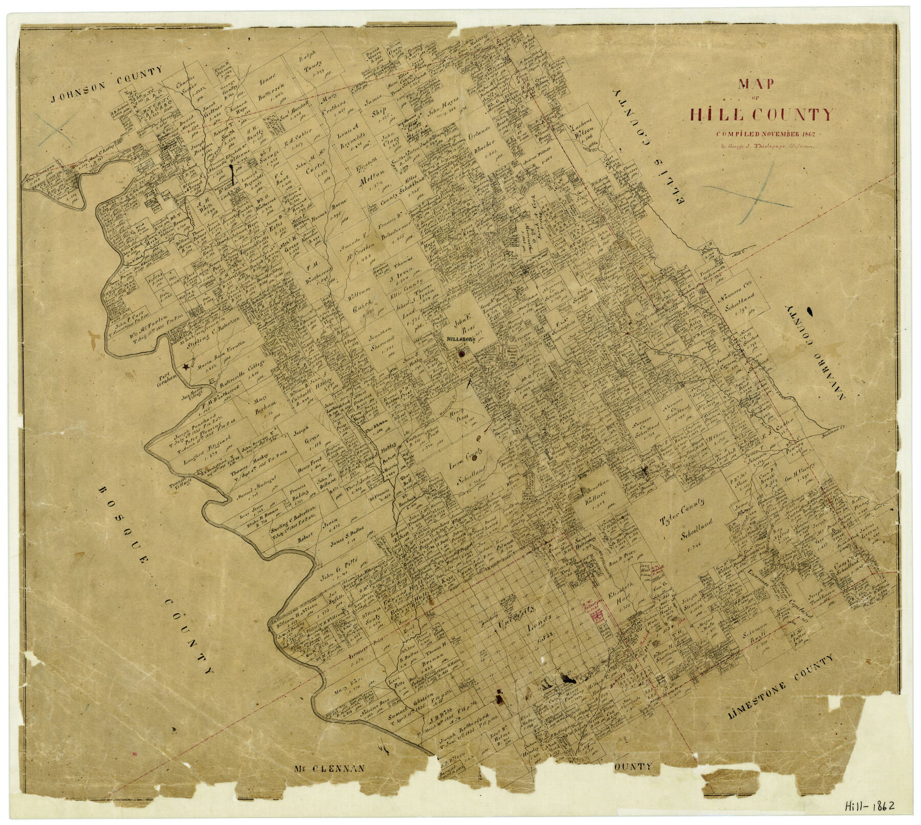
Map of Hill County
-
Map/Doc
3671
-
Collection
General Map Collection
-
Object Dates
11/1862 (Creation Date)
-
People and Organizations
George J. Thielepape (Compiler)
-
Counties
Hill
-
Subjects
County
-
Height x Width
22.1 x 24.7 inches
56.1 x 62.7 cm
-
Features
North Fork of Richland Creek
Wolf Creek
Bold Springs
Cottonwood Creek
Pin Oak Creek
Post Oak Creek
East Fork of Tahuacano Creek
Elingtons Creek
Towash Village
South Fork of Richland Creek
Aquilla Creek
Cobb Creek
Ash Creek
Rock Creek
Richland Creek
Caney's Creek
East Fork of Noland's Creek
Brumfield Creek
Hackberry Creek
Hillsboro
Bear Creek
Cedar Creek
Jose Maria Village
Camp Creek
Fort Graham
Battle Creek
Mill Creek
Uguila Creek
Noland's Creek
Part of: General Map Collection
San Jacinto County Working Sketch 14

Print $20.00
- Digital $50.00
San Jacinto County Working Sketch 14
1935
Size 25.6 x 26.4 inches
Map/Doc 63727
La Salle County Working Sketch 38

Print $20.00
- Digital $50.00
La Salle County Working Sketch 38
1961
Size 26.6 x 18.4 inches
Map/Doc 70339
Hardin County

Print $20.00
- Digital $50.00
Hardin County
1940
Size 40.7 x 37.7 inches
Map/Doc 77303
Panola County Sketch File 26

Print $20.00
- Digital $50.00
Panola County Sketch File 26
1944
Size 28.5 x 27.1 inches
Map/Doc 12141
Salado, South of Milam

Print $2.00
- Digital $50.00
Salado, South of Milam
1847
Size 11.4 x 8.5 inches
Map/Doc 359
Fannin County Rolled Sketch 18E

Print $2.00
- Digital $50.00
Fannin County Rolled Sketch 18E
Size 9.5 x 8.2 inches
Map/Doc 5872
Liberty County Working Sketch 80

Print $20.00
- Digital $50.00
Liberty County Working Sketch 80
1981
Size 34.6 x 41.7 inches
Map/Doc 70540
Jeff Davis County Sketch File 25b

Print $20.00
- Digital $50.00
Jeff Davis County Sketch File 25b
Size 18.9 x 20.0 inches
Map/Doc 11861
Red River County Sketch File 1a

Print $4.00
- Digital $50.00
Red River County Sketch File 1a
1854
Size 12.7 x 8.0 inches
Map/Doc 35093
Jeff Davis County Rolled Sketch 32

Print $20.00
- Digital $50.00
Jeff Davis County Rolled Sketch 32
1984
Size 16.3 x 24.5 inches
Map/Doc 7721
Brazos River, Brazos River Sheet 8

Print $4.00
- Digital $50.00
Brazos River, Brazos River Sheet 8
1926
Size 22.6 x 29.2 inches
Map/Doc 65301
Karnes County Sketch File 12

Print $14.00
- Digital $50.00
Karnes County Sketch File 12
1889
Size 12.7 x 8.0 inches
Map/Doc 28604
You may also like
Hudspeth County Working Sketch 31

Print $40.00
- Digital $50.00
Hudspeth County Working Sketch 31
1972
Size 56.2 x 41.2 inches
Map/Doc 66314
Titus County Boundary File 2

Print $6.00
- Digital $50.00
Titus County Boundary File 2
Size 7.7 x 6.7 inches
Map/Doc 59297
Houston County Sketch File 13

Print $6.00
- Digital $50.00
Houston County Sketch File 13
Size 9.0 x 7.8 inches
Map/Doc 26775
Edwards County Sketch File 34

Print $20.00
- Digital $50.00
Edwards County Sketch File 34
Size 16.8 x 19.0 inches
Map/Doc 11434
Flight Mission No. BQR-22K, Frame 35, Brazoria County

Print $20.00
- Digital $50.00
Flight Mission No. BQR-22K, Frame 35, Brazoria County
1953
Size 18.7 x 22.5 inches
Map/Doc 84119

Duval County Rolled Sketch 48

Print $20.00
- Digital $50.00
Duval County Rolled Sketch 48
Size 21.8 x 18.5 inches
Map/Doc 5762
The Republic County of Bexar. January 29, 1842

Print $20.00
The Republic County of Bexar. January 29, 1842
2020
Size 14.7 x 21.7 inches
Map/Doc 96099
[Blocks M-22 and M-25 and vicinity]
![91138, [Blocks M-22 and M-25 and vicinity], Twichell Survey Records](https://historictexasmaps.com/wmedia_w700/maps/91138-1.tif.jpg)
Print $20.00
- Digital $50.00
[Blocks M-22 and M-25 and vicinity]
Size 18.7 x 16.6 inches
Map/Doc 91138
Mills County Sketch File 28

Print $8.00
- Digital $50.00
Mills County Sketch File 28
2000
Size 14.3 x 8.7 inches
Map/Doc 31684
Liberty County Rolled Sketch M

Print $40.00
- Digital $50.00
Liberty County Rolled Sketch M
1953
Size 23.6 x 56.6 inches
Map/Doc 10651
Castro County Sketch File 4e

Print $4.00
- Digital $50.00
Castro County Sketch File 4e
Size 13.6 x 8.9 inches
Map/Doc 17473