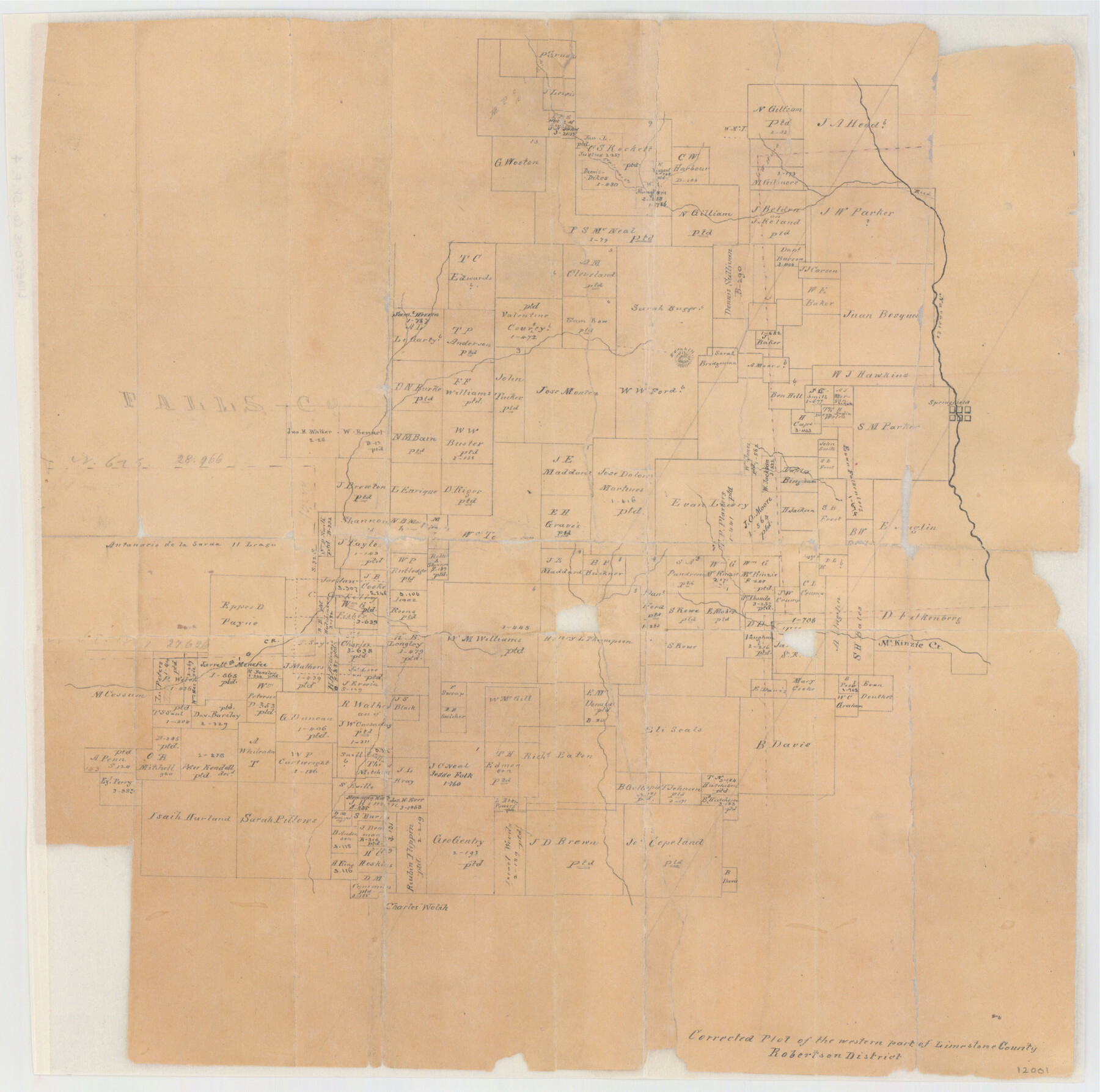
Limestone County Sketch File 4
Corrected Plot of the Western Part of Limestone County, Texas
-
Map/Doc
12001
-
Collection
General Map Collection
-
Object Dates
7/25/1847 (Creation Date)
7/1847 (Survey Date)
-
People and Organizations
C.C. Taylor (Surveyor/Engineer)
-
Counties
Limestone Falls
-
Subjects
Surveying Sketch File
-
Height x Width
15.2 x 34.1 inches
38.6 x 86.6 cm
-
Medium
paper, manuscript
-
Features
Crismas [sic] Creek
Springfield
Horn Hill
McKinzie Creek
Navisota [sic] River
Cairo
Part of: General Map Collection
Ector County Working Sketch 23

Print $40.00
- Digital $50.00
Ector County Working Sketch 23
1961
Size 55.9 x 43.3 inches
Map/Doc 68866
General Chart of the Coast No. XVI - Gulf Coast from Galveston to the Rio Grande

Print $20.00
- Digital $50.00
General Chart of the Coast No. XVI - Gulf Coast from Galveston to the Rio Grande
1883
Size 26.7 x 18.2 inches
Map/Doc 72735
Eastland County Sketch File 12

Print $10.00
- Digital $50.00
Eastland County Sketch File 12
1879
Size 9.3 x 8.4 inches
Map/Doc 21588
Flight Mission No. DCL-4C, Frame 146, Kenedy County

Print $20.00
- Digital $50.00
Flight Mission No. DCL-4C, Frame 146, Kenedy County
1943
Size 18.6 x 22.3 inches
Map/Doc 85824
Terrell County Working Sketch 15

Print $20.00
- Digital $50.00
Terrell County Working Sketch 15
1927
Size 18.7 x 19.8 inches
Map/Doc 62164
(A No. 2) Preliminary Sketch Showing the positions of Davis's South Shoal and other Dangers recently discovered by the Coast Survey and the soundings on the Old South Shoal, Bass Rip, Old Man, Pochick Rip &c.

Print $20.00
- Digital $50.00
(A No. 2) Preliminary Sketch Showing the positions of Davis's South Shoal and other Dangers recently discovered by the Coast Survey and the soundings on the Old South Shoal, Bass Rip, Old Man, Pochick Rip &c.
1846
Size 19.7 x 21.8 inches
Map/Doc 97203
Limestone County State Real Property Sketch 1

Print $20.00
- Digital $50.00
Limestone County State Real Property Sketch 1
2010
Size 35.9 x 24.6 inches
Map/Doc 89570
Palo Pinto County Working Sketch 8

Print $20.00
- Digital $50.00
Palo Pinto County Working Sketch 8
1922
Map/Doc 71391
Houston County Working Sketch 27

Print $20.00
- Digital $50.00
Houston County Working Sketch 27
1988
Size 34.9 x 28.5 inches
Map/Doc 66257
PSL Field Notes for Blocks 110 through 122 in Culberson County and Block 123 in Hudspeth County

PSL Field Notes for Blocks 110 through 122 in Culberson County and Block 123 in Hudspeth County
Map/Doc 81666
Presidio County Working Sketch 129

Print $4.00
- Digital $50.00
Presidio County Working Sketch 129
1988
Size 24.0 x 24.7 inches
Map/Doc 71807
Kleberg County

Print $20.00
- Digital $50.00
Kleberg County
1913
Size 27.0 x 33.9 inches
Map/Doc 95560
You may also like
Swisher County Sketch File 3

Print $20.00
- Digital $50.00
Swisher County Sketch File 3
1896
Size 17.2 x 16.1 inches
Map/Doc 12403
Bexar County Rolled Sketch 2
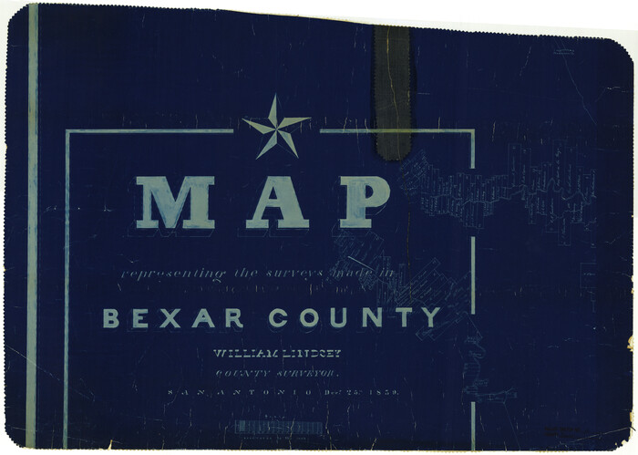
Print $20.00
- Digital $50.00
Bexar County Rolled Sketch 2
1839
Size 23.2 x 32.5 inches
Map/Doc 5135
San Patricio County Sketch File 54

Print $86.00
- Digital $50.00
San Patricio County Sketch File 54
1997
Size 11.0 x 8.5 inches
Map/Doc 41769
Limestone County Sketch File 27

Print $20.00
- Digital $50.00
Limestone County Sketch File 27
Size 23.2 x 18.8 inches
Map/Doc 12004
Garza County Rolled Sketch 5

Print $40.00
- Digital $50.00
Garza County Rolled Sketch 5
1906
Size 37.2 x 48.0 inches
Map/Doc 9050
Flight Mission No. DIX-8P, Frame 90, Aransas County

Print $20.00
- Digital $50.00
Flight Mission No. DIX-8P, Frame 90, Aransas County
1956
Size 18.6 x 22.4 inches
Map/Doc 83915
Sutton County Working Sketch 27

Print $20.00
- Digital $50.00
Sutton County Working Sketch 27
1891
Size 23.2 x 18.6 inches
Map/Doc 62370
Lee County Working Sketch 12

Print $20.00
- Digital $50.00
Lee County Working Sketch 12
1980
Size 12.3 x 16.3 inches
Map/Doc 70391
Harris County Working Sketch 70

Print $20.00
- Digital $50.00
Harris County Working Sketch 70
1956
Size 25.5 x 32.9 inches
Map/Doc 65962
Mileage Map of the Transcontinental Trails of the United States showing best roads, road distances, principal cities

Print $20.00
- Digital $50.00
Mileage Map of the Transcontinental Trails of the United States showing best roads, road distances, principal cities
1920
Size 10.8 x 12.8 inches
Map/Doc 95899
Brazoria County NRC Article 33.136 Sketch 21

Print $34.00
Brazoria County NRC Article 33.136 Sketch 21
2018
Map/Doc 97241
Presidio County Rolled Sketch 106

Print $20.00
- Digital $50.00
Presidio County Rolled Sketch 106
1955
Size 23.0 x 36.4 inches
Map/Doc 7387