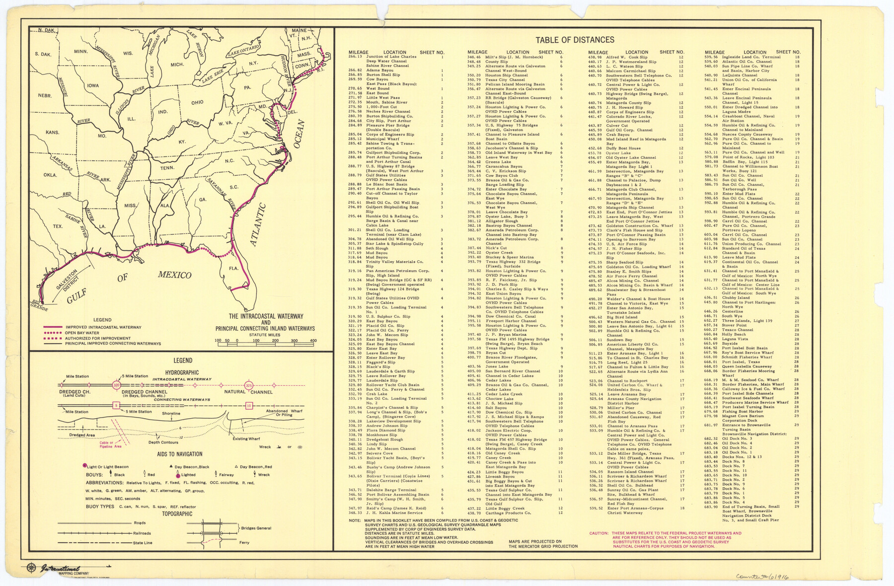
Maps of Gulf Intracoastal Waterway, Texas - Sabine River to the Rio Grande and connecting waterways including ship channels
-
Map/Doc
61916
-
Collection
General Map Collection
-
Object Dates
1966 (Creation Date)
-
Subjects
Intracoastal Waterways
-
Height x Width
14.6 x 22.3 inches
37.1 x 56.6 cm
Part of: General Map Collection
Travis County Rolled Sketch 58

Print $20.00
- Digital $50.00
Travis County Rolled Sketch 58
Size 37.4 x 25.5 inches
Map/Doc 8049
Crockett County Sketch File KL

Print $20.00
- Digital $50.00
Crockett County Sketch File KL
1925
Size 30.0 x 28.7 inches
Map/Doc 11243
Mitchell County

Print $20.00
- Digital $50.00
Mitchell County
1922
Size 43.4 x 38.2 inches
Map/Doc 66936
Jefferson County Working Sketch 1

Print $20.00
- Digital $50.00
Jefferson County Working Sketch 1
Size 22.7 x 17.5 inches
Map/Doc 66544
Anderson County Working Sketch 5

Print $20.00
- Digital $50.00
Anderson County Working Sketch 5
1913
Size 15.0 x 15.3 inches
Map/Doc 67004
Burnet County Sketch File 46

Print $4.00
- Digital $50.00
Burnet County Sketch File 46
1873
Size 12.8 x 8.5 inches
Map/Doc 16773
Reagan County Boundary File 1d

Print $36.00
- Digital $50.00
Reagan County Boundary File 1d
Size 9.2 x 8.3 inches
Map/Doc 58181
Sutton County Working Sketch 38

Print $20.00
- Digital $50.00
Sutton County Working Sketch 38
1942
Size 35.2 x 26.1 inches
Map/Doc 62381
Hartley County Rolled Sketch 2

Print $20.00
- Digital $50.00
Hartley County Rolled Sketch 2
Size 41.2 x 27.6 inches
Map/Doc 6158
Nueces County Sketch File 60

Print $14.00
- Digital $50.00
Nueces County Sketch File 60
1940
Size 11.1 x 8.8 inches
Map/Doc 32962
Travis County

Print $40.00
- Digital $50.00
Travis County
1936
Size 47.0 x 53.7 inches
Map/Doc 73305
Flight Mission No. DQO-8K, Frame 67, Galveston County

Print $20.00
- Digital $50.00
Flight Mission No. DQO-8K, Frame 67, Galveston County
1952
Size 18.9 x 22.4 inches
Map/Doc 85171
You may also like
The Republic County of Sabine. December 29, 1845

Print $20.00
The Republic County of Sabine. December 29, 1845
2020
Size 17.6 x 21.7 inches
Map/Doc 96270

Presidio County Sketch File 69b

Print $6.00
- Digital $50.00
Presidio County Sketch File 69b
1919
Size 11.2 x 8.8 inches
Map/Doc 34666
[Leagues 486-494, 503-539]
![93099, [Leagues 486-494, 503-539], Twichell Survey Records](https://historictexasmaps.com/wmedia_w700/maps/93099-1.tif.jpg)
Print $20.00
- Digital $50.00
[Leagues 486-494, 503-539]
Size 31.8 x 19.9 inches
Map/Doc 93099

Flight Mission No. CGI-3N, Frame 77, Cameron County

Print $20.00
- Digital $50.00
Flight Mission No. CGI-3N, Frame 77, Cameron County
1954
Size 18.6 x 22.2 inches
Map/Doc 84571
[River Meander along Jas. Tobin Survey and others]
![89814, [River Meander along Jas. Tobin Survey and others], Twichell Survey Records](https://historictexasmaps.com/wmedia_w700/maps/89814-1.tif.jpg)
Print $40.00
- Digital $50.00
[River Meander along Jas. Tobin Survey and others]
Size 73.6 x 43.9 inches
Map/Doc 89814
Foard County Sketch File 19

Print $20.00
- Digital $50.00
Foard County Sketch File 19
1899
Size 17.7 x 16.5 inches
Map/Doc 11493
Texas, an Agricultural Empire

Texas, an Agricultural Empire
1915
Size 10.8 x 8.0 inches
Map/Doc 96593

Shackelford County Rolled Sketch 2

Print $40.00
- Digital $50.00
Shackelford County Rolled Sketch 2
Size 18.9 x 51.9 inches
Map/Doc 75935
Subdivision of Capitol Leagues 112, 113, 114, and 115, and Parts of 110, and 111

Print $20.00
- Digital $50.00
Subdivision of Capitol Leagues 112, 113, 114, and 115, and Parts of 110, and 111
1906
Size 18.5 x 23.3 inches
Map/Doc 92583