Fort Bend County State Real Property Sketch 1
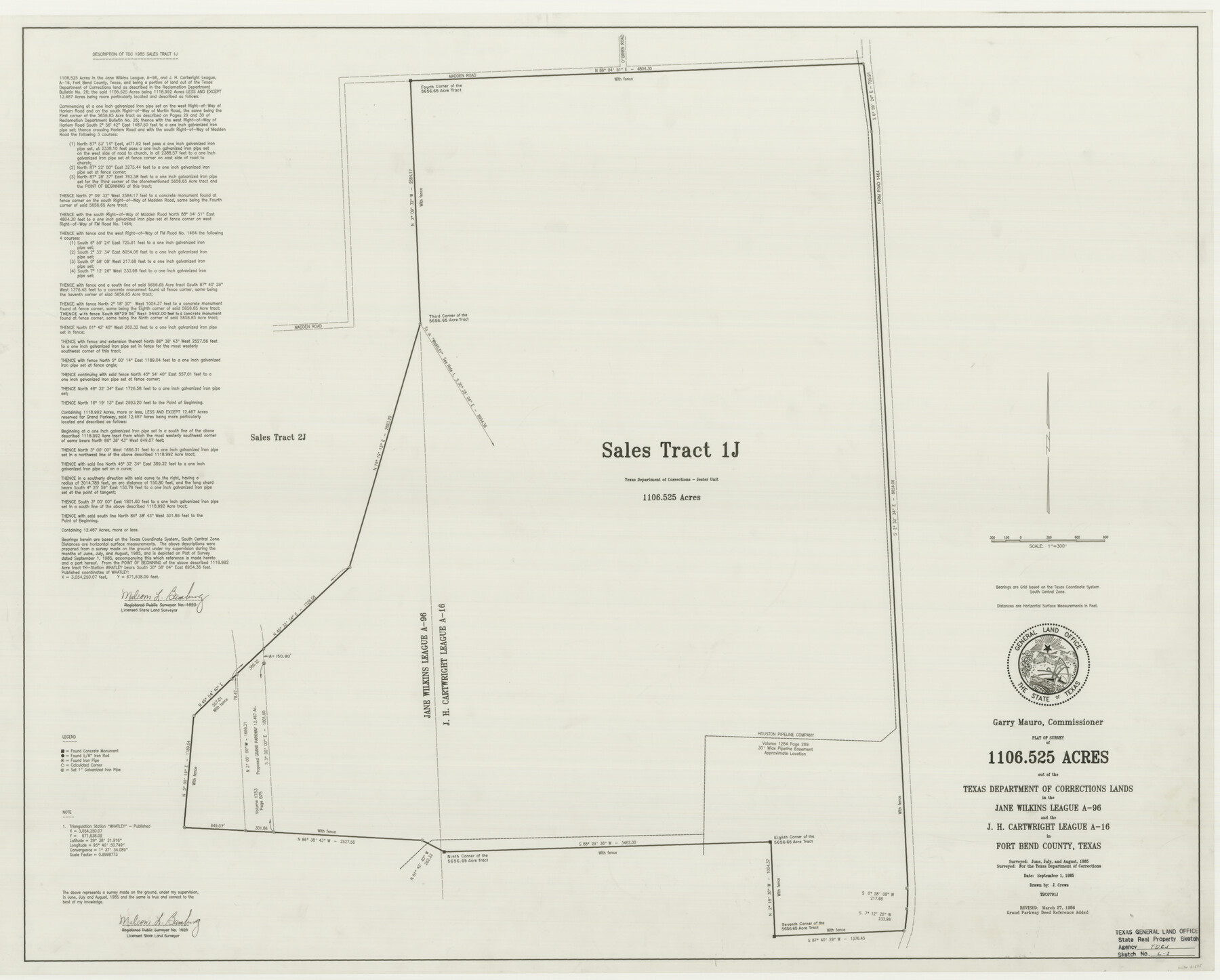
A Plat of a Survey of 1106.525 Acres Out of the Texas Department of Corrections Lands, Jester Unit, in the Jane Wilkins League, A - 96 and the J. H. Cartwright League, A - 16, Sales Tract 1J
State Real Property Sketch S - 1
-
Map/Doc
61675
-
Collection
General Map Collection
-
Object Dates
1986/3/27 (Creation Date)
-
People and Organizations
Texas General Land Office (Publisher)
Texas General Land Office (Printer)
J. Crews (Compiler)
Garry Mauro (GLO Commissioner)
J. Crews (Draftsman)
Malcom L. Bamburg (Surveyor/Engineer)
-
Counties
Fort Bend
-
Subjects
State Real Property
-
Height x Width
34.7 x 43.2 inches
88.1 x 109.7 cm
-
Comments
Surveyed in June, July, and August 1985.
Surveys located about six miles North 59 degrees East of Richmond, Texas.
Part of: General Map Collection
Houston County Rolled Sketch 6

Print $40.00
- Digital $50.00
Houston County Rolled Sketch 6
1963
Size 48.0 x 34.3 inches
Map/Doc 9182
Palo Pinto County Sketch File 29

Print $40.00
- Digital $50.00
Palo Pinto County Sketch File 29
1874
Size 12.8 x 16.0 inches
Map/Doc 33419
Red River, Bois D'Arc Creek Floodway Sheet No. 3

Print $20.00
- Digital $50.00
Red River, Bois D'Arc Creek Floodway Sheet No. 3
1917
Size 28.8 x 22.0 inches
Map/Doc 69658
Amistad International Reservoir on Rio Grande 73

Print $20.00
- Digital $50.00
Amistad International Reservoir on Rio Grande 73
1949
Size 28.5 x 40.1 inches
Map/Doc 73362
Fort Bend County Working Sketch 24

Print $20.00
- Digital $50.00
Fort Bend County Working Sketch 24
1981
Size 27.1 x 30.5 inches
Map/Doc 69230
University Land in Cooke County

Print $20.00
- Digital $50.00
University Land in Cooke County
1906
Size 23.6 x 30.0 inches
Map/Doc 2425
Bandera County Rolled Sketch 6

Print $40.00
- Digital $50.00
Bandera County Rolled Sketch 6
Size 55.8 x 41.1 inches
Map/Doc 8439
Gonzales County Working Sketch 11
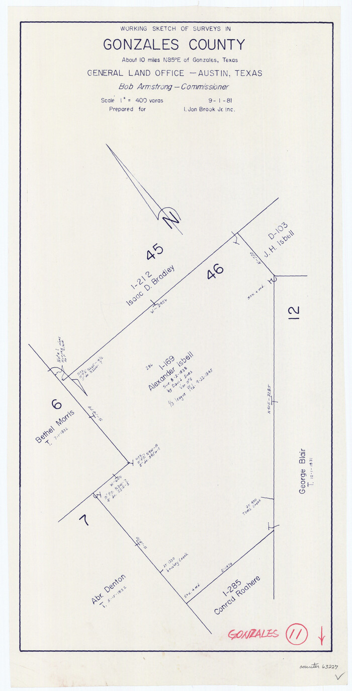
Print $20.00
- Digital $50.00
Gonzales County Working Sketch 11
1981
Size 22.2 x 11.3 inches
Map/Doc 63227
Travis County Sketch File 47

Print $6.00
- Digital $50.00
Travis County Sketch File 47
1939
Size 14.3 x 8.9 inches
Map/Doc 38374
Polk County Sketch File 14a

Print $4.00
- Digital $50.00
Polk County Sketch File 14a
1863
Size 9.0 x 14.6 inches
Map/Doc 34155
Pecos County Rolled Sketch 25 1/2

Print $20.00
- Digital $50.00
Pecos County Rolled Sketch 25 1/2
1888
Size 41.9 x 39.2 inches
Map/Doc 9688
Hall County Rolled Sketch 7

Print $20.00
- Digital $50.00
Hall County Rolled Sketch 7
Size 9.2 x 26.4 inches
Map/Doc 6051
You may also like
Flight Mission No. CRC-4R, Frame 104, Chambers County

Print $20.00
- Digital $50.00
Flight Mission No. CRC-4R, Frame 104, Chambers County
1956
Size 18.6 x 22.4 inches
Map/Doc 84901
Tarrant County

Print $20.00
- Digital $50.00
Tarrant County
1883
Size 35.5 x 32.8 inches
Map/Doc 4676
Crosby County Working Sketch 10

Print $20.00
- Digital $50.00
Crosby County Working Sketch 10
1946
Size 44.5 x 23.7 inches
Map/Doc 68444
Brewster County Rolled Sketch 124

Print $20.00
- Digital $50.00
Brewster County Rolled Sketch 124
1975
Size 15.8 x 13.2 inches
Map/Doc 5299
Roberts County Working Sketch 43

Print $20.00
- Digital $50.00
Roberts County Working Sketch 43
1990
Size 19.3 x 37.6 inches
Map/Doc 63569
Polk County Working Sketch 2

Print $20.00
- Digital $50.00
Polk County Working Sketch 2
1909
Size 27.7 x 20.1 inches
Map/Doc 71617
Ward County Working Sketch 13

Print $20.00
- Digital $50.00
Ward County Working Sketch 13
1947
Size 20.0 x 40.6 inches
Map/Doc 72319
Val Verde County Rolled Sketch 63

Print $20.00
- Digital $50.00
Val Verde County Rolled Sketch 63
1956
Size 37.5 x 41.8 inches
Map/Doc 10082
La Salle County Rolled Sketch 21

Print $77.00
- Digital $50.00
La Salle County Rolled Sketch 21
1955
Size 10.0 x 15.1 inches
Map/Doc 46461
Oldham County Sketch File 14

Print $20.00
- Digital $50.00
Oldham County Sketch File 14
1904
Size 20.0 x 24.6 inches
Map/Doc 12115
Edwards County Rolled Sketch 20

Print $20.00
- Digital $50.00
Edwards County Rolled Sketch 20
1947
Size 31.6 x 40.4 inches
Map/Doc 8844
Sterling County Rolled Sketch 33

Print $20.00
- Digital $50.00
Sterling County Rolled Sketch 33
Size 16.6 x 12.3 inches
Map/Doc 7857