Fort Bend County State Real Property Sketch 17
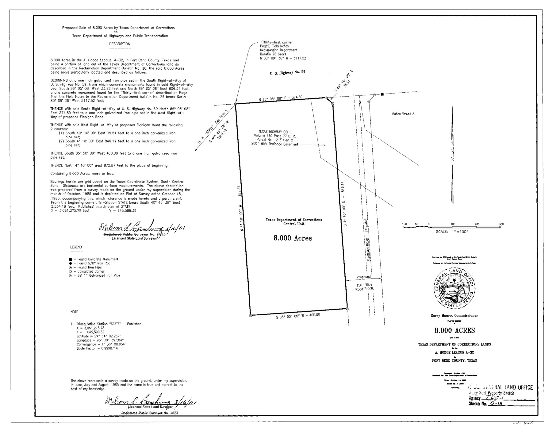
A Plat of a Survey of 8.000 Acres Out of the Texas Department of Corrections Lands, Central Unit, A. Hodge League, A - 32
State Real Property Sketch S - 19
-
Map/Doc
61665
-
Collection
General Map Collection
-
Object Dates
1985/10/18 (Creation Date)
-
People and Organizations
Texas General Land Office (Publisher)
Texas General Land Office (Printer)
J. Crews (Draftsman)
J. Crews (Compiler)
Garry Mauro (GLO Commissioner)
Malcom L. Bamburg (Surveyor/Engineer)
-
Counties
Fort Bend
-
Subjects
State Real Property
-
Height x Width
17.8 x 22.8 inches
45.2 x 57.9 cm
-
Comments
Surveys located about seven and one half miles North 70 degrees East of Richmond, Texas.
Part of: General Map Collection
Real County Working Sketch 61

Print $20.00
- Digital $50.00
Real County Working Sketch 61
1964
Size 37.9 x 44.5 inches
Map/Doc 71953
[Map of the Location Survey of the Hearne & Brazos Valley Railroad]
![64348, [Map of the Location Survey of the Hearne & Brazos Valley Railroad], General Map Collection](https://historictexasmaps.com/wmedia_w700/maps/64348.tif.jpg)
Print $40.00
- Digital $50.00
[Map of the Location Survey of the Hearne & Brazos Valley Railroad]
1891
Size 38.4 x 65.1 inches
Map/Doc 64348
Ward County Rolled Sketch 7

Print $40.00
- Digital $50.00
Ward County Rolled Sketch 7
1907
Size 33.9 x 91.0 inches
Map/Doc 10103
Edwards County Working Sketch 101

Print $20.00
- Digital $50.00
Edwards County Working Sketch 101
1971
Size 36.9 x 38.8 inches
Map/Doc 68977
Hudspeth County Sketch File 21a

Print $10.00
- Digital $50.00
Hudspeth County Sketch File 21a
Size 10.6 x 8.4 inches
Map/Doc 26969
Coleman County Working Sketch 9

Print $20.00
- Digital $50.00
Coleman County Working Sketch 9
1950
Size 24.9 x 30.5 inches
Map/Doc 68075
Hays County Sketch File 18

Print $4.00
- Digital $50.00
Hays County Sketch File 18
1878
Size 13.0 x 8.1 inches
Map/Doc 26235
Kent County Boundary File 10

Print $16.00
- Digital $50.00
Kent County Boundary File 10
Size 14.0 x 8.8 inches
Map/Doc 55887
[Map showing resurvey of Capitol Leagues, Hartley County, Texas]
![1760, [Map showing resurvey of Capitol Leagues, Hartley County, Texas], General Map Collection](https://historictexasmaps.com/wmedia_w700/maps/1760-1.tif.jpg)
Print $20.00
- Digital $50.00
[Map showing resurvey of Capitol Leagues, Hartley County, Texas]
1918
Size 30.6 x 47.8 inches
Map/Doc 1760
[Right of Way Map, Belton Branch of the M.K.&T. RR.]
![64224, [Right of Way Map, Belton Branch of the M.K.&T. RR.], General Map Collection](https://historictexasmaps.com/wmedia_w700/maps/64224.tif.jpg)
Print $20.00
- Digital $50.00
[Right of Way Map, Belton Branch of the M.K.&T. RR.]
1896
Size 7.1 x 20.6 inches
Map/Doc 64224
Burnet County Boundary File 12b

Print $8.00
- Digital $50.00
Burnet County Boundary File 12b
Size 12.8 x 8.4 inches
Map/Doc 50960
Matagorda County Rolled Sketch 27

Print $40.00
- Digital $50.00
Matagorda County Rolled Sketch 27
1950
Size 41.7 x 59.6 inches
Map/Doc 9480
You may also like
Kent County Rolled Sketch 5

Print $20.00
- Digital $50.00
Kent County Rolled Sketch 5
1951
Size 43.7 x 36.9 inches
Map/Doc 78522
Bell County Working Sketch 1

Print $20.00
- Digital $50.00
Bell County Working Sketch 1
1915
Size 20.7 x 13.2 inches
Map/Doc 67341
Map of Kendall County

Print $20.00
- Digital $50.00
Map of Kendall County
1899
Size 37.9 x 33.9 inches
Map/Doc 4678
Van Zandt County Sketch File 16a

Print $4.00
- Digital $50.00
Van Zandt County Sketch File 16a
1858
Size 8.5 x 8.0 inches
Map/Doc 39412
Texas Boundary Line

Print $20.00
- Digital $50.00
Texas Boundary Line
Size 21.2 x 11.8 inches
Map/Doc 92068
Blanco County Working Sketch 6

Print $20.00
- Digital $50.00
Blanco County Working Sketch 6
1923
Size 17.6 x 12.5 inches
Map/Doc 67365
Deaf Smith County Working Sketch 5

Print $40.00
- Digital $50.00
Deaf Smith County Working Sketch 5
1983
Size 37.0 x 53.9 inches
Map/Doc 68645
Frio County Rolled Sketch 11

Print $20.00
- Digital $50.00
Frio County Rolled Sketch 11
1948
Size 44.4 x 43.8 inches
Map/Doc 8903
The History of Texas; or, the Emigrants, Farmer's, and Politician's Guide to the Character, Climate, Soil and Productions of that Country; geographically arranged from personal observation and experience.

Print $692.00
- Digital $50.00
The History of Texas; or, the Emigrants, Farmer's, and Politician's Guide to the Character, Climate, Soil and Productions of that Country; geographically arranged from personal observation and experience.
1836
Size 8.1 x 5.3 inches
Map/Doc 93856
Duval County Working Sketch 55

Print $20.00
- Digital $50.00
Duval County Working Sketch 55
1936
Size 25.7 x 21.6 inches
Map/Doc 68779
Stephens County Working Sketch 14

Print $20.00
- Digital $50.00
Stephens County Working Sketch 14
1956
Size 28.1 x 23.5 inches
Map/Doc 63957
Flight Mission No. DAH-9M, Frame 165, Orange County

Print $20.00
- Digital $50.00
Flight Mission No. DAH-9M, Frame 165, Orange County
1953
Size 18.5 x 22.3 inches
Map/Doc 86864