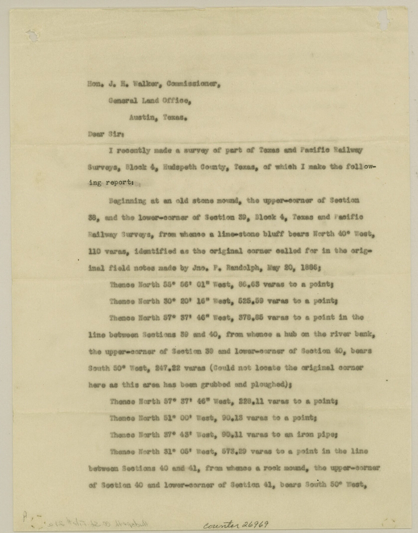
Hudspeth County Sketch File 21a
[Statement and connecting line by B. Estes]
-
Map/Doc
26969
-
Collection
General Map Collection
-
Object Dates
1/28/1935 (File Date)
-
People and Organizations
Bryan Estes (Surveyor/Engineer)
Jno. P. Randolph (Surveyor/Engineer)
-
Counties
Hudspeth
-
Subjects
Surveying Sketch File
-
Height x Width
10.6 x 8.4 inches
26.9 x 21.3 cm
-
Medium
paper, print
-
Features
Calamity Pass
Rio Grande
Quitman Mountains
Related maps
Hudspeth County Sketch File 21

Print $40.00
- Digital $50.00
Hudspeth County Sketch File 21
Size 60.1 x 38.0 inches
Map/Doc 10495
Part of: General Map Collection
List of surveys in Shelby County

List of surveys in Shelby County
1849
Size 13.2 x 8.2 inches
Map/Doc 62443
Liberty County Sketch File 10

Print $4.00
- Digital $50.00
Liberty County Sketch File 10
1858
Size 9.5 x 8.9 inches
Map/Doc 29903
Nueces County Rolled Sketch 19

Print $20.00
- Digital $50.00
Nueces County Rolled Sketch 19
1920
Size 22.5 x 32.7 inches
Map/Doc 6872
Henderson County Sketch File 23

Print $38.00
- Digital $50.00
Henderson County Sketch File 23
1956
Size 9.1 x 9.1 inches
Map/Doc 26372
Scurry County Rolled Sketch 5

Print $40.00
- Digital $50.00
Scurry County Rolled Sketch 5
Size 48.4 x 41.1 inches
Map/Doc 9913
Wichita County Rolled Sketch 19

Print $20.00
- Digital $50.00
Wichita County Rolled Sketch 19
1963
Size 28.5 x 30.9 inches
Map/Doc 8255
Val Verde County Sketch File Z8

Print $20.00
- Digital $50.00
Val Verde County Sketch File Z8
1884
Size 25.2 x 19.9 inches
Map/Doc 12553
[Sketch in DeWitt County]
![78383, [Sketch in DeWitt County], General Map Collection](https://historictexasmaps.com/wmedia_w700/maps/78383.tif.jpg)
Print $3.00
- Digital $50.00
[Sketch in DeWitt County]
Size 9.3 x 10.1 inches
Map/Doc 78383

Upton County Working Sketch 53

Print $20.00
- Digital $50.00
Upton County Working Sketch 53
1983
Size 26.8 x 31.2 inches
Map/Doc 69550
Roberts County Working Sketch 38

Print $20.00
- Digital $50.00
Roberts County Working Sketch 38
1978
Size 26.7 x 22.5 inches
Map/Doc 63564
Cooke County Sketch File 31

Print $22.00
- Digital $50.00
Cooke County Sketch File 31
1873
Size 8.0 x 12.9 inches
Map/Doc 19293
You may also like

Starr County Working Sketch 21

Print $20.00
- Digital $50.00
Starr County Working Sketch 21
1982
Size 32.6 x 33.7 inches
Map/Doc 63937
Lamb County Working Sketch 2

Print $20.00
- Digital $50.00
Lamb County Working Sketch 2
1919
Size 13.6 x 15.3 inches
Map/Doc 70275
Flight Mission No. BRE-1P, Frame 138, Nueces County

Print $20.00
- Digital $50.00
Flight Mission No. BRE-1P, Frame 138, Nueces County
1956
Size 18.4 x 22.3 inches
Map/Doc 86698
Corpus Christi Bay, Texas

Print $40.00
- Digital $50.00
Corpus Christi Bay, Texas
1867
Size 32.3 x 49.0 inches
Map/Doc 73469
Cochran County

Print $20.00
- Digital $50.00
Cochran County
1913
Size 29.1 x 20.0 inches
Map/Doc 4743
Flight Mission No. DQO-3K, Frame 27, Galveston County

Print $20.00
- Digital $50.00
Flight Mission No. DQO-3K, Frame 27, Galveston County
1952
Size 18.7 x 22.5 inches
Map/Doc 85068
Supreme Court of the United States, October Term, 1924, No. 13, Original - The State of Oklahoma, Complainant vs. The State of Texas, Defendant, The United States, Intervener

Print $20.00
- Digital $50.00
Supreme Court of the United States, October Term, 1924, No. 13, Original - The State of Oklahoma, Complainant vs. The State of Texas, Defendant, The United States, Intervener
1924
Size 22.1 x 38.7 inches
Map/Doc 75130
Moore County Rolled Sketch 4

Print $20.00
- Digital $50.00
Moore County Rolled Sketch 4
Size 21.1 x 12.1 inches
Map/Doc 6824
Limestone County Sketch File 27

Print $20.00
- Digital $50.00
Limestone County Sketch File 27
Size 23.2 x 18.8 inches
Map/Doc 12004
Flight Mission No. CRC-5R, Frame 41, Chambers County

Print $20.00
- Digital $50.00
Flight Mission No. CRC-5R, Frame 41, Chambers County
1956
Size 18.7 x 22.3 inches
Map/Doc 84960
The Great Lakes Region of the United States and Canada

The Great Lakes Region of the United States and Canada
1953
Size 42.5 x 28.6 inches
Map/Doc 92396