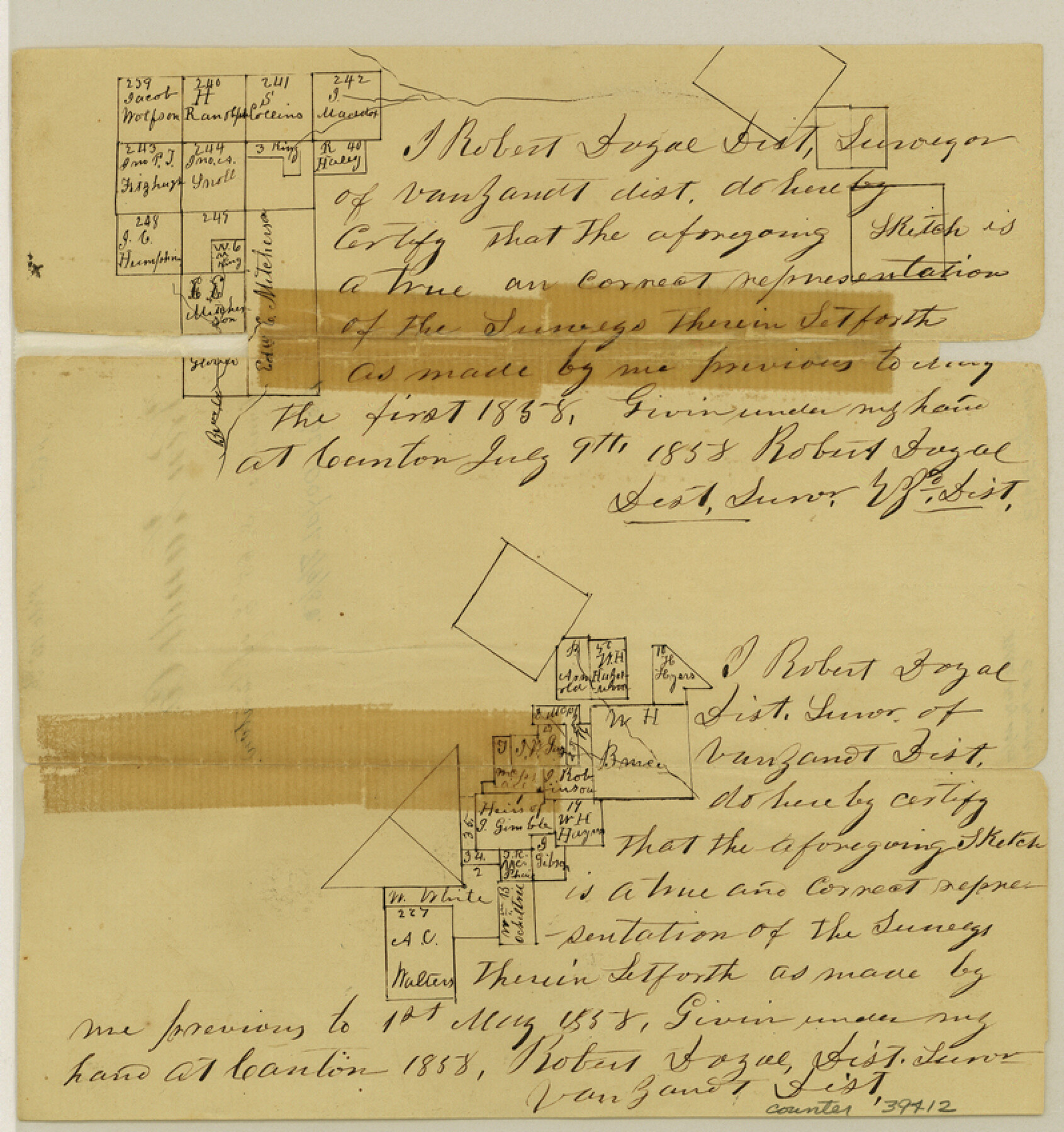
Van Zandt County Sketch File 16a
[Sketches of surveys southeast of Canton]
-
Map/Doc
39412
-
Collection
General Map Collection
-
Object Dates
7/9/1858 (Creation Date)
7/23/1858 (File Date)
-
People and Organizations
Robert Doyal (Surveyor/Engineer)
-
Counties
Van Zandt
-
Subjects
Surveying Sketch File
-
Height x Width
8.5 x 8.0 inches
21.6 x 20.3 cm
-
Medium
paper, manuscript
Part of: General Map Collection
Outer Continental Shelf Leasing Maps (Texas Offshore Operations)

Print $20.00
- Digital $50.00
Outer Continental Shelf Leasing Maps (Texas Offshore Operations)
Size 14.7 x 17.4 inches
Map/Doc 75845
A Geographically Correct Map of the State of Texas

Print $20.00
- Digital $50.00
A Geographically Correct Map of the State of Texas
1876
Size 20.4 x 21.9 inches
Map/Doc 95362
San Patricio County Aerial Photograph Index Sheet 4

Print $20.00
- Digital $50.00
San Patricio County Aerial Photograph Index Sheet 4
1957
Size 23.3 x 19.3 inches
Map/Doc 83746
Galveston County Rolled Sketch 17

Print $20.00
- Digital $50.00
Galveston County Rolled Sketch 17
1940
Size 40.4 x 35.4 inches
Map/Doc 9079
[Surveys made in Peters Colony by Dennis Corwin]
![1985, [Surveys made in Peters Colony by Dennis Corwin], General Map Collection](https://historictexasmaps.com/wmedia_w700/maps/1985.tif.jpg)
Print $20.00
- Digital $50.00
[Surveys made in Peters Colony by Dennis Corwin]
1859
Size 24.6 x 16.2 inches
Map/Doc 1985
Sabine County Boundary File 1

Print $96.00
- Digital $50.00
Sabine County Boundary File 1
Size 14.4 x 8.8 inches
Map/Doc 58530
Map of the Interior of Louisiana with a part of New Mexico

Print $20.00
- Digital $50.00
Map of the Interior of Louisiana with a part of New Mexico
1813
Size 11.9 x 15.7 inches
Map/Doc 94460
Pecos County Rolled Sketch 70

Print $40.00
- Digital $50.00
Pecos County Rolled Sketch 70
1929
Size 49.3 x 21.6 inches
Map/Doc 9708
Sectional Map No. 2 of the lands and the line of the Texas & Pacific Ry. Co. in Howard, Martin, Andrews, Midland and Tom Green Counties

Print $20.00
- Digital $50.00
Sectional Map No. 2 of the lands and the line of the Texas & Pacific Ry. Co. in Howard, Martin, Andrews, Midland and Tom Green Counties
1885
Size 19.1 x 23.3 inches
Map/Doc 4862
Loving County Rolled Sketch 3

Print $40.00
- Digital $50.00
Loving County Rolled Sketch 3
Size 13.9 x 145.3 inches
Map/Doc 9464
Grayson County Working Sketch 14

Print $20.00
- Digital $50.00
Grayson County Working Sketch 14
1952
Size 23.9 x 23.3 inches
Map/Doc 63253
Dawson County Working Sketch 2

Print $20.00
- Digital $50.00
Dawson County Working Sketch 2
1937
Size 8.8 x 20.3 inches
Map/Doc 68546
You may also like
Fort Bend County Rolled Sketch 16

Print $20.00
- Digital $50.00
Fort Bend County Rolled Sketch 16
1890
Size 29.3 x 26.5 inches
Map/Doc 5900
Flight Mission No. DAH-9M, Frame 160, Orange County

Print $20.00
- Digital $50.00
Flight Mission No. DAH-9M, Frame 160, Orange County
1953
Size 18.4 x 22.2 inches
Map/Doc 86859
Harbor Pass and Bar at Brazos Santiago, Texas

Print $20.00
- Digital $50.00
Harbor Pass and Bar at Brazos Santiago, Texas
1871
Size 18.2 x 26.8 inches
Map/Doc 72983

Kaufman County Boundary File 5

Print $37.00
- Digital $50.00
Kaufman County Boundary File 5
Size 13.4 x 8.7 inches
Map/Doc 55942
Crockett County Working Sketch 60

Print $20.00
- Digital $50.00
Crockett County Working Sketch 60
1955
Size 45.8 x 35.3 inches
Map/Doc 68393
[Surveys along Neils and Turkey Creeks]
![69761, [Surveys along Neils and Turkey Creeks], General Map Collection](https://historictexasmaps.com/wmedia_w700/maps/69761.tif.jpg)
Print $2.00
- Digital $50.00
[Surveys along Neils and Turkey Creeks]
1846
Size 10.8 x 7.9 inches
Map/Doc 69761
Hunt County Sketch File 34

Print $6.00
- Digital $50.00
Hunt County Sketch File 34
Size 9.9 x 7.2 inches
Map/Doc 27143
Cass County Working Sketch 38

Print $20.00
- Digital $50.00
Cass County Working Sketch 38
1982
Size 19.2 x 21.0 inches
Map/Doc 67941
Port Mansfield

Print $20.00
- Digital $50.00
Port Mansfield
1968
Size 37.1 x 44.2 inches
Map/Doc 3043
Webb County Working Sketch 58

Print $20.00
- Digital $50.00
Webb County Working Sketch 58
1958
Size 37.4 x 37.0 inches
Map/Doc 72424
El Paso County Working Sketch 37

Print $20.00
- Digital $50.00
El Paso County Working Sketch 37
1983
Size 28.2 x 24.8 inches
Map/Doc 69059