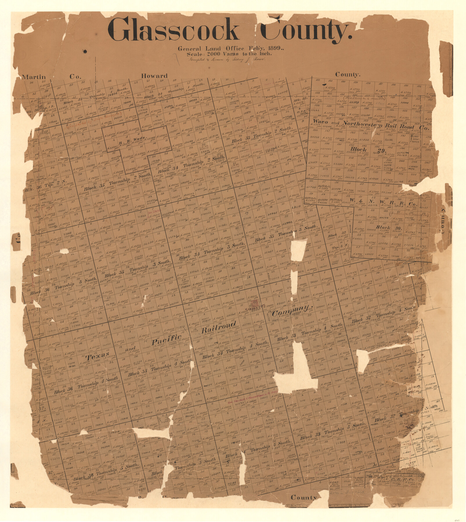
Glasscock County
-
Map/Doc
4707
-
Collection
General Map Collection
-
Object Dates
1899 (Creation Date)
-
People and Organizations
Texas General Land Office (Publisher)
Sidney J. Rowe (Compiler)
Sidney J. Rowe (Draftsman)
-
Counties
Glasscock
-
Subjects
County
-
Height x Width
38.1 x 33.9 inches
96.8 x 86.1 cm
-
Comments
Note on reverse side: "Retired March 3, 1933".
Help Save Texas History - Adopt Me! -
Features
Garden City
Part of: General Map Collection
Cooke County Working Sketch 28

Print $20.00
- Digital $50.00
Cooke County Working Sketch 28
1976
Size 28.4 x 34.1 inches
Map/Doc 68265
San Jacinto County Working Sketch 13

Print $20.00
- Digital $50.00
San Jacinto County Working Sketch 13
1935
Size 25.0 x 18.8 inches
Map/Doc 63726
Upton County Sketch File 37

Print $6.00
- Digital $50.00
Upton County Sketch File 37
1953
Size 11.3 x 8.8 inches
Map/Doc 38900
Garza County Sketch File 30

Print $8.00
- Digital $50.00
Garza County Sketch File 30
1959
Size 14.3 x 8.8 inches
Map/Doc 24100
[Fragment, Jefferson Plotted]
![78352, [Fragment, Jefferson Plotted], General Map Collection](https://historictexasmaps.com/wmedia_w700/maps/78352.tif.jpg)
Print $2.00
- Digital $50.00
[Fragment, Jefferson Plotted]
Size 14.0 x 7.5 inches
Map/Doc 78352
Newton County Rolled Sketch 4

Print $20.00
- Digital $50.00
Newton County Rolled Sketch 4
1893
Size 21.1 x 19.7 inches
Map/Doc 6840
Map of Madison County

Print $20.00
- Digital $50.00
Map of Madison County
1858
Size 19.8 x 31.7 inches
Map/Doc 3834
Calhoun County NRC Article 33.136 Sketch 11

Digital $50.00
Calhoun County NRC Article 33.136 Sketch 11
2023
Map/Doc 97255
Jim Hogg County Rolled Sketch 14

Print $20.00
- Digital $50.00
Jim Hogg County Rolled Sketch 14
2023
Size 21.1 x 30.3 inches
Map/Doc 97155
Jefferson County Sketch File 19

Print $20.00
- Digital $50.00
Jefferson County Sketch File 19
1872
Size 15.0 x 20.1 inches
Map/Doc 11870
Cass County Working Sketch 34

Print $20.00
- Digital $50.00
Cass County Working Sketch 34
1982
Size 21.1 x 24.6 inches
Map/Doc 67937
Tom Green County Sketch File 75

Print $20.00
- Digital $50.00
Tom Green County Sketch File 75
1950
Size 18.1 x 22.5 inches
Map/Doc 12449
You may also like
Aransas County Working Sketch 16

Print $40.00
- Digital $50.00
Aransas County Working Sketch 16
1965
Size 55.3 x 43.1 inches
Map/Doc 67183
Eastland County Working Sketch 36

Print $20.00
- Digital $50.00
Eastland County Working Sketch 36
1963
Size 24.0 x 40.0 inches
Map/Doc 68817
[Map of the Texas & Pacific Railway and connections]
![95414, [Map of the Texas & Pacific Railway and connections], Holcomb Digital Map Collection](https://historictexasmaps.com/wmedia_w700/maps/95414.tif.jpg)
Print $20.00
- Digital $50.00
[Map of the Texas & Pacific Railway and connections]
1902
Size 18.0 x 37.0 inches
Map/Doc 95414
Hutchinson County Sketch File 43

Print $4.00
- Digital $50.00
Hutchinson County Sketch File 43
1891
Size 11.2 x 8.8 inches
Map/Doc 27309
Missouri, Kansas, & Texas Ry.

Print $20.00
- Digital $50.00
Missouri, Kansas, & Texas Ry.
Size 6.7 x 5.4 inches
Map/Doc 96598
Carta General de la República Mexicana formada por Antonio García y Cubas

Print $40.00
Carta General de la República Mexicana formada por Antonio García y Cubas
1863
Size 48.7 x 57.1 inches
Map/Doc 95307
Stephens County Working Sketch 10

Print $40.00
- Digital $50.00
Stephens County Working Sketch 10
1921
Size 36.1 x 64.1 inches
Map/Doc 63953
W. D. McMillan Estate

Print $20.00
- Digital $50.00
W. D. McMillan Estate
1951
Size 18.0 x 23.1 inches
Map/Doc 92730
Wharton County

Print $40.00
- Digital $50.00
Wharton County
1946
Size 43.0 x 49.2 inches
Map/Doc 73321
Outer Continental Shelf Leasing Maps (Texas Offshore Operations)

Print $20.00
- Digital $50.00
Outer Continental Shelf Leasing Maps (Texas Offshore Operations)
Size 17.6 x 13.6 inches
Map/Doc 75850
[Gunter & Munson and Surrounding Surveys]
![91238, [Gunter & Munson and Surrounding Surveys], Twichell Survey Records](https://historictexasmaps.com/wmedia_w700/maps/91238-1.tif.jpg)
Print $20.00
- Digital $50.00
[Gunter & Munson and Surrounding Surveys]
Size 16.3 x 21.4 inches
Map/Doc 91238
Hunt County Working Sketch 11

Print $20.00
- Digital $50.00
Hunt County Working Sketch 11
2002
Size 32.1 x 29.6 inches
Map/Doc 66358