Hall County Rolled Sketch 5
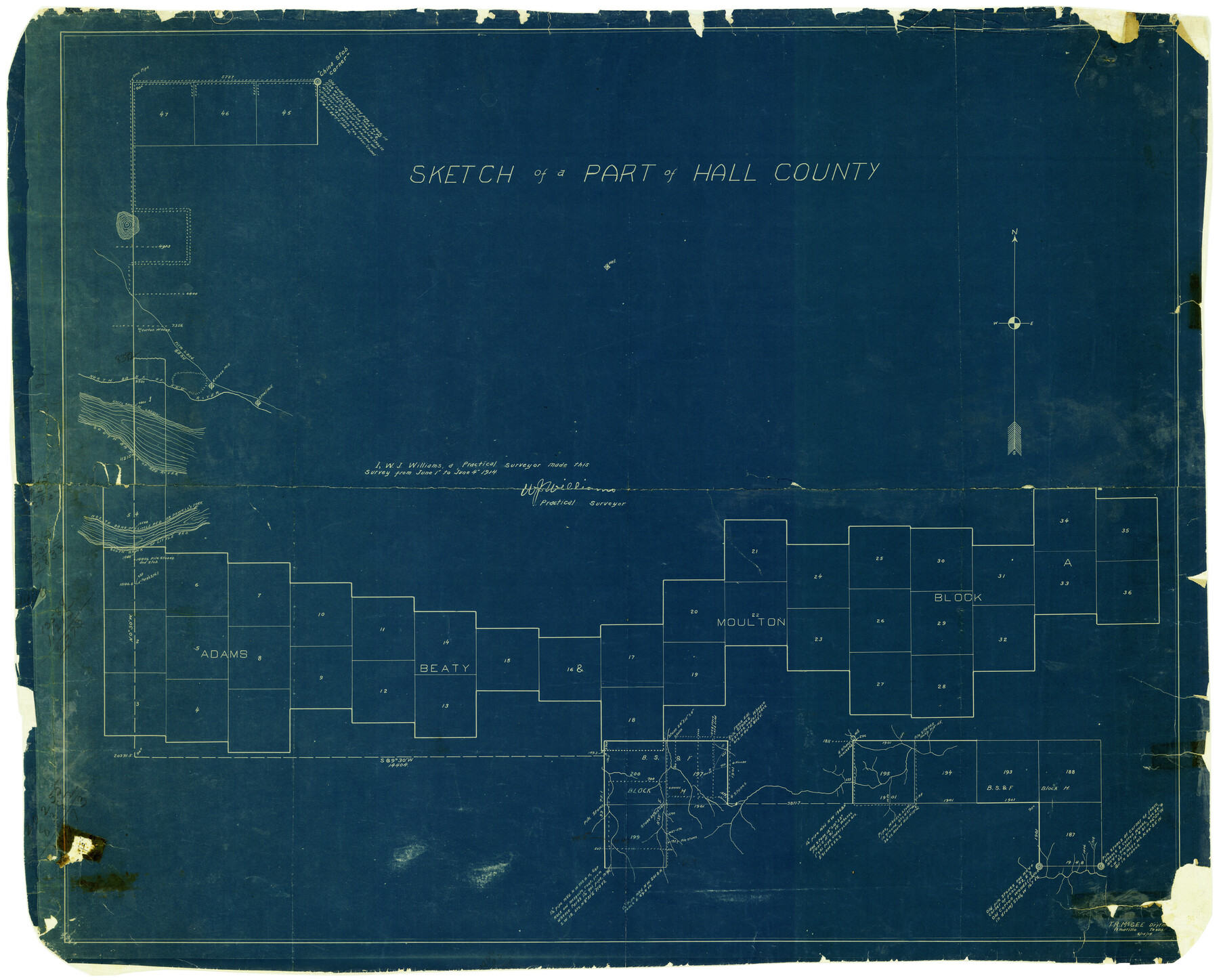
Sketch of Part of Hall County
-
Map/Doc
6049
-
Collection
General Map Collection
-
Object Dates
6/4/1914 (Creation Date)
-
People and Organizations
W.J. Williams (Surveyor/Engineer)
-
Counties
Hall
-
Subjects
Surveying Rolled Sketch
-
Height x Width
30.2 x 37.1 inches
76.7 x 94.2 cm
-
Medium
blueprint/diazo
Part of: General Map Collection
Upton County Sketch File 13

Print $20.00
- Digital $50.00
Upton County Sketch File 13
1926
Size 34.3 x 37.3 inches
Map/Doc 10414
Hutchinson County Sketch File 9

Print $4.00
- Digital $50.00
Hutchinson County Sketch File 9
1900
Size 12.7 x 9.2 inches
Map/Doc 27209
[Gulf Coast of Texas]
![72704, [Gulf Coast of Texas], General Map Collection](https://historictexasmaps.com/wmedia_w700/maps/72704.tif.jpg)
Print $20.00
- Digital $50.00
[Gulf Coast of Texas]
1881
Size 28.7 x 18.2 inches
Map/Doc 72704
University Lands Blocks 21 to 26, Pecos County, Texas

Print $20.00
- Digital $50.00
University Lands Blocks 21 to 26, Pecos County, Texas
1939
Size 46.1 x 36.8 inches
Map/Doc 2416
Nueces County Sketch File 42

Print $24.00
- Digital $50.00
Nueces County Sketch File 42
1950
Size 11.0 x 8.6 inches
Map/Doc 32633
Polk County Sketch File 45

Print $4.00
- Digital $50.00
Polk County Sketch File 45
Size 11.3 x 8.8 inches
Map/Doc 34376
University Lands, Blocks 1-13 & Block 58, Crockett, Reagan & Upton Counties

Print $20.00
- Digital $50.00
University Lands, Blocks 1-13 & Block 58, Crockett, Reagan & Upton Counties
1936
Size 36.9 x 42.0 inches
Map/Doc 2409
Map showing the environs of Brazos Islnd. Texas

Print $20.00
- Digital $50.00
Map showing the environs of Brazos Islnd. Texas
1864
Size 26.2 x 18.2 inches
Map/Doc 72914
Cameron County Rolled Sketch 20E

Print $20.00
- Digital $50.00
Cameron County Rolled Sketch 20E
Size 13.0 x 12.5 inches
Map/Doc 5478
Bee County Boundary File 4

Print $22.00
- Digital $50.00
Bee County Boundary File 4
Size 12.9 x 8.1 inches
Map/Doc 50441
Flight Mission No. DQN-1K, Frame 135, Calhoun County

Print $20.00
- Digital $50.00
Flight Mission No. DQN-1K, Frame 135, Calhoun County
1953
Size 18.3 x 22.4 inches
Map/Doc 84198
Gaines County Rolled Sketch 17A

Print $40.00
- Digital $50.00
Gaines County Rolled Sketch 17A
1950
Size 23.9 x 61.6 inches
Map/Doc 9040
You may also like
Right of Way and Track Map Houston & Texas Central R.R. operated by the T. & N.O. R.R. Co., Austin Branch

Print $40.00
- Digital $50.00
Right of Way and Track Map Houston & Texas Central R.R. operated by the T. & N.O. R.R. Co., Austin Branch
1918
Size 26.0 x 58.4 inches
Map/Doc 64556
Crockett County Working Sketch 87

Print $20.00
- Digital $50.00
Crockett County Working Sketch 87
1976
Size 35.5 x 43.8 inches
Map/Doc 68420
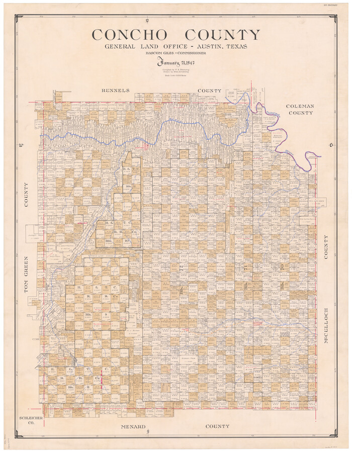
Concho County
Print $20.00
- Digital $50.00
Concho County
1947
Size 46.8 x 36.9 inches
Map/Doc 73115
Polk County Sketch File 12

Print $4.00
- Digital $50.00
Polk County Sketch File 12
Size 9.0 x 5.8 inches
Map/Doc 34146
Lynn County Sketch File 14

Print $12.00
- Digital $50.00
Lynn County Sketch File 14
1916
Size 14.1 x 8.7 inches
Map/Doc 30491
Andrews County Sketch File 12

Print $8.00
- Digital $50.00
Andrews County Sketch File 12
1963
Size 11.1 x 8.5 inches
Map/Doc 12857
Live Oak County Working Sketch 8

Print $20.00
- Digital $50.00
Live Oak County Working Sketch 8
1937
Size 11.1 x 13.3 inches
Map/Doc 70593
Kendall County

Print $20.00
- Digital $50.00
Kendall County
1946
Size 42.5 x 36.8 inches
Map/Doc 95553
Webb County Sketch File 44b-1

Print $20.00
- Digital $50.00
Webb County Sketch File 44b-1
1936
Size 29.0 x 18.0 inches
Map/Doc 12641
[Sketch showing Capitol Lands]
![89725, [Sketch showing Capitol Lands], Twichell Survey Records](https://historictexasmaps.com/wmedia_w700/maps/89725-1.tif.jpg)
Print $40.00
- Digital $50.00
[Sketch showing Capitol Lands]
Size 38.3 x 72.0 inches
Map/Doc 89725
Texas Coordinate File 3

Print $40.00
- Digital $50.00
Texas Coordinate File 3
Size 36.1 x 49.1 inches
Map/Doc 75306
Flight Mission No. DQO-8K, Frame 55, Galveston County

Print $20.00
- Digital $50.00
Flight Mission No. DQO-8K, Frame 55, Galveston County
1952
Size 18.7 x 22.5 inches
Map/Doc 85162