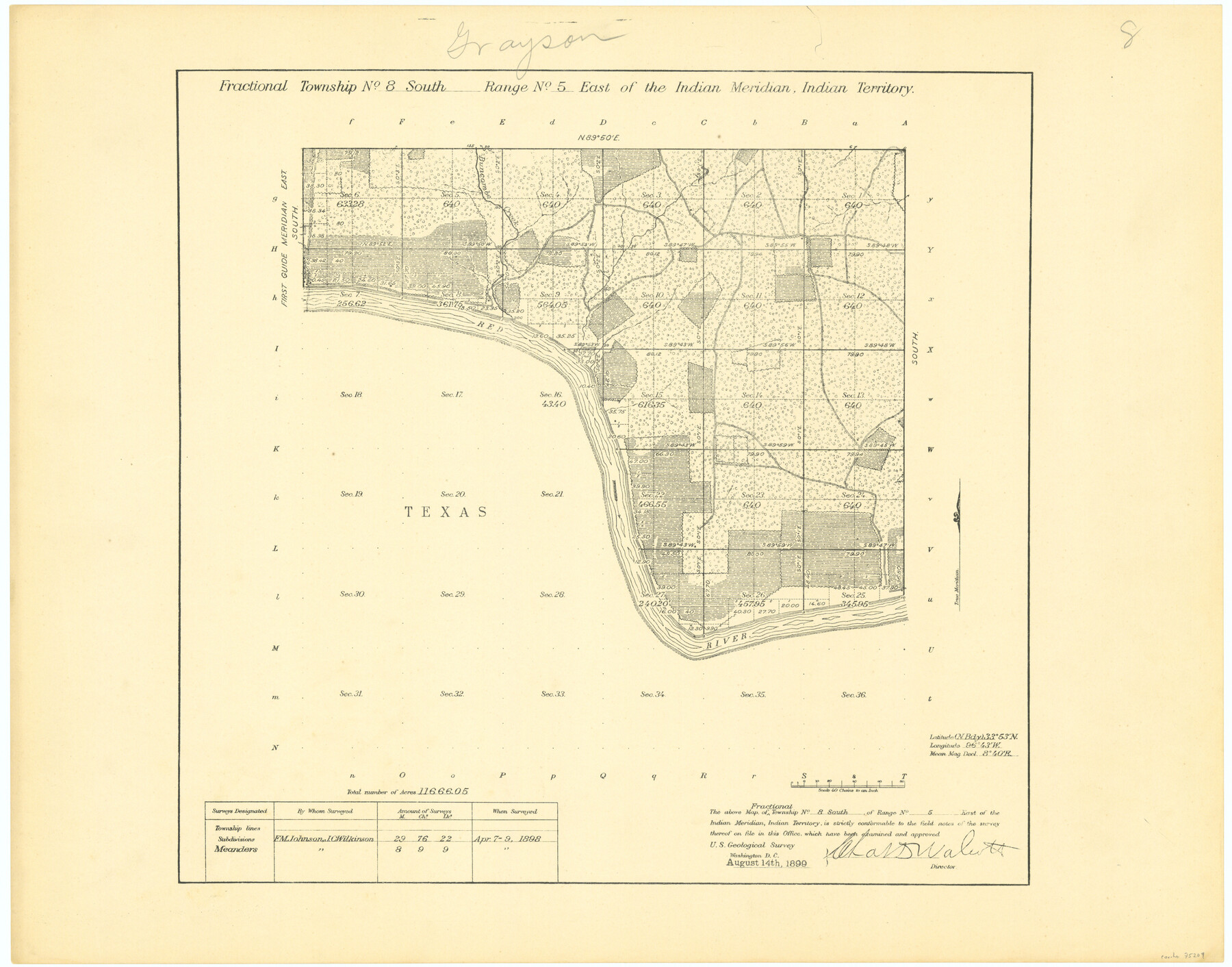
Fractional Township No. 8 South Range No. 5 East of the Indian Meridian, Indian Territory
-
Map/Doc
75209
-
Collection
General Map Collection
-
Object Dates
1898/4/9 (Creation Date)
-
Subjects
Texas Boundaries
-
Height x Width
19.2 x 24.4 inches
48.8 x 62.0 cm
Part of: General Map Collection
Flight Mission No. CGI-1N, Frame 215, Cameron County

Print $20.00
- Digital $50.00
Flight Mission No. CGI-1N, Frame 215, Cameron County
1955
Size 18.5 x 22.1 inches
Map/Doc 84524
Flight Mission No. DCL-4C, Frame 64, Kenedy County

Print $20.00
- Digital $50.00
Flight Mission No. DCL-4C, Frame 64, Kenedy County
1943
Size 18.6 x 22.4 inches
Map/Doc 85809
Ector County Working Sketch 7

Print $40.00
- Digital $50.00
Ector County Working Sketch 7
1941
Size 48.5 x 29.3 inches
Map/Doc 68850
Travis County Working Sketch 39

Print $20.00
- Digital $50.00
Travis County Working Sketch 39
1974
Size 33.1 x 31.7 inches
Map/Doc 69423
Flight Mission No. DAG-24K, Frame 135, Matagorda County

Print $20.00
- Digital $50.00
Flight Mission No. DAG-24K, Frame 135, Matagorda County
1953
Size 18.4 x 22.2 inches
Map/Doc 86553
Terry County Sketch File 17

Print $5.00
- Digital $50.00
Terry County Sketch File 17
1956
Size 27.7 x 24.7 inches
Map/Doc 12429

Val Verde County Sketch File H

Print $14.00
- Digital $50.00
Val Verde County Sketch File H
1891
Size 8.9 x 6.9 inches
Map/Doc 39291
Survey of The Rio Grande Roma to the Gulf of Mexico

Survey of The Rio Grande Roma to the Gulf of Mexico
Map/Doc 81739
Wharton County Sketch File 17

Print $12.00
- Digital $50.00
Wharton County Sketch File 17
1898
Size 12.8 x 8.1 inches
Map/Doc 39969
Galveston County NRC Article 33.136 Sketch 23

Print $22.00
- Digital $50.00
Galveston County NRC Article 33.136 Sketch 23
2002
Size 11.4 x 16.4 inches
Map/Doc 81905
Flight Mission No. DQO-7K, Frame 101, Galveston County

Print $20.00
- Digital $50.00
Flight Mission No. DQO-7K, Frame 101, Galveston County
1952
Size 18.7 x 22.6 inches
Map/Doc 85116
You may also like
Smith County Sketch File 7

Print $4.00
- Digital $50.00
Smith County Sketch File 7
1848
Size 12.7 x 8.2 inches
Map/Doc 36759
Map of Jack County

Print $20.00
- Digital $50.00
Map of Jack County
Size 18.4 x 15.9 inches
Map/Doc 3702
Flight Mission No. CON-2R, Frame 55, Stonewall County

Print $20.00
- Digital $50.00
Flight Mission No. CON-2R, Frame 55, Stonewall County
1957
Size 18.3 x 22.0 inches
Map/Doc 86987
Sulphur River, North Extension, Turner Lake Sheet

Print $4.00
- Digital $50.00
Sulphur River, North Extension, Turner Lake Sheet
1922
Size 17.8 x 18.6 inches
Map/Doc 65158
Map of Matagorda County

Print $20.00
- Digital $50.00
Map of Matagorda County
1865
Size 32.8 x 28.4 inches
Map/Doc 3843
Clay County Sketch File 14

Print $40.00
- Digital $50.00
Clay County Sketch File 14
1873
Size 16.5 x 13.8 inches
Map/Doc 18417
San Patricio County Working Sketch 12

Print $40.00
- Digital $50.00
San Patricio County Working Sketch 12
Size 51.4 x 40.7 inches
Map/Doc 63774
Layout of the porciones as described in the Visita General of Mier, 1767

Layout of the porciones as described in the Visita General of Mier, 1767
2009
Size 11.0 x 8.5 inches
Map/Doc 94043
Bastrop County

Print $40.00
- Digital $50.00
Bastrop County
1917
Size 48.0 x 40.5 inches
Map/Doc 4881
[King, Knox & Stonewall Counties]
![92917, [King, Knox & Stonewall Counties], Twichell Survey Records](https://historictexasmaps.com/wmedia_w700/maps/92917-1.tif.jpg)
Print $20.00
- Digital $50.00
[King, Knox & Stonewall Counties]
1902
Size 19.6 x 28.2 inches
Map/Doc 92917
New Hobbs, Lea County, New Mexico

Print $20.00
- Digital $50.00
New Hobbs, Lea County, New Mexico
Size 15.7 x 20.1 inches
Map/Doc 92424
Lubbock County Working Sketch 6

Print $20.00
- Digital $50.00
Lubbock County Working Sketch 6
1959
Size 25.1 x 22.4 inches
Map/Doc 70666