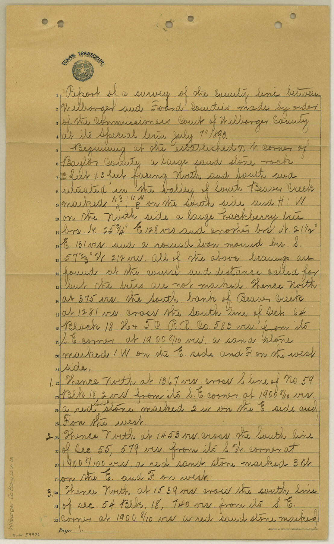
Wilbarger County Boundary File 1a
Field Notes and Plat of a survey of County line between Wilbarger and Foard Counties
-
Map/Doc
59936
-
Collection
General Map Collection
-
Counties
Wilbarger
-
Subjects
County Boundaries
-
Height x Width
14.2 x 8.7 inches
36.1 x 22.1 cm
Part of: General Map Collection
Carte du Texas, Extraite de la grande Carte du Mexique par A. Brué Géographe du Roi, Revue, corrigée et considerablement augmentée d'après des documens récens et renseignemens fournis par Mr. le Docteur Fc. Leclerc

Print $20.00
- Digital $50.00
Carte du Texas, Extraite de la grande Carte du Mexique par A. Brué Géographe du Roi, Revue, corrigée et considerablement augmentée d'après des documens récens et renseignemens fournis par Mr. le Docteur Fc. Leclerc
1840
Size 12.6 x 14.2 inches
Map/Doc 94273
Presidio County Rolled Sketch 104

Print $20.00
- Digital $50.00
Presidio County Rolled Sketch 104
1948
Size 26.1 x 40.0 inches
Map/Doc 7386
Throckmorton Co.

Print $20.00
- Digital $50.00
Throckmorton Co.
1898
Size 41.2 x 35.9 inches
Map/Doc 16895
Moore County Working Sketch 8

Print $20.00
- Digital $50.00
Moore County Working Sketch 8
1948
Size 23.2 x 31.8 inches
Map/Doc 71190
Bosque County Working Sketch 7

Print $20.00
- Digital $50.00
Bosque County Working Sketch 7
1942
Size 23.7 x 34.5 inches
Map/Doc 67440
Chambers County Rolled Sketch 11

Print $20.00
- Digital $50.00
Chambers County Rolled Sketch 11
Size 20.0 x 26.5 inches
Map/Doc 5424
Jack County Working Sketch 17

Print $20.00
- Digital $50.00
Jack County Working Sketch 17
1982
Size 25.9 x 27.4 inches
Map/Doc 66443
[Surveys in the Bexar District along the Medina River]
![130, [Surveys in the Bexar District along the Medina River], General Map Collection](https://historictexasmaps.com/wmedia_w700/maps/130.tif.jpg)
Print $20.00
- Digital $50.00
[Surveys in the Bexar District along the Medina River]
1841
Size 20.7 x 12.8 inches
Map/Doc 130
Crockett County Rolled Sketch 90

Print $20.00
- Digital $50.00
Crockett County Rolled Sketch 90
1975
Size 25.4 x 37.3 inches
Map/Doc 5631
[G. C. & S. F. Ry. Alinement (sic) and Right of Way Map of Dallas Branch, Johnson County, Texas]
![64651, [G. C. & S. F. Ry. Alinement (sic) and Right of Way Map of Dallas Branch, Johnson County, Texas], General Map Collection](https://historictexasmaps.com/wmedia_w700/maps/64651.tif.jpg)
Print $40.00
- Digital $50.00
[G. C. & S. F. Ry. Alinement (sic) and Right of Way Map of Dallas Branch, Johnson County, Texas]
1926
Size 37.6 x 124.3 inches
Map/Doc 64651
Tyler County Sketch File 2

Print $4.00
- Digital $50.00
Tyler County Sketch File 2
Size 6.3 x 5.6 inches
Map/Doc 38615
Houston County Sketch File 5

Print $4.00
- Digital $50.00
Houston County Sketch File 5
1860
Size 8.5 x 12.7 inches
Map/Doc 26757
You may also like
[North line of T. C. RR. Blk on North County Line]
![90516, [North line of T. C. RR. Blk on North County Line], Twichell Survey Records](https://historictexasmaps.com/wmedia_w700/maps/90516-1.tif.jpg)
Print $2.00
- Digital $50.00
[North line of T. C. RR. Blk on North County Line]
Size 13.7 x 5.1 inches
Map/Doc 90516
Archer County Rolled Sketch B2

Print $20.00
- Digital $50.00
Archer County Rolled Sketch B2
1891
Size 36.7 x 30.7 inches
Map/Doc 5105
Maps & Lists Showing Prison Lands (Oil & Gas) Leased as of June 1955

Digital $50.00
Maps & Lists Showing Prison Lands (Oil & Gas) Leased as of June 1955
Size 11.4 x 7.0 inches
Map/Doc 62864
Crockett County Sketch File 72

Print $14.00
- Digital $50.00
Crockett County Sketch File 72
Size 14.0 x 8.6 inches
Map/Doc 19862
Lubbock County Sketch File 6

Print $20.00
- Digital $50.00
Lubbock County Sketch File 6
1902
Size 33.0 x 20.8 inches
Map/Doc 12017
Hays County Sketch File 19

Print $6.00
- Digital $50.00
Hays County Sketch File 19
Size 8.5 x 6.7 inches
Map/Doc 26237
Greer County Sketch File 3

Print $20.00
- Digital $50.00
Greer County Sketch File 3
Size 20.1 x 18.2 inches
Map/Doc 11583
Map of Hamilton County

Print $20.00
- Digital $50.00
Map of Hamilton County
1872
Size 15.1 x 22.1 inches
Map/Doc 4555
McLennan County Working Sketch 9

Print $20.00
- Digital $50.00
McLennan County Working Sketch 9
2008
Size 23.0 x 28.9 inches
Map/Doc 88768
Callahan County Rolled Sketch 26

Print $20.00
- Digital $50.00
Callahan County Rolled Sketch 26
2010
Size 30.6 x 24.6 inches
Map/Doc 93453

Chambers County Sketch File 48

Print $88.00
- Digital $50.00
Chambers County Sketch File 48
1925
Size 14.3 x 8.8 inches
Map/Doc 18002