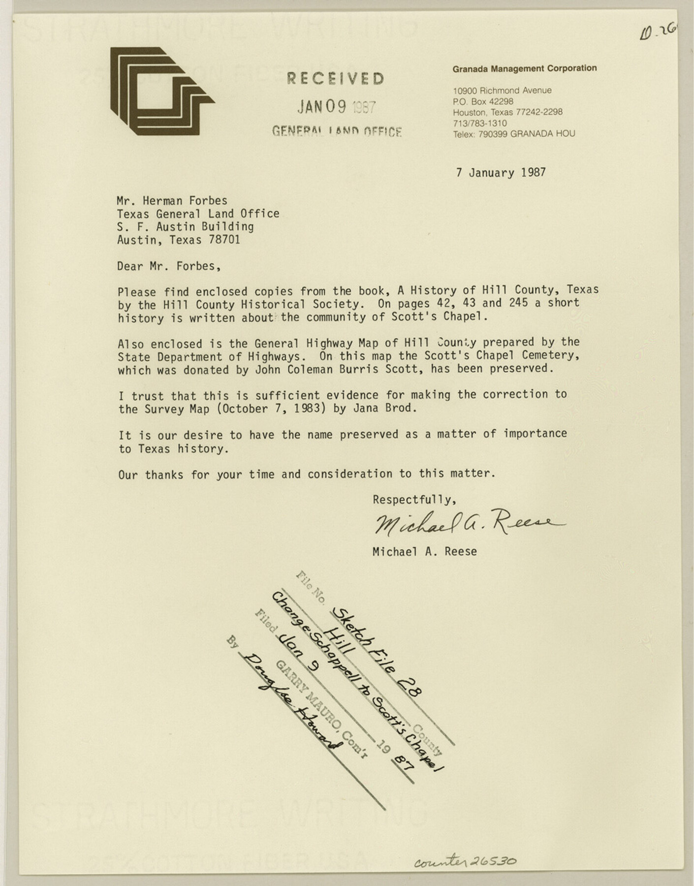
Hill County Sketch file 28
Change Schappell to Scott's Chapel
-
Map/Doc
26530
-
Collection
General Map Collection
-
Object Dates
1/7/1987 (Creation Date)
1/9/1987 (File Date)
1/7/1987 (Correspondence Date)
-
People and Organizations
Michael Reese (Author)
-
Counties
Hill Navarro Bosque
-
Subjects
Surveying Sketch File
-
Height x Width
11.3 x 8.9 inches
28.7 x 22.6 cm
-
Medium
paper, print
-
Features
FM 1304
Menlow
Scott's Chapel School
Itasca
Steiner Valley Cemetery
Stembridge Cemetery
Burris Cemetery
Rienzi Cemetery
Zollicoffer Cemetery
Walling Family Cemetery
Eureka Cemetery
Copperhead Cemetery
Simons Cemetery
Abbott Cemetery
Jessie-Chatt Cemetery
Rockwall Cemetery
Latham Springs
Offield Springs
Highway 933
Whitney
Prairie Grove Cemetey
Allen Bend Cemetery
Cedron Creek Cemetery
Powell Cemetery
Pogue Cemetery
Kimball Bend Cemetery
Kimball Cemetery
Brazos River
Beasley Cemetery
Fort Graham South Cemetery
Fort Graham West Cemetery
MK&T
Treadwell
Schappell
Road to Meridian
AT&SF
Blum
Adair Spring Park
Road to Cleburne
Mustang Creek
Falls Branch of Brazos River
Gourd Neck Creek
Flynns Ranch
Ross
Covington
Gathings
Woodrow
Union Hill
Island Creek
Osceola
Hayden Creek
Itasco Creek
Majors Branch of Hayden Creek
Irene
Road to Maypearl
Presbyterian Childrens Home
Reece Ranch
Coleman Creek
Walker Creek
Cottonwood Creek
Iverson Community
Files Valley Community
Files
Hockberry Creek
Bois d'Arc
Mayfield
Shiloh
Aquitta Creek
RR 3049
FM 934
FM 309
Huron Community
Hix
Blanton Community
Bear Creek
Little Bear Creek
Benson Slough
Kopperl
FM 1713
Whitney
Lake Whitney State Park
Lake Whitney
Frazier Creek
Whitney Creek
Allison
Hillsboro
Mackey
Woodbury
Peoria
Coleman Creek
Lovelace Creek
Carl's Corner
Parker Creek
Hackberry Creek
Jack's Creek
Love View
Midway Community
Richland Creek
Brandon
Road to Dallas
Road to Waxahachie
White Rock Creek
Pecan Creek
Hillsboro Municipal Airport
Pecan
Hillcrest
Little Hackberry Creek
Yates
Rocky Creek
Allison
Oak Grove
Woodland Hills
Whiterock
Road to Valley Mills
Odom
Vaughan
Vaughan Community
Towash Creek
Two Mile Creek
Frazier
Bynum
Lakenon
Grove Creek
FM 3267
Bynum Brandon
Old Brandon
Mertens
Road to Milford
Road to Corsicana
RR 22
Salem
Road to Emmett
Massey Community
Four Mile Creek
Bynum Creek
Walling
Bell Springs
Abbott
Fatima
Cobb Creek
County Line Road
Menlow Community
Alligator Creek
Tyson Community
Lebanon
Prairie Grove
FM 1304
Snake Creek
Road to Bellmead
Road to West
Brookeen Creek
Ash Creek
Brushy Creek
Burross
Malone
St. Peter's
Road to Emmett
Navarro Mills Reservoir
McLain
Road to Corsicana
Little Cottonwood Creek
Penelope
St. Joseph
Tabola
Hubbard Lakes
Valley View
Battle Creek
Hubbard
Mount Calm
Horn Creek
Pin Oak Creek
Mesquite
Tehuacana Creek
Mesquite Creek
Wolf Creek
Crooked Creek
Road to Waco
McHill
SLS
Road to Prairie Hill
FM 339
Navasota River
Turkey Creek
Grays Branch
Jackson Creek
Road to Coolidge
Part of: General Map Collection
Camp County Working Sketch 3

Print $20.00
- Digital $50.00
Camp County Working Sketch 3
1982
Size 32.1 x 24.4 inches
Map/Doc 67879
Galveston County Sketch File 70

Print $26.00
- Digital $50.00
Galveston County Sketch File 70
1983
Size 11.3 x 8.7 inches
Map/Doc 23928
Duval County Sketch File 19b

Print $6.00
- Digital $50.00
Duval County Sketch File 19b
Size 15.4 x 9.7 inches
Map/Doc 21320
Newton County Sketch File 4b

Print $22.00
- Digital $50.00
Newton County Sketch File 4b
Size 7.6 x 12.2 inches
Map/Doc 32364
Starr County Sketch File 42

Print $20.00
- Digital $50.00
Starr County Sketch File 42
1941
Size 19.0 x 21.6 inches
Map/Doc 12341

Lamar County Sketch File 13

Print $2.00
- Digital $50.00
Lamar County Sketch File 13
1943
Size 10.9 x 8.0 inches
Map/Doc 29307

[Surveys between the Caddo River and south fork of the Sabine River]
![280, [Surveys between the Caddo River and south fork of the Sabine River], General Map Collection](https://historictexasmaps.com/wmedia_w700/maps/280.tif.jpg)
Print $2.00
- Digital $50.00
[Surveys between the Caddo River and south fork of the Sabine River]
Size 7.8 x 6.5 inches
Map/Doc 280
Taylor County Sketch File 10

Print $20.00
- Digital $50.00
Taylor County Sketch File 10
Size 35.2 x 34.4 inches
Map/Doc 10383
Brazos River, Howth Sheet

Print $6.00
- Digital $50.00
Brazos River, Howth Sheet
1936
Size 30.5 x 30.9 inches
Map/Doc 65276
[Traverse up the Brazos and Colorado River showing distance from county site to county site]
![2054, [Traverse up the Brazos and Colorado River showing distance from county site to county site], General Map Collection](https://historictexasmaps.com/wmedia_w700/maps/2054.tif.jpg)
Print $40.00
- Digital $50.00
[Traverse up the Brazos and Colorado River showing distance from county site to county site]
1871
Size 16.2 x 98.8 inches
Map/Doc 2054
You may also like
Copy of Surveyor's Field Book, Morris Browning - In Blocks 7, 5 & 4, I&GNRRCo., Hutchinson and Carson Counties, Texas

Print $2.00
- Digital $50.00
Copy of Surveyor's Field Book, Morris Browning - In Blocks 7, 5 & 4, I&GNRRCo., Hutchinson and Carson Counties, Texas
1888
Size 7.0 x 8.8 inches
Map/Doc 62279
[H. P. Fleming, J. E. Fitzgerald, J. R. Scott and surrounding surveys]
![90954, [H. P. Fleming, J. E. Fitzgerald, J. R. Scott and surrounding surveys], Twichell Survey Records](https://historictexasmaps.com/wmedia_w700/maps/90954-1.tif.jpg)
Print $20.00
- Digital $50.00
[H. P. Fleming, J. E. Fitzgerald, J. R. Scott and surrounding surveys]
Size 19.7 x 12.9 inches
Map/Doc 90954
Yoakum County Rolled Sketch 3(2)

Print $40.00
- Digital $50.00
Yoakum County Rolled Sketch 3(2)
1959
Size 12.4 x 104.3 inches
Map/Doc 76041
The Military History of Texas Map!

The Military History of Texas Map!
1996
Size 24.2 x 35.0 inches
Map/Doc 96828
Nolan County Rolled Sketch 2A

Print $20.00
- Digital $50.00
Nolan County Rolled Sketch 2A
Size 26.9 x 34.8 inches
Map/Doc 6861
[Sketch showing B. S. & F. survey 9, sections 162, 163, 178, 179 in town of Bush]
![91728, [Sketch showing B. S. & F. survey 9, sections 162, 163, 178, 179 in town of Bush], Twichell Survey Records](https://historictexasmaps.com/wmedia_w700/maps/91728-1.tif.jpg)
Print $20.00
- Digital $50.00
[Sketch showing B. S. & F. survey 9, sections 162, 163, 178, 179 in town of Bush]
Size 12.0 x 16.1 inches
Map/Doc 91728
[Area around Lee County School Land Leagues]
![90804, [Area around Lee County School Land Leagues], Twichell Survey Records](https://historictexasmaps.com/wmedia_w700/maps/90804-1.tif.jpg)
Print $3.00
- Digital $50.00
[Area around Lee County School Land Leagues]
Size 9.7 x 15.2 inches
Map/Doc 90804
Ellis County Working Sketch 4

Print $40.00
- Digital $50.00
Ellis County Working Sketch 4
1997
Size 48.0 x 30.3 inches
Map/Doc 69020
Southern Pacific Rice Belt

Print $40.00
- Digital $50.00
Southern Pacific Rice Belt
Size 31.6 x 57.9 inches
Map/Doc 96793
Nueces County Sketch File 32

Print $32.00
- Digital $50.00
Nueces County Sketch File 32
1907
Size 14.2 x 8.7 inches
Map/Doc 32605
Matagorda County Working Sketch 21

Print $20.00
- Digital $50.00
Matagorda County Working Sketch 21
1966
Size 35.5 x 41.2 inches
Map/Doc 70879
Jones County Working Sketch 8

Print $20.00
- Digital $50.00
Jones County Working Sketch 8
1979
Size 25.3 x 20.9 inches
Map/Doc 66646