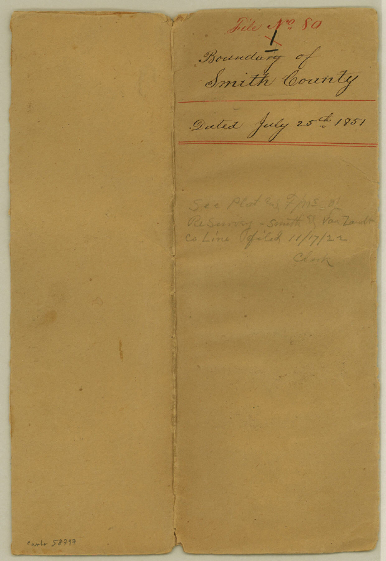
Smith County Boundary File 80
Boundary of Smith County
-
Map/Doc
58797
-
Collection
General Map Collection
-
Counties
Smith
-
Subjects
County Boundaries
-
Height x Width
9.0 x 6.2 inches
22.9 x 15.7 cm
Part of: General Map Collection
Brewster County Sketch File FN-32

Print $8.00
- Digital $50.00
Brewster County Sketch File FN-32
Size 11.1 x 8.7 inches
Map/Doc 15854
San Augustine County Working Sketch 2

Print $20.00
- Digital $50.00
San Augustine County Working Sketch 2
Size 28.5 x 19.1 inches
Map/Doc 63689
Navarro County Working Sketch 12

Print $40.00
- Digital $50.00
Navarro County Working Sketch 12
1979
Size 37.2 x 48.8 inches
Map/Doc 71242
La Salle County Sketch File 23

Print $40.00
- Digital $50.00
La Salle County Sketch File 23
Size 14.2 x 17.3 inches
Map/Doc 29530
Flight Mission No. CUI-1H, Frame 95, Milam County

Print $20.00
- Digital $50.00
Flight Mission No. CUI-1H, Frame 95, Milam County
1951
Size 18.4 x 22.2 inches
Map/Doc 86603
City of Washington

Print $20.00
- Digital $50.00
City of Washington
1846
Size 14.1 x 18.0 inches
Map/Doc 95358
Map of Hopkins County

Print $20.00
- Digital $50.00
Map of Hopkins County
1863
Size 22.6 x 24.1 inches
Map/Doc 3679
Collingsworth County

Print $20.00
- Digital $50.00
Collingsworth County
1971
Size 40.7 x 34.2 inches
Map/Doc 77243
Webb County Working Sketch 98

Print $40.00
- Digital $50.00
Webb County Working Sketch 98
2012
Size 36.9 x 72.0 inches
Map/Doc 93276
Wood County Sketch File 5a

Print $4.00
- Digital $50.00
Wood County Sketch File 5a
1857
Size 10.1 x 8.0 inches
Map/Doc 40639
Runnels County Working Sketch 11
Print $20.00
- Digital $50.00
Runnels County Working Sketch 11
1949
Size 24.6 x 25.2 inches
Map/Doc 63607
Bandera County Boundary File 4b

Print $16.00
- Digital $50.00
Bandera County Boundary File 4b
Size 13.0 x 8.1 inches
Map/Doc 50281
You may also like
Tyler County Working Sketch 19

Print $20.00
- Digital $50.00
Tyler County Working Sketch 19
1967
Size 47.8 x 42.9 inches
Map/Doc 69489


Montgomery County Rolled Sketch 45

Print $20.00
- Digital $50.00
Montgomery County Rolled Sketch 45
2006
Size 20.5 x 31.3 inches
Map/Doc 85242
[East County Line]
![90225, [East County Line], Twichell Survey Records](https://historictexasmaps.com/wmedia_w700/maps/90225-1.tif.jpg)
Print $20.00
- Digital $50.00
[East County Line]
Size 38.2 x 11.7 inches
Map/Doc 90225
General Highway Map, Franklin County, Texas

Print $20.00
General Highway Map, Franklin County, Texas
1961
Size 18.1 x 24.5 inches
Map/Doc 79471
Kimble County Rolled Sketch 17 1/2

Print $59.00
- Digital $50.00
Kimble County Rolled Sketch 17 1/2
1889
Size 27.0 x 38.3 inches
Map/Doc 6510
Kinney County Working Sketch 48

Print $40.00
- Digital $50.00
Kinney County Working Sketch 48
1979
Size 37.0 x 53.9 inches
Map/Doc 70230
Flight Mission No. DAG-23K, Frame 147, Matagorda County

Print $20.00
- Digital $50.00
Flight Mission No. DAG-23K, Frame 147, Matagorda County
1953
Size 15.8 x 15.6 inches
Map/Doc 86495
Armstrong County Sketch File 5

Print $40.00
- Digital $50.00
Armstrong County Sketch File 5
1887
Size 19.7 x 22.9 inches
Map/Doc 10841
Flight Mission No. BRA-16M, Frame 129, Jefferson County

Print $20.00
- Digital $50.00
Flight Mission No. BRA-16M, Frame 129, Jefferson County
1953
Size 18.4 x 22.7 inches
Map/Doc 85739
Lynn County Boundary File 6a

Print $2.00
- Digital $50.00
Lynn County Boundary File 6a
Size 11.2 x 8.7 inches
Map/Doc 56641