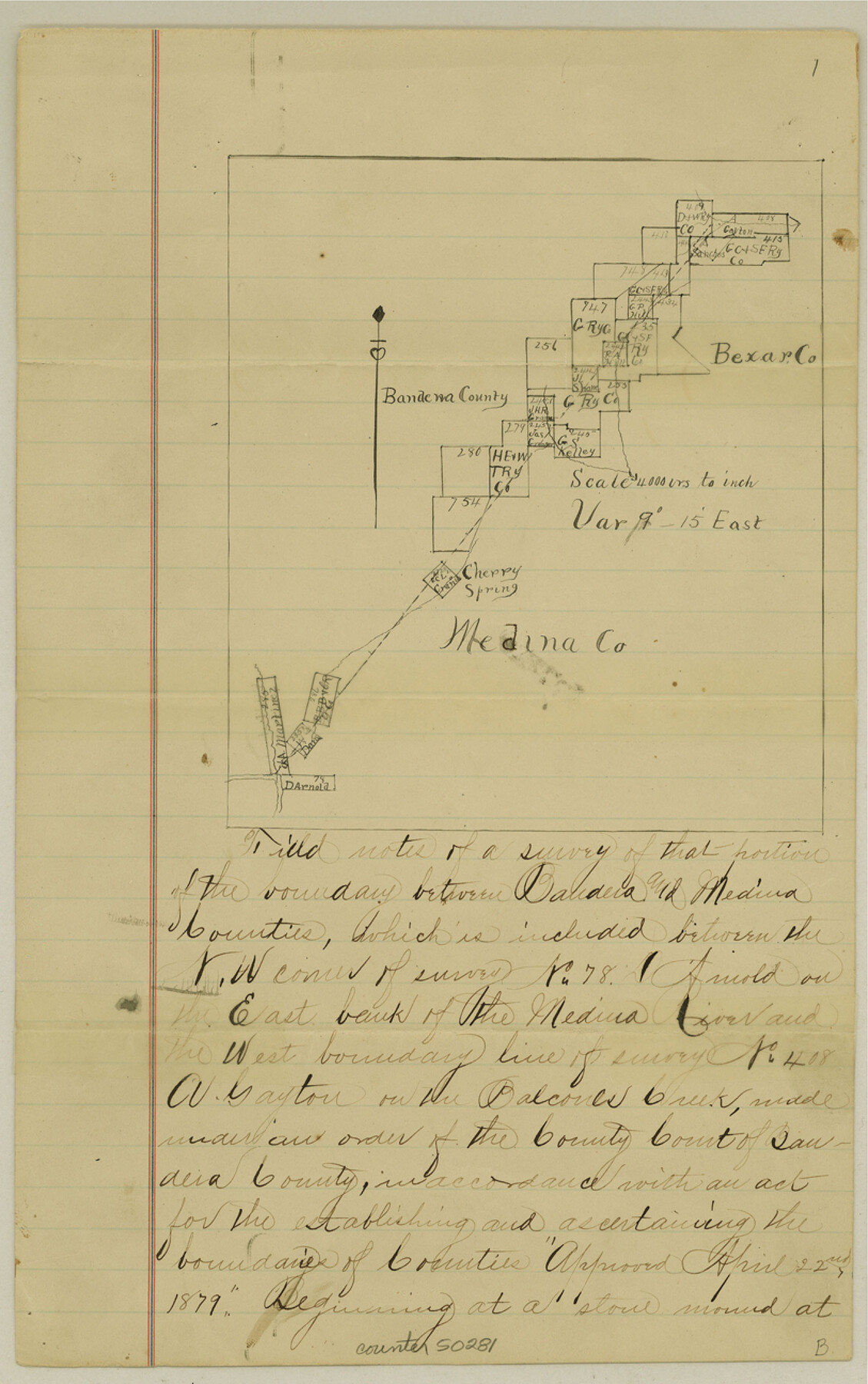
Bandera County Boundary File 4b
Fieldnotes of Boundary Line between Bandera and Medina Counties
-
Map/Doc
50281
-
Collection
General Map Collection
-
Counties
Bandera
-
Subjects
County Boundaries
-
Height x Width
13.0 x 8.1 inches
33.0 x 20.6 cm
Part of: General Map Collection
Terrell County Working Sketch 64

Print $20.00
- Digital $50.00
Terrell County Working Sketch 64
1971
Size 29.3 x 27.7 inches
Map/Doc 69585
Brazoria County Sketch File 12

Print $8.00
- Digital $50.00
Brazoria County Sketch File 12
1886
Size 12.8 x 8.2 inches
Map/Doc 14967
Current Miscellaneous File 86

Print $6.00
- Digital $50.00
Current Miscellaneous File 86
Size 11.2 x 8.8 inches
Map/Doc 74240
Limestone County Boundary File 59

Print $34.00
- Digital $50.00
Limestone County Boundary File 59
Size 7.4 x 8.7 inches
Map/Doc 56299
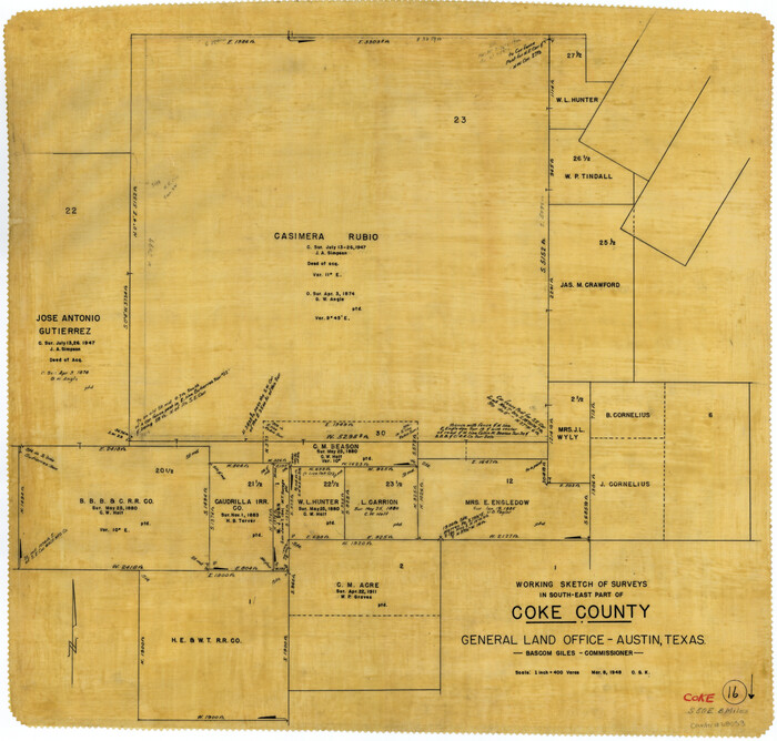
Coke County Working Sketch 16
Print $20.00
- Digital $50.00
Coke County Working Sketch 16
1948
Size 23.4 x 24.5 inches
Map/Doc 68053
Jeff Davis County Sketch File 12

Print $38.00
- Digital $50.00
Jeff Davis County Sketch File 12
1920
Size 14.6 x 9.1 inches
Map/Doc 27922
Map of El Paso County

Print $20.00
- Digital $50.00
Map of El Paso County
1888
Size 47.1 x 39.5 inches
Map/Doc 4942
Knox County Sketch File 19

Print $42.00
- Digital $50.00
Knox County Sketch File 19
Size 38.4 x 11.0 inches
Map/Doc 11961
Nolan County Sketch File 19

Print $20.00
- Digital $50.00
Nolan County Sketch File 19
1937
Size 17.3 x 19.6 inches
Map/Doc 42167
Tarrant County Working Sketch 26

Print $20.00
- Digital $50.00
Tarrant County Working Sketch 26
2004
Size 27.1 x 43.9 inches
Map/Doc 83586
Trinity County Sketch File 44

Print $8.00
- Digital $50.00
Trinity County Sketch File 44
1993
Size 11.3 x 9.0 inches
Map/Doc 38599
Abandoned and Canceled Surveys - Volume 3 of 3, Counties L-Z

Abandoned and Canceled Surveys - Volume 3 of 3, Counties L-Z
Map/Doc 83250
You may also like
Map of Coleman County

Print $20.00
- Digital $50.00
Map of Coleman County
1895
Size 26.1 x 18.9 inches
Map/Doc 3415
Gaines County Sketch File 23

Print $20.00
- Digital $50.00
Gaines County Sketch File 23
1964
Size 20.0 x 22.8 inches
Map/Doc 11529
Galveston County NRC Article 33.136 Sketch 84

Print $62.00
- Digital $50.00
Galveston County NRC Article 33.136 Sketch 84
2017
Size 17.2 x 22.0 inches
Map/Doc 94854
Gaines County Rolled Sketch 15

Print $40.00
- Digital $50.00
Gaines County Rolled Sketch 15
Size 73.5 x 23.4 inches
Map/Doc 9035
Aransas County Rolled Sketch 11

Print $20.00
- Digital $50.00
Aransas County Rolled Sketch 11
Size 42.0 x 36.4 inches
Map/Doc 8410
Dallam County

Print $20.00
- Digital $50.00
Dallam County
1888
Size 29.4 x 23.9 inches
Map/Doc 90641
Controlled Mosaic by Jack Amman Photogrammetric Engineers, Inc - Sheet 8

Print $20.00
- Digital $50.00
Controlled Mosaic by Jack Amman Photogrammetric Engineers, Inc - Sheet 8
1954
Size 20.0 x 24.0 inches
Map/Doc 83452
Liberty County Sketch File 20

Print $6.00
- Digital $50.00
Liberty County Sketch File 20
Size 7.8 x 9.9 inches
Map/Doc 29925
Rusk County Sketch File 17a

Print $4.00
Rusk County Sketch File 17a
Size 8.4 x 7.8 inches
Map/Doc 35522
Sheet 5 copied from Peck Book 6 [Strip Map showing T. & P. connecting lines]
![93171, Sheet 5 copied from Peck Book 6 [Strip Map showing T. & P. connecting lines], Twichell Survey Records](https://historictexasmaps.com/wmedia_w700/maps/93171-1.tif.jpg)
Print $40.00
- Digital $50.00
Sheet 5 copied from Peck Book 6 [Strip Map showing T. & P. connecting lines]
1909
Size 7.0 x 70.7 inches
Map/Doc 93171
Anderson County Rolled Sketch 12

Print $20.00
- Digital $50.00
Anderson County Rolled Sketch 12
1954
Size 24.6 x 21.3 inches
Map/Doc 77157
English Field Notes of the Spanish Archives - Books R & MC

English Field Notes of the Spanish Archives - Books R & MC
1835
Map/Doc 96552