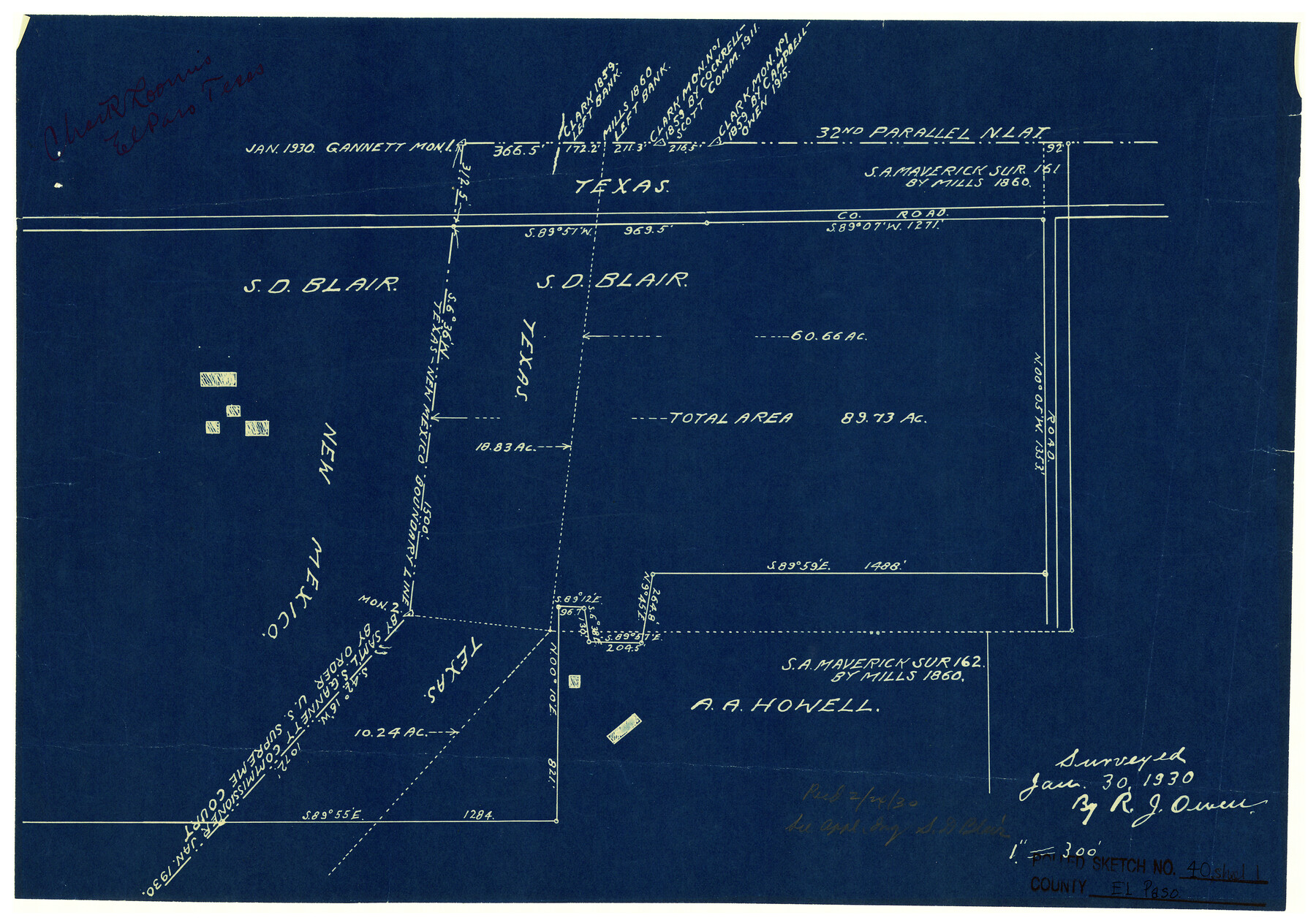
El Paso County Rolled Sketch 40
[Map of area on border of Texas and New Mexico just south of the 32nd parallel at the NW corner of the State]
-
Map/Doc
5826
-
Collection
General Map Collection
-
Object Dates
1/30/1930 (Creation Date)
2/24/1930 (File Date)
-
People and Organizations
R.J. Owen (Surveyor/Engineer)
-
Counties
El Paso
-
Subjects
Surveying Rolled Sketch
-
Height x Width
11.6 x 16.8 inches
29.5 x 42.7 cm
-
Medium
blueprint/diazo
-
Scale
1" = 300 feet
Part of: General Map Collection
Roberts County

Print $20.00
- Digital $50.00
Roberts County
1900
Size 43.4 x 42.0 inches
Map/Doc 63002
Terrell County Working Sketch 84c

Print $20.00
- Digital $50.00
Terrell County Working Sketch 84c
1992
Size 18.2 x 31.3 inches
Map/Doc 69607
Bee County Working Sketch 27

Print $20.00
- Digital $50.00
Bee County Working Sketch 27
1988
Size 27.0 x 23.4 inches
Map/Doc 67277
United States - Gulf Coast - Padre I. and Laguna Madre Lat. 27° 12' to Lat. 26° 33' Texas

Print $20.00
- Digital $50.00
United States - Gulf Coast - Padre I. and Laguna Madre Lat. 27° 12' to Lat. 26° 33' Texas
1913
Size 27.1 x 18.3 inches
Map/Doc 72818
Map of Johnson County & Hood County

Print $20.00
- Digital $50.00
Map of Johnson County & Hood County
1863
Size 19.3 x 28.3 inches
Map/Doc 3735
Panola County Rolled Sketch 6

Print $40.00
- Digital $50.00
Panola County Rolled Sketch 6
1956
Size 26.0 x 55.7 inches
Map/Doc 9679
Reeves County Sketch File 1

Print $10.00
- Digital $50.00
Reeves County Sketch File 1
Size 9.0 x 15.8 inches
Map/Doc 35176
Right of Way and Track Map, The Missouri, Kansas and Texas Ry. of Texas operated by the Missouri, Kansas and Texas Ry. of Texas, Henrietta Division

Print $40.00
- Digital $50.00
Right of Way and Track Map, The Missouri, Kansas and Texas Ry. of Texas operated by the Missouri, Kansas and Texas Ry. of Texas, Henrietta Division
1918
Size 25.5 x 56.6 inches
Map/Doc 64070
San Patricio County NRC Article 33.136 Sketch 5

Print $20.00
- Digital $50.00
San Patricio County NRC Article 33.136 Sketch 5
2006
Size 36.0 x 24.0 inches
Map/Doc 94697
Flight Mission No. CRE-2R, Frame 81, Jackson County

Print $20.00
- Digital $50.00
Flight Mission No. CRE-2R, Frame 81, Jackson County
1956
Size 18.6 x 22.2 inches
Map/Doc 85353
Edwards County Sketch File ABC

Print $12.00
- Digital $50.00
Edwards County Sketch File ABC
1913
Size 14.5 x 9.1 inches
Map/Doc 21662
Flight Mission No. CON-4R, Frame 88, Stonewall County

Print $20.00
- Digital $50.00
Flight Mission No. CON-4R, Frame 88, Stonewall County
1957
Size 18.2 x 22.0 inches
Map/Doc 86992
You may also like
Cottle County Working Sketch Graphic Index

Print $20.00
- Digital $50.00
Cottle County Working Sketch Graphic Index
1971
Size 41.8 x 33.8 inches
Map/Doc 76506
[Blocks Z3, S, H1 and 1 and vicinity]
![93120, [Blocks Z3, S, H1 and 1 and vicinity], Twichell Survey Records](https://historictexasmaps.com/wmedia_w700/maps/93120-1.tif.jpg)
Print $40.00
- Digital $50.00
[Blocks Z3, S, H1 and 1 and vicinity]
Size 54.0 x 32.2 inches
Map/Doc 93120
San Patricio County Working Sketch 10

Print $20.00
- Digital $50.00
San Patricio County Working Sketch 10
1939
Size 28.1 x 32.6 inches
Map/Doc 63772
Reeves County Rolled Sketch 14

Print $20.00
- Digital $50.00
Reeves County Rolled Sketch 14
Size 17.7 x 21.8 inches
Map/Doc 7482
General Highway Map, Wood County, Texas

Print $20.00
General Highway Map, Wood County, Texas
1961
Size 18.1 x 24.8 inches
Map/Doc 79718
Real County Working Sketch 51

Print $20.00
- Digital $50.00
Real County Working Sketch 51
1957
Size 28.1 x 24.1 inches
Map/Doc 71943
Map of Glasscock County

Print $20.00
- Digital $50.00
Map of Glasscock County
Size 19.1 x 23.1 inches
Map/Doc 90781
Borden County Boundary File 4

Print $2.00
- Digital $50.00
Borden County Boundary File 4
Size 13.3 x 8.3 inches
Map/Doc 50636
Flight Mission No. BQR-22K, Frame 46, Brazoria County

Print $20.00
- Digital $50.00
Flight Mission No. BQR-22K, Frame 46, Brazoria County
1953
Size 18.6 x 22.4 inches
Map/Doc 84130
[Sketch for Mineral Application 36425 - Jefferson County, Ley C. Moore]
![65616, [Sketch for Mineral Application 36425 - Jefferson County, Ley C. Moore], General Map Collection](https://historictexasmaps.com/wmedia_w700/maps/65616.tif.jpg)
Print $40.00
- Digital $50.00
[Sketch for Mineral Application 36425 - Jefferson County, Ley C. Moore]
1942
Size 49.2 x 35.0 inches
Map/Doc 65616

South Part Presidio County

Print $20.00
- Digital $50.00
South Part Presidio County
1975
Size 31.6 x 37.2 inches
Map/Doc 77400