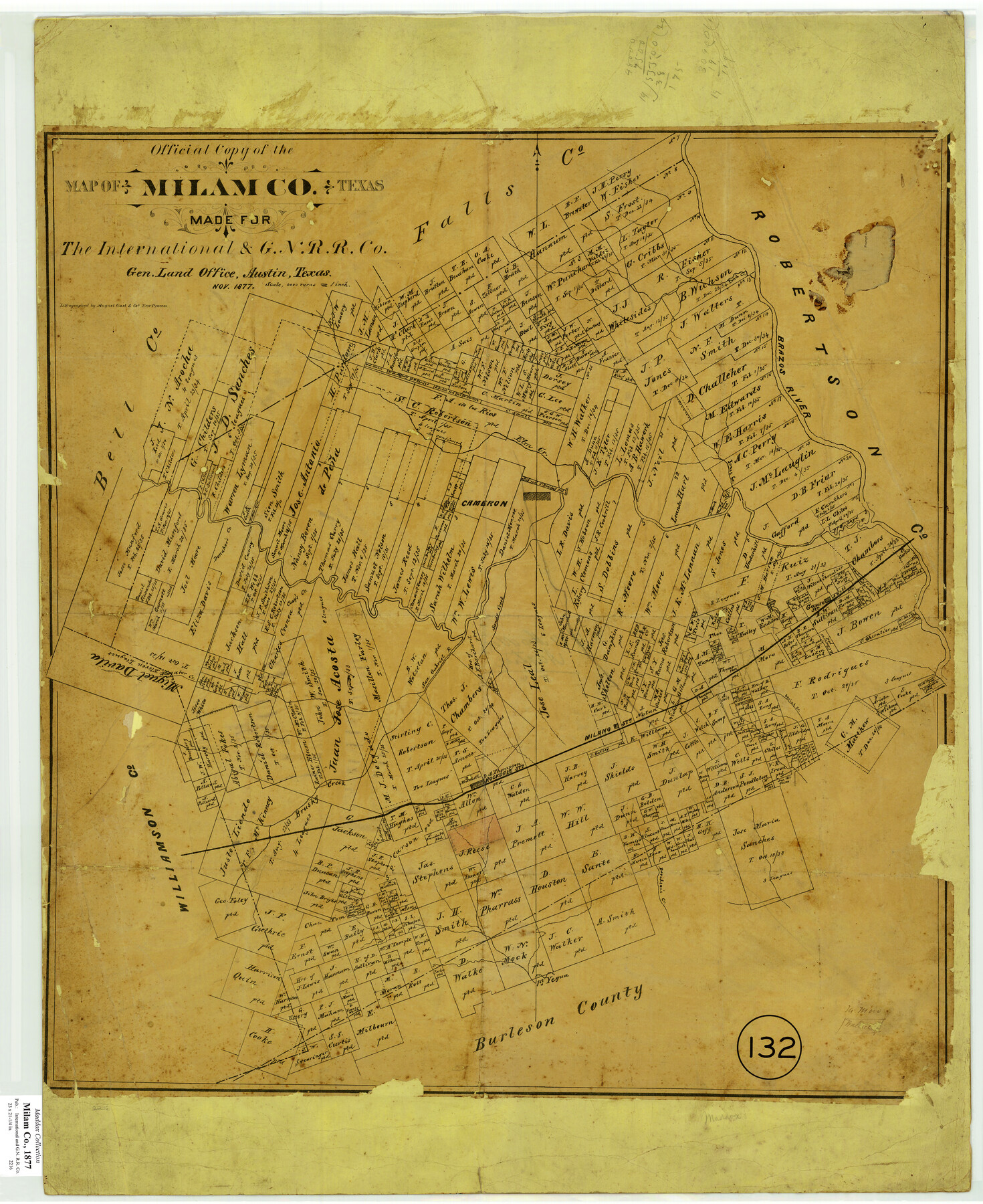
Official Copy of the Map of Milam County made for the International and G. N. R. R. Co.
-
Map/Doc
581
-
Collection
Maddox Collection
-
Object Dates
1877 (Creation Date)
-
People and Organizations
General Land Office (Publisher)
August Gast & Co. (Lithographer)
-
Counties
Milam
-
Subjects
County
-
Height x Width
23.9 x 22.5 inches
60.7 x 57.2 cm
-
Medium
paper, etching/engraving/lithograph
-
Scale
1:4000
-
Comments
Conservation funded in 2004 with donation from Mr. and Mrs. Casey McManemin in memory of John Harlan
-
Features
Sandy Creek
1st Yegua [Creek]
Davidson's Creek
Brushy Creek
Spring Creek
Milano St[atio]n
Rockdale St[atio]n
Alligator Creek
San Gabriel River
Pond Creek
Gause St[atio]n
Clay's Creek
Donahoe's Creek
Cameron
Elm Creek
Jones Creek
Brazos River
Part of: Maddox Collection
[Littlefield & White Survey, Kimble County, Texas]
![570, [Littlefield & White Survey, Kimble County, Texas], Maddox Collection](https://historictexasmaps.com/wmedia_w700/maps/0570.tif.jpg)
Print $20.00
- Digital $50.00
[Littlefield & White Survey, Kimble County, Texas]
Size 18.6 x 14.2 inches
Map/Doc 570
Survey in South Austin for Mr. R.N. Graham

Print $20.00
- Digital $50.00
Survey in South Austin for Mr. R.N. Graham
Map/Doc 93795
Foard County, Texas

Print $20.00
- Digital $50.00
Foard County, Texas
1891
Size 20.6 x 24.5 inches
Map/Doc 4338
Childress County, Texas

Print $20.00
- Digital $50.00
Childress County, Texas
1892
Size 29.3 x 22.0 inches
Map/Doc 697
[El Javali Grant,] Sketch of 2560 acres of land in Starr County
![474, [El Javali Grant,] Sketch of 2560 acres of land in Starr County, Maddox Collection](https://historictexasmaps.com/wmedia_w700/maps/0474.tif.jpg)
Print $20.00
- Digital $50.00
[El Javali Grant,] Sketch of 2560 acres of land in Starr County
Size 13.4 x 14.0 inches
Map/Doc 474

[Surveying Sketch of Heirs of Wm Neil, J.J. Hall, Robert Sikes, et al in Hutchinson County, Texas]
![75778, [Surveying Sketch of Heirs of Wm Neil, J.J. Hall, Robert Sikes, et al in Hutchinson County, Texas], Maddox Collection](https://historictexasmaps.com/wmedia_w700/maps/75778-1.tif.jpg)
Print $20.00
- Digital $50.00
[Surveying Sketch of Heirs of Wm Neil, J.J. Hall, Robert Sikes, et al in Hutchinson County, Texas]
Size 15.6 x 20.5 inches
Map/Doc 75778
Working Sketch in Dickens & King Cos.

Print $20.00
- Digital $50.00
Working Sketch in Dickens & King Cos.
Size 24.4 x 20.4 inches
Map/Doc 10770
Map of survey 189, T. C. R.R. Co. in Travis County, Texas

Print $20.00
- Digital $50.00
Map of survey 189, T. C. R.R. Co. in Travis County, Texas
1915
Size 18.6 x 15.2 inches
Map/Doc 78479
Survey 1, Block 1, D.B. Gardner in Dickens County

Print $20.00
- Digital $50.00
Survey 1, Block 1, D.B. Gardner in Dickens County
1914
Size 14.9 x 30.4 inches
Map/Doc 10767
[Surveying Sketch of Jesse McGee, Jas McKim, W. S. Kennard, et al in Sabine and Newton Counties, Texas]
![5066, [Surveying Sketch of Jesse McGee, Jas McKim, W. S. Kennard, et al in Sabine and Newton Counties, Texas], Maddox Collection](https://historictexasmaps.com/wmedia_w700/maps/5066.tif.jpg)
Print $20.00
- Digital $50.00
[Surveying Sketch of Jesse McGee, Jas McKim, W. S. Kennard, et al in Sabine and Newton Counties, Texas]
1916
Size 32.0 x 37.5 inches
Map/Doc 5066
Hopkins County

Print $20.00
- Digital $50.00
Hopkins County
1888
Size 36.4 x 36.6 inches
Map/Doc 448
You may also like

Gaines County Sketch File 6

Print $20.00
- Digital $50.00
Gaines County Sketch File 6
1924
Size 20.9 x 21.3 inches
Map/Doc 11523
Aransas County Rolled Sketch 25

Print $20.00
- Digital $50.00
Aransas County Rolled Sketch 25
1983
Size 18.4 x 24.5 inches
Map/Doc 5061
Duval County Sketch File 53

Print $4.00
- Digital $50.00
Duval County Sketch File 53
1937
Size 11.6 x 7.3 inches
Map/Doc 21416
Coke County Working Sketch 11
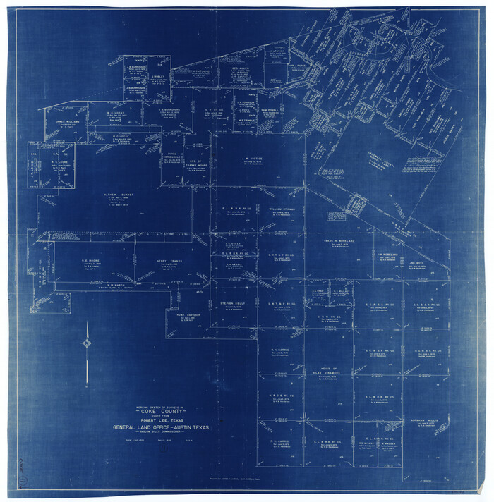
Print $20.00
- Digital $50.00
Coke County Working Sketch 11
1945
Size 40.9 x 40.2 inches
Map/Doc 68048
Wharton County Rolled Sketch 6

Print $20.00
- Digital $50.00
Wharton County Rolled Sketch 6
1901
Size 23.7 x 30.0 inches
Map/Doc 8230

Morris County Rolled Sketch 2A

Print $20.00
- Digital $50.00
Morris County Rolled Sketch 2A
Size 22.5 x 17.6 inches
Map/Doc 10230
Map of Bailey County, Texas

Print $20.00
- Digital $50.00
Map of Bailey County, Texas
1912
Size 15.8 x 19.8 inches
Map/Doc 90248
[North part of G. C. & S. F. Block OP, Runnels County School Land and Blks. AB, CD and GH]
![90310, [North part of G. C. & S. F. Block OP, Runnels County School Land and Blks. AB, CD and GH], Twichell Survey Records](https://historictexasmaps.com/wmedia_w700/maps/90310-1.tif.jpg)
Print $20.00
- Digital $50.00
[North part of G. C. & S. F. Block OP, Runnels County School Land and Blks. AB, CD and GH]
Size 17.5 x 22.4 inches
Map/Doc 90310
[Movements & Objectives of the 143rd & 144th Infantry & 133rd Machine Gun Battalion on October 8-9, 1918, Appendix E, No. 4]
![94133, [Movements & Objectives of the 143rd & 144th Infantry & 133rd Machine Gun Battalion on October 8-9, 1918, Appendix E, No. 4], Non-GLO Digital Images](https://historictexasmaps.com/wmedia_w700/maps/94133-1.tif.jpg)
Print $20.00
[Movements & Objectives of the 143rd & 144th Infantry & 133rd Machine Gun Battalion on October 8-9, 1918, Appendix E, No. 4]
1918
Size 21.5 x 20.2 inches
Map/Doc 94133
Montgomery County Rolled Sketch 40A

Print $40.00
- Digital $50.00
Montgomery County Rolled Sketch 40A
1970
Size 40.4 x 57.5 inches
Map/Doc 9547