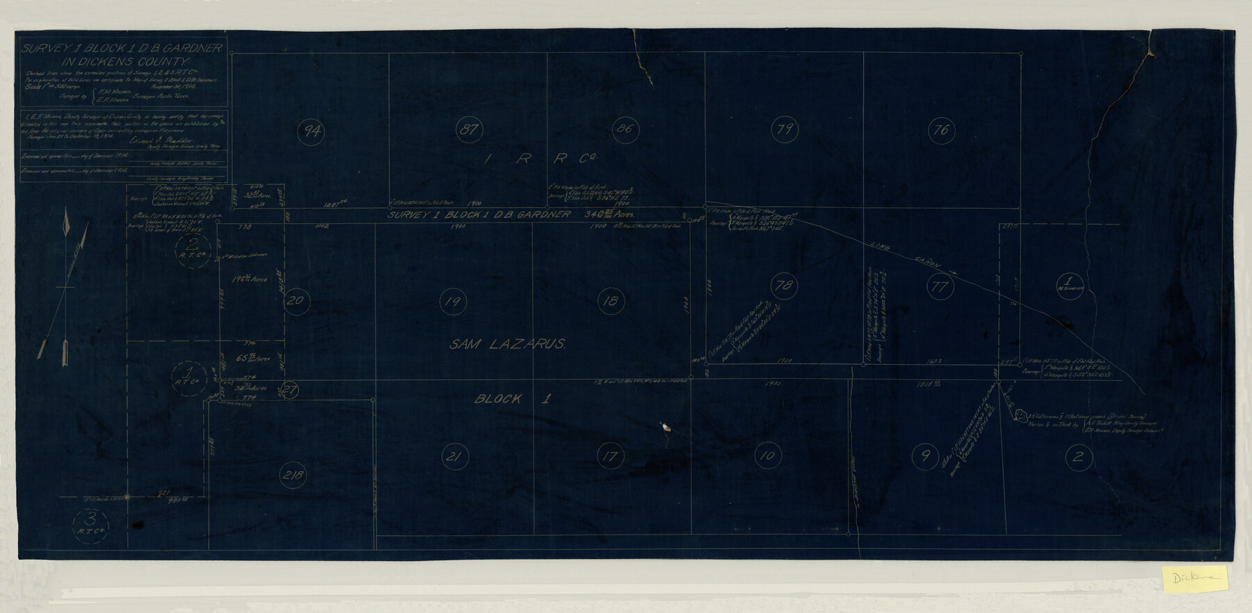
Survey 1, Block 1, D.B. Gardner in Dickens County
-
Map/Doc
10767
-
Collection
Maddox Collection
-
Object Dates
1914/11/30 (Creation Date)
-
People and Organizations
E.F. Maddox (Surveyor/Engineer)
F.M. Maddox (Surveyor/Engineer)
-
Counties
Dickens King
-
Height x Width
14.9 x 30.4 inches
37.8 x 77.2 cm
-
Medium
blueprint/diazo
-
Scale
1" = 500 varas
-
Features
Davidson Cañon
Long Cañon
Part of: Maddox Collection
Fayette County, Texas

Print $20.00
- Digital $50.00
Fayette County, Texas
1879
Size 19.9 x 23.0 inches
Map/Doc 419
Map of Kinney County, Texas

Print $20.00
- Digital $50.00
Map of Kinney County, Texas
1879
Size 21.2 x 33.1 inches
Map/Doc 548
Resurvey of H.L. Upshur's April 23, 1853 meanders of the Colorado River from the NE corner of Isaac Decker league to the Congress Avenue Bridge

Print $20.00
- Digital $50.00
Resurvey of H.L. Upshur's April 23, 1853 meanders of the Colorado River from the NE corner of Isaac Decker league to the Congress Avenue Bridge
1915
Size 24.0 x 16.3 inches
Map/Doc 75773
Sketch showing subdivision of surveys in Webb Co., Texas

Print $20.00
- Digital $50.00
Sketch showing subdivision of surveys in Webb Co., Texas
1933
Size 18.2 x 20.1 inches
Map/Doc 459
Spence Addition Owned by L.N. Goldbeck and Herman Pressler - A Subdivision of Outlot 43, Division "O"

Print $20.00
- Digital $50.00
Spence Addition Owned by L.N. Goldbeck and Herman Pressler - A Subdivision of Outlot 43, Division "O"
1913
Size 15.5 x 12.8 inches
Map/Doc 83424
Map of Rockport Texas, Aransas County

Print $20.00
- Digital $50.00
Map of Rockport Texas, Aransas County
1888
Size 29.0 x 20.5 inches
Map/Doc 380
Surveys in Greer Co.

Print $20.00
- Digital $50.00
Surveys in Greer Co.
Size 16.6 x 14.4 inches
Map/Doc 557
Borden County, Texas

Print $20.00
- Digital $50.00
Borden County, Texas
1887
Size 19.9 x 18.3 inches
Map/Doc 596
Map of Bastrop County, Texas

Print $20.00
- Digital $50.00
Map of Bastrop County, Texas
1879
Size 25.2 x 23.3 inches
Map/Doc 693
[Surveying Sketch of Houston and Texas Central R. R. Co., Gunter & Munson, Houston & Great Northern R. R. Co., International & Great Northern R. R. Company, et al]
![75763, [Surveying Sketch of Houston and Texas Central R. R. Co., Gunter & Munson, Houston & Great Northern R. R. Co., International & Great Northern R. R. Company, et al], Maddox Collection](https://historictexasmaps.com/wmedia_w700/maps/75763.tif.jpg)
Print $20.00
- Digital $50.00
[Surveying Sketch of Houston and Texas Central R. R. Co., Gunter & Munson, Houston & Great Northern R. R. Co., International & Great Northern R. R. Company, et al]
Size 23.1 x 28.3 inches
Map/Doc 75763
Oldham County, Texas

Print $20.00
- Digital $50.00
Oldham County, Texas
1880
Size 21.2 x 26.8 inches
Map/Doc 745
[Sketch Showing Blocks in Hansford County, Texas]
![75818, [Sketch Showing Blocks in Hansford County, Texas], Maddox Collection](https://historictexasmaps.com/wmedia_w700/maps/75818.tif.jpg)
Print $20.00
- Digital $50.00
[Sketch Showing Blocks in Hansford County, Texas]
1890
Size 34.3 x 24.6 inches
Map/Doc 75818
You may also like
Rusk County Working Sketch 34

Print $20.00
- Digital $50.00
Rusk County Working Sketch 34
1994
Size 43.5 x 33.1 inches
Map/Doc 63671
Jackson County Sketch File 14

Print $40.00
- Digital $50.00
Jackson County Sketch File 14
Size 22.2 x 9.8 inches
Map/Doc 27660
Texas Gulf Coast, from the Sabine River to the Rio Grande as Subdivided for Mineral Development; Jefferson, Chambers and Galveston Counties

Print $20.00
- Digital $50.00
Texas Gulf Coast, from the Sabine River to the Rio Grande as Subdivided for Mineral Development; Jefferson, Chambers and Galveston Counties
1976
Size 29.0 x 42.5 inches
Map/Doc 1937
Current Miscellaneous File 37

Print $4.00
- Digital $50.00
Current Miscellaneous File 37
Size 13.2 x 8.7 inches
Map/Doc 73956
General Highway Map, Hall County, Texas

Print $20.00
General Highway Map, Hall County, Texas
1940
Size 18.3 x 25.0 inches
Map/Doc 79110
Terrell County Sketch File 17

Print $13.00
- Digital $50.00
Terrell County Sketch File 17
Size 10.1 x 8.1 inches
Map/Doc 37935
Cottle County Working Sketch 23

Print $20.00
- Digital $50.00
Cottle County Working Sketch 23
1992
Size 26.6 x 24.2 inches
Map/Doc 68333
Part of Laguna Madre in Kenedy and Willacy Counties, showing Subdivision for Mineral Development

Print $40.00
- Digital $50.00
Part of Laguna Madre in Kenedy and Willacy Counties, showing Subdivision for Mineral Development
1946
Size 49.1 x 30.0 inches
Map/Doc 1924
La Salle County Rolled Sketch 21

Print $77.00
- Digital $50.00
La Salle County Rolled Sketch 21
1955
Size 10.0 x 15.1 inches
Map/Doc 46461
Brewster County Sketch File 52

Print $16.00
- Digital $50.00
Brewster County Sketch File 52
1996
Size 14.1 x 8.8 inches
Map/Doc 16357
Burleson County Working Sketch 8

Print $20.00
- Digital $50.00
Burleson County Working Sketch 8
1980
Size 29.3 x 23.2 inches
Map/Doc 67727
Culberson County Working Sketch 80

Print $40.00
- Digital $50.00
Culberson County Working Sketch 80
1978
Size 56.4 x 43.4 inches
Map/Doc 68534