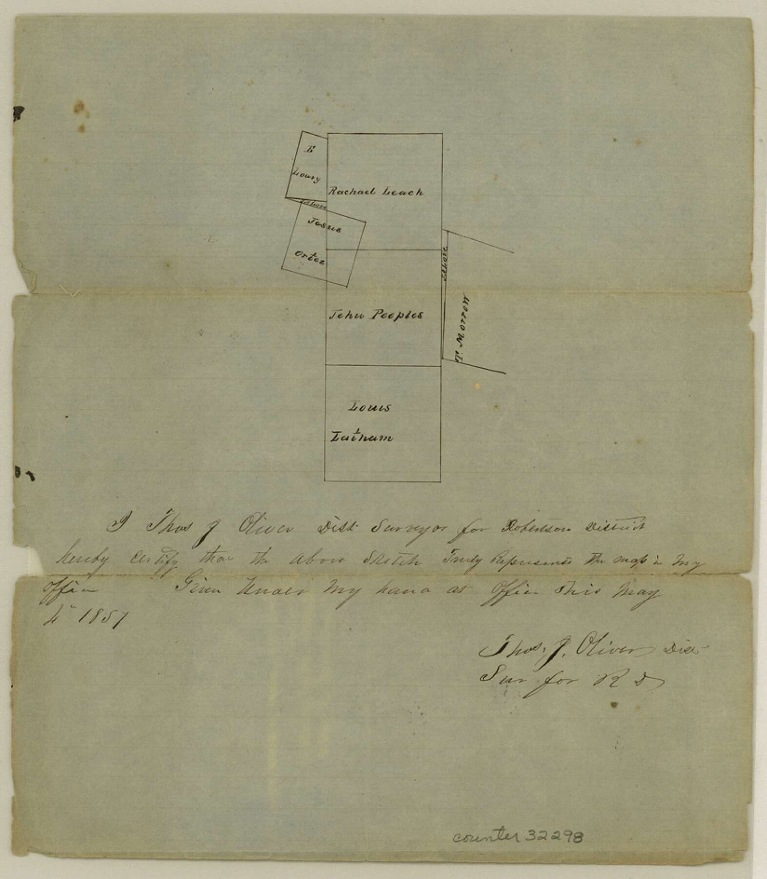
Navarro County Sketch File 2
[Sketch of surveys near Corsicana]
- 
                          Map/Doc
32298
 - 
                            Collection
General Map Collection
 - 
                            Object Dates
1857/5/4 (Creation Date)
1858/2/3 (File Date)
 - 
                            People and Organizations
T.J. Oliver (Surveyor/Engineer)
 - 
                            Counties
Navarro
 - 
                            Subjects
Surveying Sketch File
 - 
                            Height x Width
9.4 x 8.2 inches
23.9 x 20.8 cm
 - 
                            Medium
paper, manuscript
 
Part of: General Map Collection
            La Salle County


                                            Print $20.00                    
                                             -                         Digital $50.00                                    
                La Salle County
1923
Size 39.7 x 34.5 inches
                                Map/Doc 77348
            
            San Jacinto County Rolled Sketch 9


                                            Print $20.00                    
                                             -                         Digital $50.00                                    
                San Jacinto County Rolled Sketch 9
1944
Size 39.9 x 36.8 inches
                                Map/Doc 9881
            
            Trinity River, Levee Improvement Districts, Widths of Floodways


                                            Print $20.00                    
                                             -                         Digital $50.00                                    
                Trinity River, Levee Improvement Districts, Widths of Floodways
1923
Size 37.6 x 28.2 inches
                                Map/Doc 65253
            
            Anderson County Rolled Sketch 6


                                            Print $40.00                    
                                             -                         Digital $50.00                                    
                Anderson County Rolled Sketch 6
Size 93.3 x 43.5 inches
                                Map/Doc 81901
            
            Potter County Working Sketch 5


                                            Print $20.00                    
                                             -                         Digital $50.00                                    
                Potter County Working Sketch 5
1920
Size 41.3 x 37.1 inches
                                Map/Doc 71665
            
            Flight Mission No. CRC-3R, Frame 14, Chambers County


                                            Print $20.00                    
                                             -                         Digital $50.00                                    
                Flight Mission No. CRC-3R, Frame 14, Chambers County
1956
Size 18.6 x 22.3 inches
                                Map/Doc 84788
            
            Harbor Pass and Bar at Brazos Santiago, Texas


                                            Print $20.00                    
                                             -                         Digital $50.00                                    
                Harbor Pass and Bar at Brazos Santiago, Texas
1871
Size 26.8 x 18.3 inches
                                Map/Doc 72984
            
            Uvalde County Working Sketch 8


                                            Print $20.00                    
                                             -                         Digital $50.00                                    
                Uvalde County Working Sketch 8
1942
Size 37.4 x 23.6 inches
                                Map/Doc 72078
            
            Erforschung von Nordwest-Texas


                                            Print $20.00                    
                                             -                         Digital $50.00                                    
                Erforschung von Nordwest-Texas
Size 11.4 x 9.4 inches
                                Map/Doc 95144
            
            Map of South Louisiana and Louisiana Continental Shelf showing Natural Gas Pipe Lines


                                            Print $40.00                    
                                             -                         Digital $50.00                                    
                Map of South Louisiana and Louisiana Continental Shelf showing Natural Gas Pipe Lines
Size 40.0 x 56.0 inches
                                Map/Doc 75906
            
            Travis County Boundary File 5


                                            Print $62.00                    
                                             -                         Digital $50.00                                    
                Travis County Boundary File 5
Size 9.1 x 4.4 inches
                                Map/Doc 59430
            You may also like
            Gonzales County Sketch File 2


                                            Print $10.00                    
                                             -                         Digital $50.00                                    
                Gonzales County Sketch File 2
Size 8.9 x 7.8 inches
                                Map/Doc 24357
            
            Howard County


                                            Print $20.00                    
                                             -                         Digital $50.00                                    
                Howard County
1922
Size 42.3 x 36.2 inches
                                Map/Doc 95535
            
            Calhoun County Sketch File 1


                                            Print $7.00                    
                                             -                         Digital $50.00                                    
                Calhoun County Sketch File 1
1855
Size 17.1 x 11.0 inches
                                Map/Doc 11031
            
            Flight Mission No. CGI-3N, Frame 184, Cameron County


                                            Print $20.00                    
                                             -                         Digital $50.00                                    
                Flight Mission No. CGI-3N, Frame 184, Cameron County
1954
Size 18.5 x 22.3 inches
                                Map/Doc 84648
            
            Reeves County Rolled Sketch 40


                                            Print $20.00                    
                                             -                         Digital $50.00                                    
                Reeves County Rolled Sketch 40
2019
Size 18.1 x 24.2 inches
                                Map/Doc 95826
            
            [Blocks and surveys to the North and West of Jasper County School Land]


                                            Print $20.00                    
                                             -                         Digital $50.00                                    
                [Blocks and surveys to the North and West of Jasper County School Land]
Size 14.9 x 17.8 inches
                                Map/Doc 91570
            
            Howard County Rolled Sketch 7


                                            Print $20.00                    
                                             -                         Digital $50.00                                    
                Howard County Rolled Sketch 7
Size 12.0 x 16.7 inches
                                Map/Doc 6236
            
            Henderson County Working Sketch 29


                                            Print $20.00                    
                                             -                         Digital $50.00                                    
                Henderson County Working Sketch 29
1961
Size 39.3 x 41.9 inches
                                Map/Doc 66162
            
            Montgomery County Sketch File 21


                                            Print $8.00                    
                                             -                         Digital $50.00                                    
                Montgomery County Sketch File 21
1934
Size 9.0 x 13.2 inches
                                Map/Doc 31856