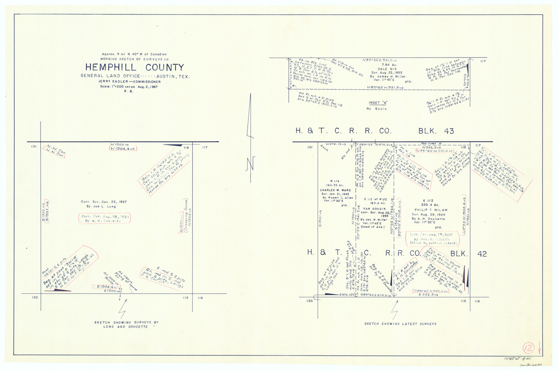
Hemphill County Working Sketch 12
-
Map/Doc
66107
-
Collection
General Map Collection
-
Object Dates
8/2/1967 (Creation Date)
-
People and Organizations
Roy Buckholts (Draftsman)
-
Counties
Hemphill
-
Subjects
Surveying Working Sketch
-
Height x Width
23.3 x 34.9 inches
59.2 x 88.7 cm
-
Scale
1" = 200 varas
Part of: General Map Collection
Live Oak County Working Sketch 18

Print $6.00
- Digital $50.00
Live Oak County Working Sketch 18
1961
Size 30.2 x 29.6 inches
Map/Doc 70603
Walker County

Print $20.00
- Digital $50.00
Walker County
1944
Size 44.8 x 38.5 inches
Map/Doc 63106
Val Verde County Sketch File Z12

Print $4.00
- Digital $50.00
Val Verde County Sketch File Z12
1898
Size 11.4 x 8.8 inches
Map/Doc 39140
Val Verde County Working Sketch 12

Print $20.00
- Digital $50.00
Val Verde County Working Sketch 12
1920
Size 29.0 x 24.3 inches
Map/Doc 72147
Fannin County Boundary File 3

Print $36.00
- Digital $50.00
Fannin County Boundary File 3
Size 13.2 x 8.8 inches
Map/Doc 53295

Map of Yoakum County

Print $40.00
- Digital $50.00
Map of Yoakum County
1900
Size 51.2 x 38.7 inches
Map/Doc 4169
Castro County Sketch File 4f

Print $4.00
- Digital $50.00
Castro County Sketch File 4f
Size 13.8 x 8.9 inches
Map/Doc 17475
Map of Chambers Co.

Print $20.00
- Digital $50.00
Map of Chambers Co.
1901
Size 24.9 x 25.1 inches
Map/Doc 4907
[Cotton Belt, St. Louis Southwestern Railway of Texas, Alignment through Smith County]
![64384, [Cotton Belt, St. Louis Southwestern Railway of Texas, Alignment through Smith County], General Map Collection](https://historictexasmaps.com/wmedia_w700/maps/64384.tif.jpg)
Print $20.00
- Digital $50.00
[Cotton Belt, St. Louis Southwestern Railway of Texas, Alignment through Smith County]
1903
Size 21.4 x 29.9 inches
Map/Doc 64384
Right of Way and Track Map, International & Gt. Northern Ry. Operated by the International & Gt. Northern Ry. Co., Gulf Division

Print $40.00
- Digital $50.00
Right of Way and Track Map, International & Gt. Northern Ry. Operated by the International & Gt. Northern Ry. Co., Gulf Division
1917
Size 24.9 x 56.6 inches
Map/Doc 64250
La Salle County Working Sketch 26

Print $4.00
- Digital $50.00
La Salle County Working Sketch 26
1949
Size 28.2 x 16.3 inches
Map/Doc 70327
You may also like
Real County Rolled Sketch 18

Print $20.00
- Digital $50.00
Real County Rolled Sketch 18
Size 21.2 x 27.7 inches
Map/Doc 7465
United States - Gulf Coast - From Latitude 26° 33' to the Rio Grande Texas

Print $20.00
- Digital $50.00
United States - Gulf Coast - From Latitude 26° 33' to the Rio Grande Texas
1918
Size 18.3 x 24.1 inches
Map/Doc 72845
[Blocks 21, 22, 23, and 24]
![91110, [Blocks 21, 22, 23, and 24], Twichell Survey Records](https://historictexasmaps.com/wmedia_w700/maps/91110-1.tif.jpg)
Print $20.00
- Digital $50.00
[Blocks 21, 22, 23, and 24]
Size 14.0 x 12.8 inches
Map/Doc 91110
Hemphill County Working Sketch 3

Print $40.00
- Digital $50.00
Hemphill County Working Sketch 3
1940
Size 51.8 x 27.4 inches
Map/Doc 66098
Coryell County Sketch File 19

Print $20.00
- Digital $50.00
Coryell County Sketch File 19
Size 14.8 x 12.4 inches
Map/Doc 19380
Chocolate Bay, West Portion of West Bay and Vicinity, and Galveston Cos. Showing Subdivision for Mineral Development.

Print $40.00
- Digital $50.00
Chocolate Bay, West Portion of West Bay and Vicinity, and Galveston Cos. Showing Subdivision for Mineral Development.
1948
Size 43.0 x 55.9 inches
Map/Doc 3012
Dallas County Working Sketch 12

Print $20.00
- Digital $50.00
Dallas County Working Sketch 12
1983
Size 30.5 x 44.1 inches
Map/Doc 68578
McMullen County Sketch File 4

Print $4.00
- Digital $50.00
McMullen County Sketch File 4
Size 7.9 x 10.1 inches
Map/Doc 31341
Reagan County Sketch File 31

Print $20.00
- Digital $50.00
Reagan County Sketch File 31
1951
Size 24.9 x 20.5 inches
Map/Doc 12227
Crockett County Rolled Sketch 97

Print $20.00
- Digital $50.00
Crockett County Rolled Sketch 97
2013
Size 22.9 x 24.8 inches
Map/Doc 93664
[Right of Way Map, Belton Branch of the M.K.&T. RR.]
![64226, [Right of Way Map, Belton Branch of the M.K.&T. RR.], General Map Collection](https://historictexasmaps.com/wmedia_w700/maps/64226.tif.jpg)
Print $20.00
- Digital $50.00
[Right of Way Map, Belton Branch of the M.K.&T. RR.]
1896
Size 7.2 x 21.9 inches
Map/Doc 64226
San Patricio County Rolled Sketch 31

Print $20.00
- Digital $50.00
San Patricio County Rolled Sketch 31
1941
Size 43.1 x 42.6 inches
Map/Doc 9898